Eutaw, Mississippi | |
|---|---|
 Eutaw, Mississippi | |
| Coordinates: 33°39′31″N91°09′02″W / 33.65861°N 91.15056°W | |
| Country | United States |
| State | Mississippi |
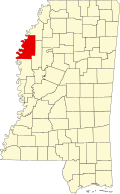
| County | Bolivar |
| Elevation | 131 ft (40 m) |
| Time zone | UTC-6 (Central (CST)) |
| • Summer (DST) | UTC-5 (CDT) |
| GNIS feature ID | 669829 [1] |
Eutaw is a ghost town in Bolivar County, Mississippi, United States. [1] The settlement had a port on the Mississippi River called "Eutaw Landing." [2]
The community was located on the Eutaw Plantation, and included a post office, store, church, and cemetery. [1] [3] A post office operated under the name Eutaw from 1890 to 1952. [4]
The former community is covered by farmfield and a portion of the Mississippi Levee; the only remnant is the Eutaw Cemetery. [5]