
Oxfordshire is a county in South East England. The ceremonial county borders Warwickshire to the north-west, Northamptonshire to the north-east, Buckinghamshire to the east, Berkshire to the south, Wiltshire to the south-west and Gloucestershire to the west.
Clawson, Hose and Harby is a civil parish in Leicestershire, England, forming part of the Melton district. It contains the villages of Harby, Hose and Long Clawson and the parish was created from those former parishes on the 1st of April 1936. The population of the civil parish at the 2011 census was 2,577.
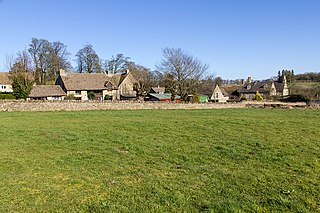
Appleton-with-Eaton is a civil parish in the Vale of White Horse district of Oxfordshire, England, south west of Oxford. It consists of Appleton and Eaton, on the south bank of the River Thames. Its area is 8.38km². According to the 2011 census the parish had a 915 residents, an increase of 18 over ten years.
Beckley and Stowood is a civil parish in the South Oxfordshire district of Oxfordshire, England. According to the United Kingdom Census 2011 it had a population of 608 across its area of 9.17km². It is centred 3 miles (4.8 km) north-east of Oxford and just over 1 mile (1.6 km) west of the M40 motorway. The parish settlements are Beckley and Stowood which is covered in the Beckley article, long being closely associated.
Blenheim is a civil parish in West Oxfordshire, England, about 7 miles (11 km) north of Oxford. It includes Blenheim Palace.

St Martin's Church in Bladon near Woodstock, Oxfordshire, England, is the Church of England parish church of Bladon-with-Woodstock. It is also the mother church of St Mary Magdalene at Woodstock, which was originally a chapel of ease. It is best known for the graves of the Spencer-Churchill family, including Sir Winston Churchill, in its churchyard.
Fencott and Murcott is a civil parish about 4 miles (6 km) south of Bicester in the Cherwell district of Oxfordshire, England.
Winterbrook is a small settlement in the English county of Oxfordshire, which adjoins the south end of Wallingford and sits on the west bank of the Thames. In 1974 it was transferred from Berkshire. Although having been part of the adjacent parish of Cholsey for centuries, its proximity to Wallingford resulted in its being absorbed into that town for administrative purposes in 2015. This change was effected despite the strenuous and long-term objections of the residents.
Sarsden Halt was an unstaffed railway station on the Banbury and Cheltenham Direct Railway.
Kiddington with Asterleigh is a civil parish in West Oxfordshire. It contains the small village of Kiddington, the hamlet of Over Kiddington and Asterleigh, which is the site of an abandoned Mediaeval village at 51°53′54″N01°25′22″W.

Brookhampton is a hamlet in the village and civil parish of Stadhampton, 5 miles (8.0 km) north of Wallingford, in South Oxfordshire, England.
Curbridge and Lew are civil parishes in West Oxfordshire, located to the south-west of Witney, Oxfordshire, that share a common parish council.
Baldons is a joint parish council area covering the civil parishes of Toot Baldon and Marsh Baldon, in the South Oxfordshire district about 5 miles (8 km) southeast of Oxford, Oxfordshire. It was created in 2012, merging the previously separate parish councils for the two parishes.

Ardington and Lockinge are two civil parishes within the Vale of White Horse district, centred about 2 miles (3 km) east of Wantage, Oxfordshire, that share a parish council.
Fyfield and Tubney is a civil parish in The Vale of White Horse district of Oxfordshire, England. It includes the village of Fyfield which is about 4.5 miles (7 km) west of Abingdon and Tubney, which is about 4 miles (6 km) west of Abingdon.
Over Norton is a village and civil parish within the West Oxfordshire district, about 1 mile (2 km) north of Chipping Norton, Oxfordshire, England.

Bletchington Park is a Grade II* listed Palladian country house in Bletchingdon, Oxfordshire.
Churchill & Sarsden Heritage Centre is a heritage centre in the Cotswolds village of Churchill, Oxfordshire, England.


