Clarks Grove, Minnesota

Last updated

Clarks Grove
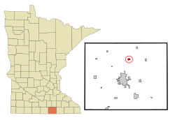
Freeborn County Minnesota Incorporated and Unincorporated areas Clarks Grove Highlighted.svg
Location of Clarks Grove, Minnesota
Coordinates: 43°45′42″N93°19′43″W / 43.76167°N 93.32861°W / 43.76167; -93.32861
Country United States
State Minnesota
County Freeborn
Area
[1]
  Total0.64 sq mi (1.65 km2)
  Land0.60 sq mi (1.55 km2)
  Water0.04 sq mi (0.10 km2)
Elevation
[2]
1,303 ft (397 m)
Population
 (2020)
  Total694
  Density1,158.60/sq mi (447.41/km2)
Time zone UTC-6 (Central (CST))
  Summer (DST) UTC-5 (CDT)
ZIP code
56016
Area code 507
FIPS code 27-11674 [3]
GNIS feature ID2393539 [2]

Clarks Grove is a city in Freeborn County, Minnesota, United States. The population was 706 at the 2010 census. [4]

Contents

History

Clarks Grove was laid out in 1890, about ten years before the railroad was extended to that point. [5] It was incorporated as a village on February 27, 1920, and had a station of the Chicago and Northwestern Railway, sometimes listed as James. Its post office began in 1857 with Clark as postmaster.

Clarks Grove Cooperative Creamery, founded in 1890 by Danish American farmers, was one of the first successful cooperative creameries in the state. [6]

In March 2017, buildings in the community were damaged by a tornado. [7]

Geography

According to the United States Census Bureau, the city has a total area of 0.59 square miles (1.53 km2), of which 0.55 square miles (1.42 km2) is land and 0.04 square miles (0.10 km2) is water. [8] Clarks Grove is along Interstate 35, State Highway 251 (MN 251), and County Roads 31 and 45.

Demographics

Historical population
CensusPop.Note
1930 180
1940 20312.8%
1950 25425.1%
1960 35339.0%
1970 48036.0%
1980 62029.2%
1990 6758.9%
2000 7348.7%
2010 706−3.8%
2020 694−1.7%
U.S. Decennial Census [9]

2010 census

As of the census [10] of 2010, there were 706 people, 295 households, and 197 families living in the city. The population density was 1,283.6 inhabitants per square mile (495.6/km2). There were 312 housing units at an average density of 567.3 per square mile (219.0/km2). The racial makeup of the city was 93.9% White, 0.6% African American, 0.4% Native American, 0.4% Asian, 2.4% from other races, and 2.3% from two or more races. Hispanic or Latino of any race were 6.8% of the population.

There were 295 households, of which 31.2% had children under the age of 18 living with them, 50.8% were married couples living together, 8.5% had a female householder with no husband present, 7.5% had a male householder with no wife present, and 33.2% were non-families. 28.5% of all households were made up of individuals, and 8.8% had someone living alone who was 65 years of age or older. The average household size was 2.39 and the average family size was 2.90.

The median age in the city was 38.1 years. 25.4% of residents were under the age of 18; 8.4% were between the ages of 18 and 24; 24.4% were from 25 to 44; 27.6% were from 45 to 64; and 14.3% were 65 years of age or older. The gender makeup of the city was 50.6% male and 49.4% female.

2000 census

As of the census [3] of 2000, there were 734 people, 283 households, and 206 families living in the city. The population density was 1,717.4 inhabitants per square mile (663.1/km2). There were 296 housing units at an average density of 692.6 per square mile (267.4/km2). The racial makeup of the city was 98.50% White, 0.27% Asian, 0.95% from other races, and 0.27% from two or more races. Hispanic or Latino of any race were 5.31% of the population.

There were 283 households, out of which 39.2% had children under the age of 18 living with them, 59.0% were married couples living together, 10.2% had a female householder with no husband present, and 27.2% were non-families. 24.0% of all households were made up of individuals, and 10.6% had someone living alone who was 65 years of age or older. The average household size was 2.59 and the average family size was 3.04.

In the city, the population was spread out, with 29.0% under the age of 18, 7.9% from 18 to 24, 29.6% from 25 to 44, 20.0% from 45 to 64, and 13.5% who were 65 years of age or older. The median age was 35 years. For every 100 females, there were 103.9 males. For every 100 females age 18 and over, there were 104.3 males.

The median income for a household in the city was $40,179, and the median income for a family was $47,000. Males had a median income of $33,542 versus $20,000 for females. The per capita income for the city was $16,491. About 3.6% of families and 6.7% of the population were below the poverty line, including 5.8% of those under age 18 and 7.7% of those age 65 or over.
Related Research Articles

<span class="mw-page-title-main">Ham Lake, Minnesota</span> City in Minnesota, United States

Ham Lake is a city in Anoka County, Minnesota, United States. It is a suburb in the Minneapolis–Saint Paul metropolitan area. The population was 15,296 at the 2010 census. It is in the Anoka-Hennepin School District, one of Minnesota's largest school districts.

<span class="mw-page-title-main">Oak Grove, Minnesota</span> City in Minnesota, United States

Oak Grove is a city in Anoka County, Minnesota, United States. It is north of Minneapolis. The population was 8,929 at the 2020 census.

<span class="mw-page-title-main">Watertown, Minnesota</span> City in Minnesota, United States

Watertown is a small city in Carver County, Minnesota, United States, along the South Fork of the Crow River, on the outskirts of the Twin Cities metro area. The population was 4,659 at the 2020 census.

<span class="mw-page-title-main">Westbrook, Minnesota</span> City in Minnesota, United States

Westbrook is a city in Cottonwood County, Minnesota, United States. The population was 758 at the 2020 census.

<span class="mw-page-title-main">Hayfield, Minnesota</span> City in Minnesota, United States

Hayfield is a city in Dodge County, Minnesota, United States. The population was 1,340 at the 2010 census.

<span class="mw-page-title-main">Easton, Minnesota</span> City in Minnesota, United States

Easton is a city in Faribault County, Minnesota, United States. The population was 199 at the 2010 census.

<span class="mw-page-title-main">Corcoran, Minnesota</span> City in Minnesota, United States

Corcoran is a rural city in Hennepin County, Minnesota, United States. The population was 5,379 at the 2010 census.

<span class="mw-page-title-main">Spring Grove, Minnesota</span> City in Minnesota, United States

Spring Grove is a city in Houston County, Minnesota, United States. The population was 1,330 at the 2010 census. It is part of the La Crosse-Onalaska, WI-MN Metropolitan Statistical Area.

<span class="mw-page-title-main">Atwater, Minnesota</span> City in Minnesota, United States

Atwater is a city in Kandiyohi County, Minnesota, United States. The population was 1,124 at the 2020 census.

<span class="mw-page-title-main">Truman, Minnesota</span> City in Minnesota, United States

Truman is a city in Martin County, Minnesota, United States. The population was 1,092 at the 2020 census.

<span class="mw-page-title-main">Grove City, Minnesota</span> City in Minnesota, United States

Grove City is a city in Meeker County, Minnesota, United States. The population was 624 at the 2020 census.

<span class="mw-page-title-main">Revere, Minnesota</span> City in Minnesota, United States

Revere is a city in Redwood County, Minnesota, United States. The population was 89 at the 2020 census.

<span class="mw-page-title-main">Greenwald, Minnesota</span> City in Minnesota, United States

Greenwald is a city in Stearns County, Minnesota, United States. The population was 222 at the 2010 census. It is part of the St. Cloud Metropolitan Statistical Area.

Grove Township is a township in Stearns County, Minnesota, United States. The population was 493 at the 2010 census. The township includes the southern one-third of the City of Melrose and the City of Greenwald.

<span class="mw-page-title-main">Bertha, Minnesota</span> City in Minnesota, United States

Bertha is a city in Todd County, Minnesota, United States. The population was 497 at the 2010 census. By the time of the 2020 Decennial Census the population had grown to 560 residents.

<span class="mw-page-title-main">Cottage Grove, Minnesota</span> City in Minnesota, United States

Cottage Grove is a city 10 miles (16 km) south of Saint Paul in Washington County in the State of Minnesota. It lies on the north bank of the Mississippi River, north of the confluence with the St. Croix River. Cottage Grove and nearby suburbs form the southeast portion of Minneapolis-Saint Paul, the 16th-largest metropolitan area in the United States, with about 3.69 million residents. Its population was 38,839 at the 2020 census.

<span class="mw-page-title-main">Oakdale, Minnesota</span> City in Minnesota, United States

Oakdale is a city in Washington County, Minnesota, United States. It is a suburb of Saint Paul and is on the eastern side of the Twin Cities Metropolitan area. The population was 28,303 at the 2020 census. Oakdale is the 36th largest city in Minnesota by population.

<span class="mw-page-title-main">Barnesville, Minnesota</span> City in Minnesota, United States

Barnesville is a city in Clay County, Minnesota, United States. The population was 2,759 at the 2020 census.

<span class="mw-page-title-main">Herman, Minnesota</span> City in Minnesota, United States

Herman is a city in Grant County, Minnesota, United States. The population was 437 at the 2010 census.

<span class="mw-page-title-main">Meire Grove, Minnesota</span> City in Minnesota, United States

Meire Grove is a city in Stearns County, Minnesota, United States. The population was 179 at the 2010 census. It is part of the St. Cloud Metropolitan Statistical Area.

References

  1. "2020 U.S. Gazetteer Files". United States Census Bureau. Retrieved July 24, 2022.
  2. 1 2 U.S. Geological Survey Geographic Names Information System: Clarks Grove, Minnesota
  3. 1 2 "U.S. Census website". United States Census Bureau . Retrieved January 31, 2008.
  4. "2010 Census Redistricting Data (Public Law 94-171) Summary File". American FactFinder. United States Census Bureau . Retrieved April 27, 2011.[ dead link ]
  5. Upham, Warren (1920). Minnesota Geographic Names: Their Origin and Historic Significance. Minnesota Historical Society. p.  200.
  6. Clarks Grove Cooperative Creamery, MNopedia, Minnesota Historical Society.
  7. Sederstrom, Noel (March 7, 2017). "UPDATE: NWS concludes it was a tornado that hit Clarks Grove". KTTC . Retrieved March 7, 2017.
  8. "US Gazetteer files 2010". United States Census Bureau. Archived from the original on January 25, 2012. Retrieved November 13, 2012.
  9. "Census of Population and Housing". Census.gov. Retrieved June 4, 2015.
  10. "U.S. Census website". United States Census Bureau . Retrieved November 13, 2012.