
Breathitt County is a county located in the eastern portion of the U.S. state of Kentucky. As of the 2020 census, the population was 13,718. Its county seat is Jackson. The county was formed in 1839 and was named for John Breathitt, who was Governor of Kentucky from 1832 to 1834. Breathitt County was formerly a dry county, until a public vote in July 2016 passed, allowing alcohol sales.

Chartiers Township is a township in Washington County, Pennsylvania, United States. The population was 8,628 at the 2020 census. Along with the borough of Houston, the township makes up the Chartiers-Houston School District. It is part of the Pittsburgh metropolitan area.

Longview is a city in Cowlitz County, Washington, United States. It is the principal city of the Longview, Washington Metropolitan Statistical Area, which encompasses all of Cowlitz County. Longview's population was 37,818 at the time of the 2020 census, making it the most populous city in Cowlitz County. The city is located in southwestern Washington, at the junction of the Cowlitz and Columbia rivers. Longview shares a border with Kelso to the east, which is the county seat.

Newcastle is an Eastside city in King County, Washington, United States. The population was 13,017 at the 2020 census.

Alum Creek is a census-designated place (CDP) in Kanawha and Lincoln counties along the Coal River in the U.S. state of West Virginia. It includes the unincorporated communities of Alum Creek, Forks of Coal, and Priestley. The CDP had a population of 1,749 at the 2010 census, down from 1,839 at the 2000 census.
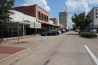
Longview is a city in, and county seat of, Gregg County, Texas, United States. Longview is located in East Texas, where Interstate 20 and U.S. highways 80 and 259 converge just north of the Sabine River. According to the 2020 U.S. census, the city had a population of 81,638. Longview is the principal city of the Longview metropolitan statistical area, comprising Gregg, Upshur, and Rusk counties. The population of the metropolitan area as of 2021 census estimates was 287,858.
Longview or Long view may refer to:
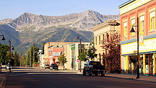
Fernie is a city in the Elk Valley area of the East Kootenay region of southeastern British Columbia, Canada, located on BC Highway 3 on the western approaches to the Crowsnest Pass through the Rocky Mountains. Founded in 1898 and incorporated as the City of Fernie in July 1904, the municipality has a population of over 5,000 with an additional 2,000 outside city limits in communities under the jurisdiction of the Regional District of East Kootenay. A substantial seasonal population swells the city during the winter months.

The Cowlitz River is a river in the state of Washington in the United States, a tributary of the Columbia River. Its tributaries drain a large region including the slopes of Mount Rainier, Mount Adams, and Mount St. Helens.

Northeast Texas is a cultural and geographic region in the northeast corner of the U.S. state of Texas. Geographically centered on two metropolitan areas strung along Interstate 20—Tyler in the west and Kilgore, Longview, Marshall to the east, the areas of Greenville, Mount Pleasant, Sulphur Springs, Paris, and Texarkana in the north primarily along Interstate 30, and Jacksonville and Palestine to the south are also major cities within the region. Most of Northeast Texas is included in the interstate region of the Ark-La-Tex.

R. A. Long High School is the oldest high school serving the city of Longview, Washington. A part of Longview Public Schools, it was erected in 1927, three years after the city of Longview was incorporated. The total student enrollment at the end of the 2015–2016 school year was 890. The school is named for the city's founder, Robert A. Long, a wealthy timber baron from Missouri. Their mascot, the Lumberjack, was so named due to the area's reliance on the timber industry. The female students and sports teams are referred to as "Lumberjills." The school is on the city Historical Register, with the following inscription:
"This school, a gift to the City of Longview by Robert A. Long, was designed by William B. Ittner. The two story Corinthian columns and clock tower dominates the Georgian Revival style. The 900-seat auditorium serves as an educational and cultural center. The building and grounds are listed on the National Register of Historic Places."

Metropolitan Community College is a public community college system in the U.S. state of Missouri. The system consists of four physical campuses in Kansas City, Independence, and Lee's Summit, as well as the MCC-Online campus. The campuses had a total enrollment of 13,376 for the fall semester of 2023. The college's athletic teams are known as the Wolves. It is not affiliated with Metropolitan Community College in Omaha, Nebraska.
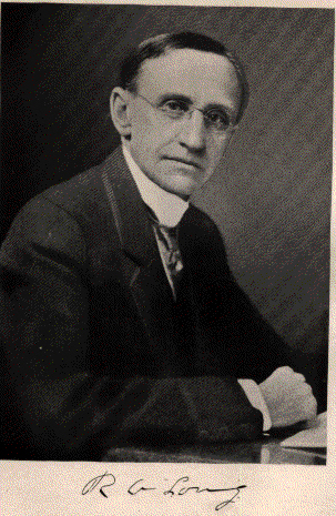
Robert Alexander Long was an American lumber baron, developer, investor, newspaper owner, and philanthropist. He lived most of his life in Kansas City, Missouri and founded Longview, Washington and Longville, Louisiana.

Lower Columbia College (LCC) is a public community college in Longview, Washington. LCC offers associate degree programs along with some bachelor degree programs and certification courses. In the 2023-2024 year, LCC awarded 66 certificates, 491 associate degrees, and 5 Bachelor in Applied Science (BAS) degrees.

Longview High School is a public high school located in the city of Longview, Texas, in Gregg County, United States and classified as a 6A school by the UIL. It is a part of the Longview Independent School District located in eastern Gregg County. The school was founded in 1874 as the Longview Male and Female Institute, and the first permanent structure was established in 1885. In 2017, the school earned 7-out-of-7 distinctions from the Texas Education Agency.
Stella is an unincorporated community in Cowlitz County, Washington. Stella is located northwest of the city of Longview, reached by traveling westbound out of the city along Washington State Route 4, also known as Ocean Beach Highway, and turning north onto Stella Road. The Stella community is part of the Longview School District, a K-12 school district of about 6,600 students.
Oak Point, also known as Oakpoint, is an unincorporated community in Cowlitz County, Washington. Oak Point is located northwest of the city of Longview, reached by traveling westbound out of the city along Washington State Route 4, also known as Ocean Beach Highway, and turning north onto Mill Creek Road. The Oak Point community is part of the Longview School District, a K-12 school district of about 6,600 students.
Bunker Hill is an unincorporated community in Cowlitz County, Washington, United States. Bunker Hill is located northwest of the city of Longview, reached by traveling westbound out of the city along Washington State Route 4, also known as Ocean Beach Highway, and turning north onto Bunker Hill Road. The Bunker Hill community is part of the Longview School District, a K-12 school district of about 6,600 students.
Eufaula is an unincorporated community in Cowlitz County, Washington. Eufaula is located northwest of the city of Longview, reached by traveling westbound out of the city along Washington State Route 4, also known as Ocean Beach Highway, turning north onto Coal Creek Road and then Harmony Drive.

The Mosquito and Coal Creek logging railroad was a 10 miles long private logging railway with a gauge of 3 foot (914 mm) near Eufaula, Washington.


