
Pleasant Hill is a city in Contra Costa County, California, United States, in the East Bay of the San Francisco Bay Area. The population was 34,613 at the 2020 census. It was incorporated in 1961. Pleasant Hill is the home of College Park High School, Diablo Valley College, the Pleasant Hill Library of the Contra Costa County Library system, and the Pleasant Hill Recreation & Park District.

Seat Pleasant is an incorporated city in Prince George's County, Maryland, United States, located immediately east of Washington D.C.. Per the 2020 census, the population was 4,522. Two state highways pass through the community — Maryland routes 704 and 214. The Washington Metro's Blue and Silver Lines are nearby. The Washington Commanders' stadium is east of Seat Pleasant, near the Capital Beltway (I-95/495).

Kelso is a city in the southwestern part of the U.S. state of Washington and is the county seat of Cowlitz County. At the 2020 census, the population was 12,720. Kelso is part of the Longview, Washington Metropolitan statistical area, which has a population of 110,730. Kelso shares its long western border with Longview. It is near Mount St. Helens.

Longview is a city in Cowlitz County, Washington, United States. It is the principal city of the Longview, Washington Metropolitan Statistical Area, which encompasses all of Cowlitz County. Longview's population was 37,818 at the time of the 2020 census, making it the most populous city in Cowlitz County. The city is located in southwestern Washington, at the junction of the Cowlitz and Columbia rivers. Longview shares a border with Kelso to the east, which is the county seat.

Adams Morgan is a neighborhood in Washington, D.C., located in Northwest D.C. Adams Morgan is noted as a historic hub for counterculture and as an arts district. It is also known for its popular entertainment district and culinary scene, centered on both 18th Street and Columbia Road.

Mount Pleasant is a neighborhood in Washington, D.C., located in Northwest D.C. The neighborhood is primarily residential, with restaurants and stores centered along a commercial corridor on Mt. Pleasant Street. Mount Pleasant is known for its unique identity and multicultural landscape, home to diverse groups such as the punk rock, the Peace Corps and Hispanic Washingtonian communities.

Rockridge is a residential neighborhood and commercial district in Oakland, California. Rockridge is generally defined as the area east of Telegraph Avenue, south of the Berkeley city limits, west of the Oakland Hills and north of the intersection of Pleasant Valley Avenue/51st Street and Broadway. Rockridge was listed by Money Magazine in 2002 as one of the "best places to live".
Carrolls is an unincorporated community in Cowlitz County, Washington, south of the city of Kelso. Carrolls is located south on Old Pacific Highway from exit 36 of Interstate 5. The Carrolls community is part of the Kelso School District, a K-12 school district of nearly 5,000 students.
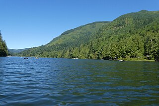
Silver Lake, sometimes Silverlake, is an unincorporated community in Cowlitz County, Washington, in the southwestern portion of the state. Silver Lake is located 6 miles (9.7 km) east of Castle Rock along Washington State Route 504, which is also known as the Spirit Lake Memorial Highway. The area considered Silverlake is about 6 miles (10 km) east of Interstate 5 (I-5) and is approximately 50 miles (80 km) from Portland, Oregon, to the south and Seattle about 110 miles (180 km) to the north. The closest cities to the subject property are Castle Rock, six miles (10 km) to the west, and Toutle, four miles (6 km) east.

WMPH is Delaware's first high school radio station, located in Wilmington. The Brandywine School District Board of Education owns the license granted by the FCC. The call letters WMPH stand for Mount Pleasant High and offered several program formats including Top 40, progressive rock, dance and now classic and alternative music. WMPH signed off the air on June 11, 2010 but has since been totally renovated and came back on-air at full power on June 3, 2011 in a classic/alternative rock, jazz and community based format.

Lower Columbia College (LCC) is a public community college in Longview, Washington. LCC offers associate degree programs along with some bachelor degree programs and certification courses. In the 2023-2024 year, LCC awarded 66 certificates, 491 associate degrees, and 5 Bachelor in Applied Science (BAS) degrees.

The George and Sarah Joslyn Home, is a mansion located at 3902 Davenport Street in the Gold Coast Historic District of Omaha, Nebraska, United States. Built in the Scottish Baronial style in 1903, the Castle was added to the National Register of Historic Places in 1972. It was designated as an Omaha landmark in 1979.

State Route 411 (SR 411) is a 13.48-mile (21.69 km) state highway located in Cowlitz County in the U.S. state of Washington, serving Longview, Kelso, West Side Highway and Castle Rock. The roadway, which parallels the Cowlitz River and Interstate 5 (I-5), begins at an interchange with SR 432 in Longview and travels north past a spur route, under SR 4 and across the Cowlitz River to become concurrent with I-5 Business and end at an interchange with I-5, I-5 Business and SR 504 in Castle Rock. The road first appeared on a map in 1951 and originally signed as Secondary State Highway 12H (SSH 12H) in 1957, SR 411 was established in 1964 and ran from Kelso to Vader. In 1991, the highway was extended south to SR 432 in Longview, the former route becoming SR 411 Spur, and was shortened to I-5 / I-5 Business / SR 504 in Castle Rock.

Lawrence County is a county in the Commonwealth of Pennsylvania. As of the 2020 census, the population was 86,070. The county seat and largest city is New Castle.
Toutle is an unincorporated community in Cowlitz County, Washington.
Ostrander is an unincorporated community in Cowlitz County, Washington, north of the city of Kelso. Ostrander is located north on North Pacific Avenue from exit 42 of Interstate 5. The Ostrander community is part of the Kelso School District, a K-12 school district of nearly 5,000 students.
Rose Valley is an unincorporated community in Cowlitz County, Washington, southeast of the city of Kelso. Rose Valley is located south on Old Pacific Highway from exit 36 of Interstate 5, then east on Rose Valley Road. The Rose Valley community is part of the Kelso School District, a K-12 school district of nearly 5,000 students.
Sandy Bend is an unincorporated community in Cowlitz County, Washington, south of the city of Castle Rock, west of Washington State Route 411, and to the west of the Cowlitz River. Sandy Bend is located along or near Sandy Bend Road between Castle Rock and West Side Highway. The Sandy Bend community is part of the Castle Rock School District, a K-12 school district of about 1,300 students.
Olequa, also known as Olequah, is an unincorporated community in Cowlitz County, Washington. Olequa is located north of the city of Castle Rock on the west bank of the Cowlitz River. Olequa is accessed by traveling 7.5 miles (12.1 km) north on West Side Highway from Castle Rock. The Olequa community is part of the Castle Rock School District, a K-12 school district of about 1,300 students.


