Sightly, Washington | |
---|---|
Unincorporated community | |
Coordinates: 46°17′59″N122°42′30″W / 46.29972°N 122.70833°W Coordinates: 46°17′59″N122°42′30″W / 46.29972°N 122.70833°W | |
Country | |
State | |
County | Cowlitz |
Elevation [1] | 211 m (692 ft) |
Time zone | PST (UTC−8) |
• Summer (DST) | PDT (UTC−7) |
ZIP code | 98649 |
Area code(s) | 360 |
FIPS code | 53-64155 |
GNIS feature ID | 1511313 |
Sightly is an unincorporated community in Cowlitz County, Washington. Sightly is located east of the city of Castle Rock and east of Silver Lake. Sightly is reached by taking exit 49 off of Interstate 5, traveling 10.4 miles (16.7 km) east along Washington State Route 504, which is also known as the Spirit Lake Memorial Highway, [2] and then traveling 2.4 miles (3.9 km) along Sightly Road. The Sightly community was given its name due to its views of Mount St. Helens. The Sightly community is part of the Toutle Lake School District, a K-12 school district of about 600 students.
In law, an unincorporated area is a region of land that is not governed by a local municipal corporation; similarly an unincorporated community is a settlement that is not governed by its own local municipal corporation, but rather is administered as part of larger administrative divisions, such as a township, parish, borough, county, city, canton, state, province or country. Occasionally, municipalities dissolve or disincorporate, which may happen if they become fiscally insolvent, and services become the responsibility of a higher administration. Widespread unincorporated communities and areas are a distinguishing feature of the United States and Canada. In most other countries of the world, there are either no unincorporated areas at all, or these are very rare; typically remote, outlying, sparsely populated or uninhabited areas.
Cowlitz County is a county located in the U.S. state of Washington. As of the 2010 census, its population was 102,410. The county seat is Kelso, and its largest city is Longview. The county was formed in April 1854. Its name derives from the anglicized version of the Cowlitz Indian term, Cow-e-liske, meaning either "river of shifting sands" or "capturing the medicine spirit."
Castle Rock is a city in Cowlitz County, Washington, United States. Located between the Willapa Hills and western base of Mount St. Helens, Castle Rock is at the heart of Washington timber country in the Pacific temperate rain forest. Castle Rock is part of the Longview, Washington Metropolitan Statistical Area; the population was 1,982 as of the 2010 census.
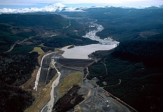
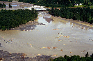
Sightly is located 25.7 miles (41.4 km) northwest of Mount St. Helens. The eruption of Mount St. Helens on May 18, 1980, was the deadliest and most economically destructive volcanic event in the history of the United States.
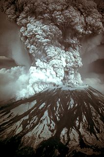
On May 18, 1980, a major volcanic eruption occurred at Mount St. Helens, a volcano located in Skamania County, in the U.S. state of Washington. The eruption was the most significant volcanic eruption to occur in the contiguous 48 U.S. states since the much smaller 1915 eruption of Lassen Peak in California. It has often been declared as the most disastrous volcanic eruption in U.S. history. The eruption was preceded by a two-month series of earthquakes and steam-venting episodes, caused by an injection of magma at shallow depth below the volcano that created a large bulge and a fracture system on the mountain's north slope.
The United States of America (USA), commonly known as the United States or America, is a country composed of 50 states, a federal district, five major self-governing territories, and various possessions. At 3.8 million square miles, the United States is the world's third or fourth largest country by total area and is slightly smaller than the entire continent of Europe's 3.9 million square miles. With a population of over 327 million people, the U.S. is the third most populous country. The capital is Washington, D.C., and the largest city by population is New York. Forty-eight states and the capital's federal district are contiguous in North America between Canada and Mexico. The State of Alaska is in the northwest corner of North America, bordered by Canada to the east and across the Bering Strait from Russia to the west. The State of Hawaii is an archipelago in the mid-Pacific Ocean. The U.S. territories are scattered about the Pacific Ocean and the Caribbean Sea, stretching across nine official time zones. The extremely diverse geography, climate, and wildlife of the United States make it one of the world's 17 megadiverse countries.
Sightly is located at 46°17′59″N122°42′30″W / 46.29972°N 122.70833°W (46.2998338, -122.7084437). [3]
The Cowlitz River is a river in the state of Washington in the United States, a tributary of the Columbia River. Its tributaries drain a large region including the slopes of Mount Rainier, Mount Adams, and Mount St. Helens.
The North Fork Toutle River is a tributary of the Toutle River in southwestern Washington in the United States. The river has its headwaters near Spirit Lake, on the north side of Mount St. Helens, and flows 39 miles (63 km) to the Toutle River, about 17 miles (27 km) upstream of its confluence with the Cowlitz River. The largest tributary is the Green River, which joins near the unincorporated town of Toutle.
State Route 504 is a state highway in southwestern Washington state in the United States. It travels 52 miles (84 km) along the North Fork Toutle River to the Mount St. Helens area, serving as the main access to the Mount St. Helens National Volcanic Monument. The highway begins at an interchange with Interstate 5 (I-5) and SR 411 in Castle Rock and terminates at the Johnston Ridge Observatory near Spirit Lake.
Cougar is an unincorporated community and former town in Cowlitz County, Washington, northeast of the city of Woodland. Cougar is located 29 miles (47 km) northeast of Woodland along Washington State Route 503 and situated along the northwest bank of Yale Lake, a reservoir on the Lewis River. The population was 122 at the 1990 Census, when it was still incorporated as a town, but disincorporated before the 2000 Census. The Cougar community is part of the Woodland School District, a K-12 school district of about 2,200 students. Cougar is the nearest community to Mount St. Helens, which lies 13 miles (20.9215 km) to its northeast. The eruption of Mount St. Helens on May 18, 1980 was the deadliest and most economically destructive volcanic event in the history of the United States.
Yale is an unincorporated community in Cowlitz County, Washington, northeast of the city of Woodland. Yale is located 22.4 miles (36.0 km) northeast of Woodland along Washington State Route 503 and situated between Yale Lake and Lake Merwin, both reservoirs on the Lewis River. The rock-fill hydro-electric Yale Dam is nearby. Named for Yale University, the only school teaching forestry in the 19th century, the Yale community is part of the Woodland School District, a K-12 school district of about 2,200 students.
The Toutle River is a 17.2-mile (27.7 km) tributary of the Cowlitz River in the U.S. state of Washington. It rises in two forks merging near Toutle below Mount St. Helens and joins the Cowlitz near Castle Rock, 20 miles (32 km) upstream of the larger river's confluence with the Columbia River.
Silver Lake, sometimes Silverlake, is an unincorporated community in Cowlitz County, Washington, in the southwestern portion of the state. Silver Lake is located 6 miles (9.7 km) east of Castle Rock along Washington State Route 504, which is also known as the Spirit Lake Memorial Highway. The area considered Silverlake is about 6 miles (10 km) east of Interstate 5 (I-5) and is approximately 50 miles (80 km) from Portland, Oregon, to the south and Seattle about 110 miles (180 km) to the north. The closest cities to the subject property are Castle Rock, six miles (10 km) to the west, and Toutle, four miles (6 km) east.
St. Helens, alternatively titled St. Helens, Killer Volcano, is a 1981 made-for-cable HBO television film directed by Ernest Pintoff and starring David Huffman, Art Carney, Cassie Yates, and Albert Salmi. The film centers on the events leading up to the cataclysmic 1980 eruption of Mount St. Helens in Washington, with the story beginning on the day volcanic activity started on March 20, 1980, and ending on the day of the eruption, May 18, 1980. The film premiered on May 18, 1981, on the first anniversary of the eruption.
Toutle is an unincorporated community in Cowlitz County, Washington. Toutle is located 10 miles (16 km) east of Castle Rock along Washington State Route 504, which is also known as the Spirit Lake Memorial Highway. The Toutle community, similar to Toutle River, takes its name from the Hullooetell, a band of the Skillot - a Chinookan tribe. The Toutle community is part of the Toutle Lake School District, a K-12 school district of about 720 students that serves the communities of Toutle and Silver Lake, Washington. Toutle is near Mount St. Helens and the Mount St. Helens National Volcanic Monument, which lies at the end of the Spirit Lake Memorial Highway. The eruption of Mount St. Helens on May 18, 1980 was the deadliest and most economically destructive volcanic event in the history of the United States.
Headquarters is an unincorporated community in Cowlitz County, Washington, southeast of the city of Castle Rock. The Headquarters community is split between the Castle Rock School District, the Kelso School District and the Toutle Lake School District.
Harrington Place, also known as Herrington Place, is an unincorporated community in Cowlitz County, Washington. Harrington Place is located east of the city of Castle Rock and along the South Fork Toutle River. Harrington Place is accessed by about 19 miles (31 km) of logging roads off of Washington State Route 504, also known as the Spirit Lake Memorial Highway, after reaching the community of Toutle while traveling eastbound. The Harrington Place community is part of the Kelso School District, a K-12 school district of nearly 5,000 students.
Woodland Park is an unincorporated community in Cowlitz County, Washington. The Woodland Park community is located 17 miles (27 km) northeast of Woodland along Washington State Route 503 and on the north shore of Lake Merwin, a reservoir on the Lewis River. The Woodland Park community is part of the Woodland School District, a K-12 school district of about 2,200 students.
Saint Helens is an unincorporated community in Cowlitz County, Washington. Saint Helens is located east of the city of Castle Rock and along the North Fork Toutle River. Saint Helens is reached by traveling 24 miles (39 km) east of Castle Rock along Washington State Route 504, which is also known as the Spirit Lake Memorial Highway. The Saint Helens community takes its name from Mount St. Helens, which, in turn, was named by explorer George Vancouver after a friend of his, Baron St. Helens. The Saint Helens community is part of the Toutle Lake School District, a K-12 school district of about 600 students.
Kid Valley is an unincorporated community in Cowlitz County, Washington. Kid Valley is located east of the city of Castle Rock and along the North Fork Toutle River. Kid Valley is reached by traveling 17.8 miles (28.6 km) east of Castle Rock along Washington State Route 504, which is also known as the Spirit Lake Memorial Highway. The Kid Valley community is part of the Toutle Lake School District, a K-12 school district of about 600 students.
Pigeon Springs is an unincorporated community in Cowlitz County, Washington. Pigeon Springs is located east of the city of Kalama and along the Kalama River. Pigeon Springs is reached by traveling 16.8 miles (27.0 km) east on Kalama River Road from exit 32 of Interstate 5. The Pigeon Springs community is part of the Kalama School District, a K-12 school district of about 900 students.
Coldwater Lake is a barrier lake on the border of Cowlitz County and Skamania County, Washington in the United States. The lake was created during the 1980 eruption of Mount St. Helens, which blocked its natural outlet, Coldwater Creek, with volcanic debris. It is one of several lakes in the area that were created or otherwise enlarged by the eruption.
Castle Creek is a tributary of the North Fork Toutle River on the flank of Mount St. Helens in Washington State. It rises about two miles (three kilometers) northwest of the crater rim and flows generally to the northwest. The outflow of Castle Lake joins the creek at the lake's north end after traveling a few hundred meters on the South Fork Castle Creek. It joins the North Fork Toutle River at 46.28302°N 122.29359°W, elevation 2,200 feet.
This Cowlitz County, Washington state location article is a stub. You can help Wikipedia by expanding it. |