
Mount St. Helens is an active stratovolcano located in Skamania County, Washington, in the Pacific Northwest region of the United States. It lies 52 miles (83 km) northeast of Portland, Oregon, and 98 miles (158 km) south of Seattle. Mount St. Helens takes its English name from that of the British diplomat Alleyne Fitzherbert, 1st Baron St Helens, a friend of explorer George Vancouver who surveyed the area in the late 18th century. The volcano is part of the Cascade Volcanic Arc, a segment of the Pacific Ring of Fire.

Castle Rock is a city in Cowlitz County, Washington, United States. Located between the Willapa Hills and the western base of Mount St. Helens, Castle Rock is at the heart of Washington timber country in the Pacific temperate rain forest. Castle Rock is part of the Longview, Washington Metropolitan Statistical Area; the population was 2,446 as of the 2020 census.

The Cowlitz River is a river in the state of Washington in the United States, a tributary of the Columbia River. Its tributaries drain a large region including the slopes of Mount Rainier, Mount Adams, and Mount St. Helens.

On March 27, 1980, a series of volcanic explosions and pyroclastic flows began at Mount St. Helens in Skamania County, Washington, United States. A series of phreatic blasts occurred from the summit and escalated until a major explosive eruption took place on May 18, 1980, at 8:32 am. The eruption, which had a volcanic explosivity index of 5, was the first to occur in the contiguous United States since the much smaller 1915 eruption of Lassen Peak in California. It has often been considered the most disastrous volcanic eruption in U.S. history.

Spirit Lake is a lake in Skamania County, Washington, United States, located north of Mount St. Helens. It was a popular tourist destination for many years until Mount St. Helens erupted in 1980. Previously there had been six camps on the shore of Spirit Lake: Boy Scout, the Girl Scout Camp at Spirit Lake, two YMCA camps, Harmony Fall Lodge, and another for the general public. There were also several lodges accessible to visitors, including Spirit Lake Lodge and Mt. St. Helens Lodge. The latter was owned and operated by Harry R. Truman, a noted victim of the volcano's 1980 eruption.

Mount St. Helens National Volcanic Monument is a U.S. National Monument that includes the area around Mount St. Helens in Cowlitz and Skamania Counties, Washington. It was established on August 27, 1982, by U.S. President Ronald Reagan, following the 1980 eruption. The 110,000 acre (445 km2) National Volcanic Monument was set aside for research, recreation, and education. Inside the monument, the environment is left to respond naturally to the disturbance. It was the third national monument to be managed by the U.S. Forest Service and is part of the Gifford Pinchot National Forest.
The North Fork Toutle River is a tributary of the Toutle River in southwestern Washington in the United States. The river has its headwaters near Spirit Lake, on the north side of Mount St. Helens, and flows 39 miles (63 km) to the Toutle River, about 17 miles (27 km) upstream of its confluence with the Cowlitz River. The largest tributary is the Green River, which joins near the unincorporated town of Toutle.
State Route 504 is a state highway in southwestern Washington state in the United States. It travels 52 miles (84 km) along the North Fork Toutle River to the Mount St. Helens area, serving as the main access to the Mount St. Helens National Volcanic Monument. The highway begins at an interchange with Interstate 5 (I-5) and SR 411 in Castle Rock and terminates at the Johnston Ridge Observatory near Spirit Lake.
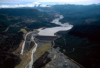
Yale is an unincorporated community in Cowlitz County, Washington, northeast of the city of Woodland. Yale is located 22.4 miles (36.0 km) northeast of Woodland along Washington State Route 503 and situated between Yale Lake and Lake Merwin, both reservoirs on the Lewis River. The rock-fill hydro-electric Yale Dam is nearby. Named for Yale University, the only school teaching forestry in the 19th century, the Yale community is part of the Woodland School District, a K-12 school district of about 2,200 students.
The Toutle River is a 17.2-mile (27.7 km) tributary of the Cowlitz River in the U.S. state of Washington. It rises in two forks merging near Toutle below Mount St. Helens and joins the Cowlitz near Castle Rock, 20 miles (32 km) upstream of the larger river's confluence with the Columbia River.
Silver Lake, sometimes Silverlake, is an unincorporated community in Cowlitz County, Washington, in the southwestern portion of the state. Silver Lake is located 6 miles (9.7 km) east of Castle Rock along Washington State Route 504, which is also known as the Spirit Lake Memorial Highway. The area considered Silverlake is about 6 miles (10 km) east of Interstate 5 (I-5) and is approximately 50 miles (80 km) from Portland, Oregon, to the south and Seattle about 110 miles (180 km) to the north. The closest cities to the subject property are Castle Rock, six miles (10 km) to the west, and Toutle, four miles (6 km) east.
St. Helens is a 1981 made-for-cable HBO television film directed by Ernest Pintoff, and starring David Huffman, Art Carney, Cassie Yates, and Albert Salmi. The film centers on the events leading up to the cataclysmic 1980 eruption of Mount St. Helens in Washington, with the story beginning on the day volcanic activity started on March 20, 1980, and ending on the day of the eruption, May 18, 1980. The film premiered on May 18, 1981, on the first anniversary of the eruption.

State Route 505 (SR 505) is a short state highway in the U.S. state of Washington. It connects the towns of Winlock and Toledo to Interstate 5 (I-5) and SR 504.
The Green River is the largest tributary of the North Fork Toutle River in the U.S. state of Washington. Situated near Mount St. Helens in the Cascade Range in the southern part of the state, it flows generally west through Mount St. Helens National Volcanic Monument and industrial timberlands for 37.4 miles (60.2 km). The river drains more than 130 square miles (340 km2) in parts of three Washington counties: Skamania, Lewis, and Cowlitz.
Kid Valley is an unincorporated community in Cowlitz County, Washington. Kid Valley is located east of the city of Castle Rock and along the North Fork Toutle River. Kid Valley is reached by traveling 17.8 miles (28.6 km) east of Castle Rock along Washington State Route 504, which is also known as the Spirit Lake Memorial Highway. The Kid Valley community is part of the Toutle Lake School District, a K-12 school district of about 600 students.
Sightly is an unincorporated community in Cowlitz County, Washington. Sightly is located east of the city of Castle Rock and east of Silver Lake. Sightly is reached by taking exit 49 off of Interstate 5, traveling 10.4 miles (16.7 km) east along Washington State Route 504, which is also known as the Spirit Lake Memorial Highway, and then traveling 2.4 miles (3.9 km) along Sightly Road. The Sightly community was given its name due to its views of Mount St. Helens. The Sightly community is part of the Toutle Lake School District, a K-12 school district of about 600 students.

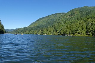
Coldwater Lake is a barrier lake on the border of Cowlitz County and Skamania County, Washington in the United States. The lake was created during the 1980 eruption of Mount St. Helens, which blocked its natural outlet, Coldwater Creek, with volcanic debris. It is one of several lakes in the area that were created or otherwise enlarged by the eruption.

Coldwater Peak is a 5,722 ft (1,740 m) mountain summit located in Mount St. Helens National Volcanic Monument, in the Gifford Pinchot National Forest, in Skamania County of southwest Washington state. It is situated in the Cascade Range, 2 mi (3.2 km) northwest of Spirit Lake, and 2 mi (3.2 km) east of Coldwater Lake. Its nearest higher neighbor is Mount Margaret, 2.4 mi (3.9 km) to the northeast, and Mount St. Helens rises 7 mi (11 km) to the south. Precipitation runoff from Coldwater Peak drains into Coldwater Creek, a tributary of the North Fork Toutle River. The mountain takes its name from this creek, and was officially adopted in 1983 by the U.S. Board on Geographic Names. A trail provides access to the summit, the site of the former Coldwater Lookout from 1935 to 1968, and now is a site for research instruments.

Mount Whittier is a prominent 5,883-ft mountain summit located in Mount St. Helens National Volcanic Monument, in the Gifford Pinchot National Forest, in Skamania County of southwest Washington state. It is situated in the Cascade Range, 2 mi (3.2 km) north of Spirit Lake, and 1.7 mi (2.7 km) northeast of The Dome. Its closest neighbor is Mount Margaret, 0.93 mi (1.50 km) to the south, and the nearest higher neighbor is Mount St. Helens, 9 mi (14 km) to the south. Whittier is the second-highest peak in the Mount St. Helens area, after Mt. St. Helens. Although modest in elevation, relief is significant as the summit rises 2,000 feet above the head of Coldwater Creek valley in 0.6 mi (0.97 km). Precipitation runoff from Mount Whittier drains into tributaries of the North Fork Toutle River.

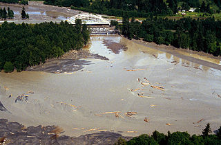
The 2023 South Coldwater Slide is a mudslide that occurred in May 2023 near Mt. St. Helens. The volume of debris, and subsequent destruction of a bridge, closed off Washington State Route 504 and access to the Mount St. Helens National Volcanic Monument.

