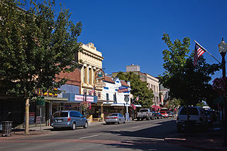
Ryderwood, Washington

Last updated

Ryderwood, Washington
USA Washington location map.svg
Red pog.svg
Ryderwood
Location in the state of Washington
Coordinates: 46°22′N123°3′W / 46.367°N 123.050°W / 46.367; -123.050
Country United States
State Washington
County Cowlitz
Area
[1]
  Total0.16 sq mi (0.42 km2)
  Land0.16 sq mi (0.42 km2)
  Water0.0 sq mi (0.0 km2)
Elevation
[2]
266 ft (81 m)
Population
 (2010) [3]
  Total395 [3]
Time zone UTC−8 (PST)
  Summer (DST) UTC−7 (PDT)
ZIP code
98581
Area code 360
FIPS code 53-60580
GNIS feature ID2586746

Ryderwood is a census-designated place (CDP) in Cowlitz County, Washington, west of the city of Vader. Known locally as the "Village in the Woods", the town began in 1923 as a logging settlement and considered itself the "World's Largest Logging Town". Ryderwood became a retirement community in the 1950s. [4]

Contents

History

20th century

Ryderwood, originally named Cougar Flats, was established as a logging camp by the Long-Bell Lumber Company in 1923. The town was constructed at a cost of $1.5 million and was the largest community to be built by private funding. [4] Simultaneously, the town of Longview was created to mill and ship the lumber coming out of Ryderwood. Ryderwood was named for W. F. ("Uncle Bill") Ryder, the logging operations manager for Long-Bell, who came to the northwest to locate a timber source. The community was envisioned beyond that of a temporary logging camp, as a permanent center that would contain a school, church and theater. Billed as a place for families to live rather than bachelor workers, Ryderwood was considered a "modern logging town", as an article in The Log of Long-Bell proclaimed. [5]

By 1953, due to advances in timber harvesting technology and the loss of old growth timber, Long-Bell sold the town. It was purchased by Senior Estates, Inc. for $96,000 with the goal of creating a retirement community for pensioners. [6] The town built Ryderwood Lake [lower-alpha 1] in 1956, encompassing 6 acres inside an existing gravel pit. [7]

In the 1980s, Ryderwood was home to the beginning of the Winlock Pickersfest, originally a bluegrass festival. The event relocated to Winlock in 2000. [8] As of 2022, the festival continues to be held. [9]

21st century

Ryderwood held a town-wide centennial celebration in 2023. Featuring a pioneer costumed parade, the event included the opening of a time capsule. [4]

Limited water sources have led the town to experience water shortages and rationing during times of drought. The community created the Ryderwood Drought Resiliency project to help create a water storage system and in early 2024, it was granted $1.6 million from the federal government to begin operations for a reservoir. [10]

Geography

According to the United States Census Bureau, the CDP has a total area of 0.16 square miles (0.42 km2), all (100.0%) land.

The town is bordered to the west by Becker Creek and to the east by Campbell Creek and Ryderwood Lake. [11] Campbell Creek is the main water source for the community. [10]

Demographics

Historical population
CensusPop.Note
2010 395
2010 U.S. Census

At the town's peak, the population reached 2,000 people and had over 400 single-family homes. Ryderwood was large enough to have its own hospital. [4]

2010 Census

At the 2010 census, [3] there were 395 people, 221 households and 134 families residing in the CDP. The population density was 2,453.4 per square mile (947.3/km2). There were 266 housing units at an average density of 1,652.2 per square mile (637.9/km2). The racial make-up of the CDP was 97.5% White, 0.3% African American, 1.3% Native American, 0.0% Asian, 0.0% Pacific Islander, 0.3% from other races and 0.8% from two or more races. Hispanic or Latino of any race were 0.8% of the population.

There were 221 households, of which 5.2% had children under the age of 18 living with them, 57.9% were married couples living together, 2.7% had a female householder with no husband present and 39.4% were non-families. 33.0% of all households were made up of individuals, and 26.2% had someone living alone who was 65 years of age or older. The average household size was 1.79 and the average family size was 2.15.

2.5% of the population were under the age of 18, 0.8% from 18 to 24, 2.5% from 25 to 44, 24.3% from 45 to 64 and 69.9% were 65 years of age or older. The median age was 68.7 years. For every 100 females, there were 82.9 males. For every 100 females age 18 and over, there were 84.2 males.

Government

Ryderwood is considered a retirement community and is managed under the auspices of a homeowner's association, the Ryderwood Improvement and Service Association, a non-profit 501(c)4 organization staffed by resident volunteers. [4] [7] [12]

Notable people

Notes

  1. Also known and referred to as Ryderwood Pond.

Related Research Articles

<span class="mw-page-title-main">Lewis County, Washington</span> County in Washington, United States

Lewis County is a county in the U.S. state of Washington. As of the 2020 census, the county's population was 82,149. The county seat is Chehalis, and its largest city is Centralia. Lewis County comprises the Centralia, WA Micropolitan Statistical Area, which is also included in the Seattle-Tacoma, WA Combined Statistical Area.

<span class="mw-page-title-main">Cowlitz County, Washington</span> County in Washington, United States

Cowlitz County is a county located in the U.S. state of Washington. As of the 2020 census, its population was 110,730. The county seat is Kelso, and its largest city is Longview. The county was formed in April 1854. Its name derives from the anglicized version of the Cowlitz Indian term Cow-e-liske, meaning either 'river of shifting sands' or 'capturing the medicine spirit.' Cowlitz comprises the Longview, WA Metropolitan statistical area, which is also included in the Portland-Vancouver-Salem, OR-WA Combined statistical area.

<span class="mw-page-title-main">Brewton, Alabama</span> City in and county seat of Escambia County, Alabama

Brewton is a city in and the county seat of Escambia County, Alabama, United States. As of the 2020 census, the population was 5,276. Brewton is located in south central Alabama, just north of the Florida Panhandle.

<span class="mw-page-title-main">Westwood, California</span> Census-designated place in California, United States

Westwood is a census-designated place (CDP) in Lassen County, California, United States. Westwood is located 20 miles (32 km) west-southwest of Susanville, at an elevation of 5,128 feet. Its population is 1,541 as of the 2020 census, down from 1,647 from the 2010 census..

<span class="mw-page-title-main">Boulder Creek, California</span> Census-designated place in California, United States

Boulder Creek is a small rural mountain community in the coastal Santa Cruz Mountains. It is a census-designated place (CDP) in Santa Cruz County, California, with a population of 5,429 as of the 2020 census. Throughout its history, Boulder Creek has been home to a logging town and a resort community, as well as a counter-culture haven. Today, it is identified as the gateway to Big Basin Redwoods State Park.

<span class="mw-page-title-main">Stearns, Kentucky</span> Census-designated place in Kentucky, United States

Stearns is an unincorporated community and census-designated place (CDP) in McCreary County, Kentucky, United States. The population was 1,365 at the 2020 census. It was founded by Justus Smith Stearns.

<span class="mw-page-title-main">Prudenville, Michigan</span> Census-designated place & unincorporated community in Michigan, United States

Prudenville is an unincorporated community and census-designated place (CDP) in Roscommon County in the U.S. state of Michigan. The population was 1,643 at the 2020 census. Prudenville is located within Denton Township.

<span class="mw-page-title-main">Longview, Washington</span> City in Washington, United States

Longview is a city in Cowlitz County, Washington, United States. It is the principal city of the Longview, Washington Metropolitan Statistical Area, which encompasses all of Cowlitz County. Longview's population was 37,818 at the time of the 2020 census, making it the largest city in Cowlitz County. The city is located in southwestern Washington, at the junction of the Cowlitz and Columbia rivers. Longview shares a border with Kelso to the east, which is the county seat.

<span class="mw-page-title-main">Port Ludlow, Washington</span> Census-designated place in Washington, United States

Port Ludlow is an unincorporated community and census-designated place (CDP) in Jefferson County, Washington, United States. It is also the name of the marine inlet on which the community is located. The CDP's population was 2,603 at the 2010 census, up from 1,968 at the 2000 census.

<span class="mw-page-title-main">Centralia, Washington</span> City in Washington, United States

Centralia is a city in Lewis County, Washington, United States. It is located along Interstate 5 near the midpoint between Seattle and Portland, Oregon. The city had a population of 18,183 at the 2020 census. Centralia is twinned with Chehalis, located to the south near the confluence of the Chehalis and Newaukum rivers.

<span class="mw-page-title-main">Chehalis, Washington</span> City in Washington, United States

Chehalis is a city in and the county seat of Lewis County, Washington, United States. The population was 7,439 at the time of the 2020 census.

<span class="mw-page-title-main">Fords Prairie, Washington</span> Census-designated place in Washington, United States

Fords Prairie is an unincorporated community and census-designated place (CDP) in Lewis County, Washington, United States. The population was 2,234 at the 2020 census.
<span class="mw-page-title-main">Morton, Washington</span> City in Washington, United States

Morton is a city in Lewis County, Washington, United States. The population was 1,036 at the 2020 census.
<span class="mw-page-title-main">Napavine, Washington</span> City in Washington, United States

Napavine is a city in Lewis County, Washington, United States. It is also included in the Centralia, WA micropolitan area. The population was 1,766 at the 2020 census.

<span class="mw-page-title-main">Winlock, Washington</span> City in Washington, United States

Winlock is a city in Lewis County, Washington, United States. The population was 1,472 at the 2020 census. It was named after territorial army general, Winlock M. Miller, who briefly resided there. Winlock is mostly famous for having the World's Largest Egg, reflecting its former status as a major producer of eggs. Early in its history, Winlock attracted many immigrants from Finland, Germany, and Sweden.

<span class="mw-page-title-main">Naselle, Washington</span> Place in Washington, United States

Naselle is a census-designated place (CDP) in Pacific County, Washington, United States located about 23 miles (37 km) from the mouth of the Columbia River. The population was 419 at the 2010 census. The valley's Naselle River flows west into nearby Willapa Bay and then into the Pacific Ocean. Close about the town lie the evergreen-covered Willapa Hills. The river's name has been spelled Nasel and Nasal. An early settler along the river called it the Kenebec. The name comes from the Nisal Indians, a Chinookan tribe formerly residing on the river.

<span class="mw-page-title-main">Cazadero, California</span> Unincorporated community in California, United States

Cazadero is an unincorporated community and census-designated place (CDP) in western Sonoma County, California, United States with a population of 354 in 2010. The downtown of Cazadero consists of two churches, a general store, a post office, a hardware store, an auto repair garage, private office space, and the Cazadero Volunteer Fire Department.

<span class="mw-page-title-main">Packwood, Washington</span> Census-designated place in Washington, United States

Packwood is an unincorporated community and census-designated place (CDP) located in easternmost Lewis County, Washington, in the United States. As of the 2020 census, the CDP had a population of 319, while the town and surrounding Packwood community had a total population of 1,073.

Orin C. Smith was an American businessman who was president and chief executive officer (CEO) of Starbucks Corporation from 2000 to 2005. He joined Starbucks as vice president and chief financial officer in 1990, becoming president and chief operating officer in 1994, and a director of Starbucks in 1996. He was preceded by Howard Shultz and succeeded by Jim Donald who was himself succeeded by Shultz.

<span class="mw-page-title-main">Mineral, Washington</span> Census-designated place in Washington, United States

Mineral is an unincorporated community and census-designated place (CDP) in Lewis County, Washington, on State Route 7 near the Pierce/Lewis county line. Mineral originally began as a logging camp and mining town. Prospectors searching the area for gold instead found coal and arsenic. By the early 1920s, the mines closed, and with a devastating fire to the town's largest sawmill, Mineral began to turn to tourism as its main industry, primarily through recreational fishing on Mineral Lake.

References

  1. "2013 U.S. Gazetteer Files". census.gov. Retrieved 6 June 2014.
  2. "USGS—Ryderwood, Washington" . Retrieved 6 June 2014.
  3. 1 2 3 "U.S. Census website". United States Census Bureau. 2011. Retrieved 6 June 2014.
  4. 1 2 3 4 5 The Chronicle staff (31 July 2023). "The town with two histories: Ryderwood celebrates 100 years". The Chronicle. Retrieved 3 August 2023.
  5. "Crew with logs at loading site, Long Bell Lumber Company, Ryderwood, ca. 1929". Digital Collections. University Libraries, University of Washington. Retrieved 29 September 2019.
  6. Aging. U.S. Government Printing Office. 1951 via Google Books.
  7. 1 2 Fitzgerald, Emily (22 October 2021). "A Blemish on Nature's Beauty: Ryderwood Residents Look to Restore Town's Fishing Pond". The Chronicle. Retrieved 4 November 2021.
  8. Brewer, Christopher (8 July 2014). "Winlock Pickers' Festival Attracts Acoustic Aficionados". The Chronicle (Centralia, Washington). Retrieved 10 January 2023.
  9. Vander Stoep, Isabel (8 August 2022). "Winlock Pickersfest Returns for 20th Year". The Chronicle (Centralia, Washington). Retrieved 10 January 2023.
  10. 1 2 Barber, Caleb (13 March 2024). "Ryderwood gets federal funding for reservoir". The Daily News (Longview, Washington) .
  11. "Ryderwood, WA Map". OpenStreetMap.
  12. "RISA Contact Info". Ryderwood Washington 98581. Retrieved 29 September 2019.
  13. Pisapia, John (8 July 1996). "The stuff of legend". The Daily News . p. B1. Retrieved 11 February 2022 via Newspapers.com.
  14. Baide, Matt (29 December 2017). "Former Starbucks CEO Orin Smith Giving $10 Million to Chehalis Foundation for Schools". The Chronicle. Retrieved 12 June 2023.