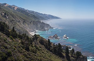
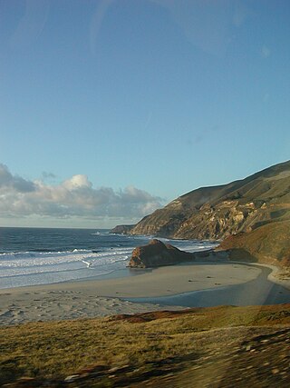
Big Sur is a rugged and mountainous section of the Central Coast of the U.S. state of California, between Carmel Highlands and San Simeon, where the Santa Lucia Mountains rise abruptly from the Pacific Ocean. It is frequently praised for its dramatic scenery. Big Sur has been called the "longest and most scenic stretch of undeveloped coastline in the contiguous United States", a sublime "national treasure that demands extraordinary procedures to protect it from development", and "one of the most beautiful coastlines anywhere in the world, an isolated stretch of road, mythic in reputation". The views, redwood forests, hiking, beaches, and other recreational opportunities have made Big Sur a popular destination for visitors from across the world. With 4.5 to 7 million visitors annually, it is among the top tourist destinations in the United States, comparable to Yosemite National Park, but with considerably fewer services, and less parking, roads, and related infrastructure.
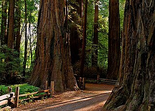
Henry Cowell Redwoods State Park is a state park of California, United States, preserving mainly forest and riparian areas in the watershed of the San Lorenzo River, including a grove of old-growth coast redwood. It is located in Santa Cruz County, primarily in the area between the cities of Santa Cruz and Scotts Valley, near the community of Felton and the University of California at Santa Cruz. The park includes a non-contiguous extension in the Fall Creek area north of Felton. The 4,623-acre (1,871 ha) park was established in 1953.

Kalaloch is an unincorporated resort area entirely within Olympic National Park in western Jefferson County, Washington, United States. Kalaloch accommodations, which include a lodge, rental cabins, and campgrounds, are on a 50-foot (15 m) bluff overlooking the Pacific Ocean, west of U.S. Route 101 on the Olympic Peninsula, north of the reservation of the Quinault Indian Nation.
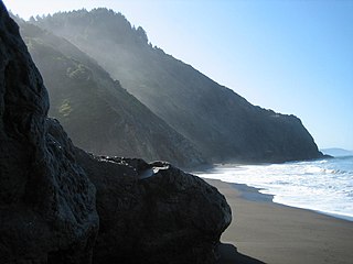
The Lost Coast is a mostly natural and undeveloped area of the California North Coast in Humboldt and Mendocino Counties, which includes the King Range. It was named the "Lost Coast" after the area experienced depopulation in the 1930s. In addition, the steepness and related geotechnical challenges of the coastal mountains made this stretch of coastline too costly for state highway or county road builders to establish routes through the area, leaving it the most undeveloped and remote portion of the California coast. Without any major highways, communities in the Lost Coast region such as Petrolia, Shelter Cove, and Whitethorn are somewhat isolated from the rest of California.
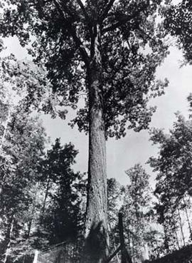
The Mingo Oak was a white oak in the U.S. state of West Virginia. First recognized for its age and size in 1931, the Mingo Oak was the oldest and largest living white oak tree in the world until its death in 1938.
The Little Sur River is a 14.3-mile (23.0 km) long river on the Central Coast of California. The river and its main tributary, the a 11.1-mile (17.9 km) long South Fork, drain a watershed of about 40 square miles (100 km2) of the Big Sur area, a thinly settled region of the Central California coast where the Santa Lucia Mountains rise abruptly from the Pacific Ocean. The South Fork and the North Fork both have their headwaters in the Ventana Wilderness, straddling Mount Pico Blanco. Portions west of the national forest and Old Coast Road lie within the El Sur Ranch. Some portions of the North Fork are on land owned by Granite Rock Company of Watsonville, California, which has owned the mineral rights to 2,800 acres (1,100 ha) on Mount Pico Blanco since 1963. The North and South forks converge about 2 miles (3.2 km) from the coast where the river enters the Pacific Ocean.
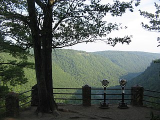
Colton Point State Park is a 368-acre (149 ha) Pennsylvania state park in Tioga County, Pennsylvania, in the United States. It is on the west side of the Pine Creek Gorge, also known as the Grand Canyon of Pennsylvania, which is 800 feet (240 m) deep and nearly 4,000 feet (1,200 m) across at this location. The park extends from the creek in the bottom of the gorge up to the rim and across part of the plateau to the west. Colton Point State Park is known for its views of the Pine Creek Gorge, and offers opportunities for picnicking, hiking, fishing and hunting, whitewater boating, and camping. Colton Point is surrounded by Tioga State Forest and its sister park, Leonard Harrison State Park, on the east rim. The park is on a state forest road in Shippen Township 5 miles (8 km) south of U.S. Route 6.

Mount Hood, also known as Hood Mountain, is a mountain near the southeastern edge of Santa Rosa, California, at the northeast of the Sonoma Valley and attains a height of 2,733 feet (833 m). The original name was Mount Wilikos, an Indian name meaning "willows." Most of the drainage from Mount Hood contributes to the headwaters of Sonoma Creek. A prominent feature is the extensive rock face visible on the upper half of the mountain as viewed from State Route 12. The habitats on the mountain include mixed oak forest, pygmy forest, chaparral and riparian zones. In prehistoric times the slopes of Mount Hood were inhabited by a division of the Yuki tribe. Most of Mount Hood is within the Hood Mountain Regional Park maintained by Sonoma County. Mount Hood is part of the inner coast Mayacamas Range, and lies mostly within Sonoma County, with a part of the mountain geographically within Napa County. Mount Hood affords overlooks of the Pacific Ocean, San Francisco Bay and "a spectacular view east to the Sierra Nevada Range."

Leonard Harrison State Park is a 585-acre (237 ha) Pennsylvania state park in Tioga County, Pennsylvania, in the United States. It is on the east rim of the Pine Creek Gorge, also known as the Grand Canyon of Pennsylvania, which is 800 feet (240 m) deep and nearly 4,000 feet (1,200 m) across here. It also serves as headquarters for the adjoining Colton Point State Park, its sister park on the west rim of the gorge. Leonard Harrison State Park is known for its views of the Pine Creek Gorge, and offers hiking, fishing and hunting, whitewater boating, and camping. The park is in Shippen and Delmar Townships, 10 miles (16 km) west of Wellsboro at the western terminus of Pennsylvania Route 660.

Yosemite West is an unincorporated community and census-designated place (CDP) of resort homes located just outside the southern area of Yosemite National Park, just off Wawona Road, a continuation of State Route 41 from Fresno. It is a census-designated place (CDP), with a population of 47 as of the 2020 census. It is situated one mile (1.6 km) south of the Chinquapin intersection of Wawona Road with Glacier Point Road, at an altitude of 5,100 to 6,300 feet. The elevation reported by the USGS is 5,866 feet (1,788 m). The community is part of Henness Ridge, nearly 3,000 feet (910 m) above the southern banks of the Merced River and State Route 140 from Mariposa. Addresses in this area are shown as "Yosemite National Park, CA 95389".
Eglon is an unincorporated community in Kitsap County, Washington, United States. The town has a community center, a church, a cemetery, a boat launch, a beach, and a picnic area. Its Fire Protection services are provided by North Kitsap Fire and Rescue.
Big Sugar Creek is a 47-mile-long (76 km) waterway in the Ozark Mountains of southwest Missouri. The creek starts near the Arkansas state line. Big Sugar starts from three tributaries. One flows north from Garfield, Arkansas, and one, west near Seligman, Missouri, and another, south from Washburn, Missouri. Big Sugar flows west down Sugar Creek Valley, where in the Jacket community it is joined by Otter Creek, from Pea Ridge, Arkansas.

The Meigs Mountain Trail is an American hiking trail in the Great Smoky Mountains National Park of Sevier County, Tennessee. The trail traverses the northern slopes of Meigs Mountain in the northwest section of the park, connecting Jakes Creek in the Elkmont area with Lumber Ridge in the Tremont area. The Meigs Mountain Trail, when joined with the 4.1-mile (6.6 km) Lumber Ridge Trail and the first 0.4 miles (0.64 km) of the Jakes Creek Trail, is part of a 10.5-mile (16.9 km) continuous path connecting the Appalachian Club section of Elkmont with the Great Smoky Mountains Institute at Tremont. In the early 20th century, the logging communities that formed at Elkmont and Tremont branched out across the relatively broad northern slopes of Meigs Mountain. Other than a crude mountain cemetery, the occasional detritus, and a few rock walls, however, very little remains of the mountain's former inhabitants.

Crow's Nest Natural Area Preserve is a large wilderness area located on the southern border of Stafford County, Virginia, United States, between Potomac Creek and Accokeek Creek. The greater portion of the Crow's Nest Peninsula is approximately 3,800 acres (15 km2) and lies within the coastal plain of Virginia. About 3,115 acres (12.61 km2) of the peninsula is protected as part of the Virginia Natural Area Preserve System. Funding for the original two tracts came from a number of sources including DCR, Stafford County, Virginia Department of environmental Quality and a number other sources.

Venado is an unincorporated community in Sonoma County, California, United States, and is located about 12 miles west of Healdsburg, along Mill Creek Road, below the north slope of Knoll Ridge, on the south bank of Gray Creek, at an elevation of 1,102 feet. The community had a post office from 1921 to 1941. Venado was devastated by the Walbridge Fire in 2020, part of the larger LNU Lightning Complex fire. The Walbridge Fire destroyed many homes and structures in the area, including the Venado Post Office and Daniels School.

Pine Creek Gorge, sometimes called The Grand Canyon of Pennsylvania, is a 47-mile (76 km) gorge carved into the Allegheny Plateau by Pine Creek in north-central Pennsylvania.

Gooseberry River is a 23-mile stream in Lake County, Minnesota, USA, draining into Lake Superior. It is known for its waterfalls, near its mouth in Gooseberry Falls State Park. The Gooseberry, like many of its neighboring streams, has an irregular discharge highly dependent on runoff from rain and snow melt. The region around the river was heavily forested and much logging took place during the early 20th century. The forest has since regrown and the falls and mouth of the river are now a thriving tourist destination.

The Hume-Bennett Lumber Company was a logging operation in the Sequoia National Forest in the late 19th and early 20th centuries. The company and its predecessors were known for building the world's longest log flume and the first multiple-arch hydroelectric dam. However, the company also engaged in destructive clearcutting logging practices, cutting down 8,000 giant sequoias in Converse Basin in a decade-long event that has been described as "the greatest orgy of destructive lumbering in the history of the world."
Horse Heaven is a wildland in the George Washington and Jefferson National Forests of western Virginia, United States, that has been recognized by the Wilderness Society as a special place worthy of protection from logging and road construction. The Wilderness Society has designated the area as a "Mountain Treasure".

The Madera Sugar Pine Company was a United States lumber company that operated in the Sierra Nevada region of California during the late 19th and early 20th centuries. The company distinguished itself through the use of innovative technologies, including the southern Sierra's first log flume and logging railroad, along with the early adoption of the Steam Donkey engine. Its significant regional impact led to the establishment of towns such as Madera, Fish Camp, and Sugar Pine, as well as the growth of Fresno Flats and the formation of Madera County.


