
Cowlitz County is a county located in the U.S. state of Washington. As of the 2020 census, its population was 110,730. The county seat is Kelso, and its largest city is Longview. The county was formed in April 1854. Its name derives from the anglicized version of the Cowlitz Indian term Cow-e-liske, meaning either 'river of shifting sands' or 'capturing the medicine spirit.' Cowlitz comprises the Longview, WA Metropolitan statistical area, which is also included in the Portland-Vancouver-Salem, OR-WA Combined statistical area.

Castle Rock is a city in Cowlitz County, Washington, United States. Located between the Willapa Hills and the western base of Mount St. Helens, Castle Rock is at the heart of Washington timber country in the Pacific temperate rain forest. Castle Rock is part of the Longview, Washington Metropolitan Statistical Area; the population was 2,446 as of the 2020 census.

Kalama (ka-LAM-ma) is a city in Cowlitz County, Washington, United States. It is part of the Longview, Washington Metropolitan Statistical Area. The population was 2,959 as of the 2020 census.

Kelso is a city in the southwestern part of the U.S. state of Washington and is the county seat of Cowlitz County. At the 2020 census, the population was 12,720. Kelso is part of the Longview, Washington Metropolitan statistical area, which has a population of 110,730. Kelso shares its long western border with Longview. It is near Mount St. Helens.

Longview is a city in Cowlitz County, Washington, United States. It is the principal city of the Longview, Washington Metropolitan Statistical Area, which encompasses all of Cowlitz County. Longview's population was 37,818 at the time of the 2020 census, making it the most populous city in Cowlitz County. The city is located in southwestern Washington, at the junction of the Cowlitz and Columbia rivers. Longview shares a border with Kelso to the east, which is the county seat.

The Cowlitz River is a river in the state of Washington in the United States, a tributary of the Columbia River. Its tributaries drain a large region including the slopes of Mount Rainier, Mount Adams, and Mount St. Helens.
Randle is a small town in eastern Lewis County, Washington, United States. Randle is located on U.S. Route 12 and is notable as the northeastern access point to the Mount St. Helens Windy Ridge viewpoint, by way of forest service roads that cut through the Gifford Pinchot National Forest.
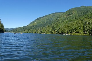
Silver Lake, sometimes Silverlake, is an unincorporated community in Cowlitz County, Washington, in the southwestern portion of the state. Silver Lake is located 6 miles (9.7 km) east of Castle Rock along Washington State Route 504, which is also known as the Spirit Lake Memorial Highway. The area considered Silverlake is about 6 miles (10 km) east of Interstate 5 (I-5) and is approximately 50 miles (80 km) from Portland, Oregon, to the south and Seattle about 110 miles (180 km) to the north. The closest cities to the subject property are Castle Rock, six miles (10 km) to the west, and Toutle, four miles (6 km) east.

Lower Columbia College (LCC) is a public community college in Longview, Washington. LCC offers associate degree programs along with some bachelor degree programs and certification courses. In the 2023-2024 year, LCC awarded 66 certificates, 491 associate degrees, and 5 Bachelor in Applied Science (BAS) degrees.
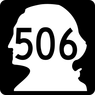
State Route 506 (SR 506) is an 11.53-mile (18.56 km) long state highway in Cowlitz and Lewis counties, part of the U.S. state of Washington, serving the communities of Ryderwood and Vader. SR 506 begins at the intersection of 2nd and Morse Street in Ryderwood, a community in Cowlitz County, traveling north into Lewis County and turning east past Vader to parallel the Cowlitz River and interchange Interstate 5 (I-5) twice west of Toledo. Originating as Secondary State Highway 1P (SSH 1P) in 1937, the highway was designated in its current form in 1964 and it shared its eastern terminus with SR 505. SR 411 terminated at Vader and both SR 411 and SR 505 were moved away from SR 506 in 1991.

State Route 411 (SR 411) is a 13.48-mile (21.69 km) state highway located in Cowlitz County in the U.S. state of Washington, serving Longview, Kelso, West Side Highway and Castle Rock. The roadway, which parallels the Cowlitz River and Interstate 5 (I-5), begins at an interchange with SR 432 in Longview and travels north past a spur route, under SR 4 and across the Cowlitz River to become concurrent with I-5 Business and end at an interchange with I-5, I-5 Business and SR 504 in Castle Rock. The road first appeared on a map in 1951 and originally signed as Secondary State Highway 12H (SSH 12H) in 1957, SR 411 was established in 1964 and ran from Kelso to Vader. In 1991, the highway was extended south to SR 432 in Longview, the former route becoming SR 411 Spur, and was shortened to I-5 / I-5 Business / SR 504 in Castle Rock.
Toutle is an unincorporated community in Cowlitz County, Washington.
Pleasant Hill is an unincorporated community in Cowlitz County, Washington, south of the city of Castle Rock. Pleasant Hill is located along or near Pleasant Hill Road between Castle Rock and Ostrander. The northern end of Pleasant Hill community is part of the Castle Rock School District, while the southern end is part of the Kelso School District.
Kid Valley is an unincorporated community in Cowlitz County, Washington. Kid Valley is located east of the city of Castle Rock and along the North Fork Toutle River. Kid Valley is reached by traveling 17.8 miles (28.6 km) east of Castle Rock along Washington State Route 504, which is also known as the Spirit Lake Memorial Highway. The Kid Valley community is part of the Toutle Lake School District, a K-12 school district of about 600 students.
Sightly is an unincorporated community in Cowlitz County, Washington. Sightly is located east of the city of Castle Rock and east of Silver Lake. Sightly is reached by taking exit 49 off of Interstate 5, traveling 10.4 miles (16.7 km) east along Washington State Route 504, which is also known as the Spirit Lake Memorial Highway, and then traveling 2.4 miles (3.9 km) along Sightly Road. The Sightly community was given its name due to its views of Mount St. Helens. The Sightly community is part of the Toutle Lake School District, a K-12 school district of about 600 students.
Olequa, also known as Olequah, is an unincorporated community in Cowlitz County, Washington. Olequa is located north of the city of Castle Rock on the west bank of the Cowlitz River. Olequa is accessed by traveling 7.5 miles (12.1 km) north on West Side Highway from Castle Rock. The Olequa community is part of the Castle Rock School District, a K-12 school district of about 1,300 students.

Swofford, also known as Swofford Valley, is an unincorporated community in central Lewis County, in the U.S. state of Washington. The town sits on the south shore of Riffe Lake, approximately 4.0 miles (6.4 km) southeast of Mossyrock.

Chester was a shallow draft steamboat built in 1897 that ran until 1917, mostly on the Cowlitz River in southwestern Washington.
Beacon Hill is an unincorporated community and census-designated place (CDP) in Cowlitz County, Washington, United States. As of the 2020 census, it had a population of 2,211. During the 2010 census, Beacon Hill was part of the West Side Highway CDP.
Lexington is an unincorporated community and census-designated place (CDP) in Cowlitz County, Washington, United States. As of the 2020 census, it had a population of 3,834. During the 2010 census, Lexington was part of the West Side Highway CDP.


