
Kelso is a city in the southwestern part of the U.S. state of Washington and is the county seat of Cowlitz County. At the 2020 census, the population was 12,720. Kelso is part of the Longview, Washington Metropolitan statistical area, which has a population of 110,730. Kelso shares its long western border with Longview. It is near Mount St. Helens.

Woodland is a city in Clark and Cowlitz counties in Washington, United States. Most residents live within Cowlitz County, in which the majority of the city lies. It is part of the Longview, Washington Metropolitan Statistical Area. The population was 6,531 at the 2020 census.

The Cowlitz River is a river in the state of Washington in the United States, a tributary of the Columbia River. Its tributaries drain a large region including the slopes of Mount Rainier, Mount Adams, and Mount St. Helens.

Kelso is a ghost town and defunct railroad depot in the Mojave National Preserve in San Bernardino County, California, USA. It was named after railroad worker John H. Kelso, whose name was placed into a hat along with two other workers to decide the name of the town. The town was built in 1905 specifically as a railroad station along the rail line between Utah and Los Angeles, originally called "Siding 16," because of its location and nearby springs that provided abundant water. Historic Spots in California states, "At Kelso stands a beautiful Spanish-style Union Pacific Depot built about 1906, surrounded by shade trees, a welcome rarity in the hot, barren desert."
Carrolls is an unincorporated community in Cowlitz County, Washington, south of the city of Kelso. Carrolls is located south on Old Pacific Highway from exit 36 of Interstate 5. The Carrolls community is part of the Kelso School District, a K-12 school district of nearly 5,000 students.
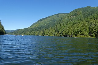
Silver Lake, sometimes Silverlake, is an unincorporated community in Cowlitz County, Washington, in the southwestern portion of the state. Silver Lake is located 6 miles (9.7 km) east of Castle Rock along Washington State Route 504, which is also known as the Spirit Lake Memorial Highway. The area considered Silverlake is about 6 miles (10 km) east of Interstate 5 (I-5) and is approximately 50 miles (80 km) from Portland, Oregon, to the south and Seattle about 110 miles (180 km) to the north. The closest cities to the subject property are Castle Rock, six miles (10 km) to the west, and Toutle, four miles (6 km) east.

West Union is an unincorporated community in Washington County, Oregon, United States. Founded in 1851, the community had the first school district in the county; it also contains the oldest cemetery in the state and the oldest Baptist church west of the Rocky Mountains. It is located north of Hillsboro near the intersection of West Union Road and Cornelius Pass Road north of the Sunset Highway. The name comes from a grove of five oak trees that was used as a meeting place of early settlers, or the "union of the west." West Union had a post office from 1874 to 1894.
Etna is an unincorporated community in Bloomfield Township, Fillmore County, Minnesota, United States. Etna is located within ZIP code 55975 based in Spring Valley.

Glencoe is a neighborhood and former community in Washington County, Oregon, United States. Founded in 1842, the town, which was north of Hillsboro, died off after 1910 when neighboring North Plains was created to the west. Most of Glencoe is now a part of North Plains. Glencoe gives its name to the road connecting Hillsboro to North Plains, as well as the name of the second high school built in Hillsboro, Glencoe High School.
Claraville is an unincorporated community in Kern County, California. It is located 13 miles (21 km) north of Emerald Mountain, at an elevation of 6,302 feet (1,921 m).

Mountaindale is an unincorporated community in Washington County, Oregon, United States, about four miles northwest of North Plains. Settled in the 1850s, the small community was the longtime home of the Mountaindale Store. The area is part of Washington County Fire District 2.
Kelso is an unincorporated community located about three miles northwest of Sandy in Clackamas County, Oregon, United States. It was named for the town of Kelso, Washington. The post office operated for ten years, from May 31, 1894 to May 26, 1904.

Marshall is an unincorporated community in Spokane County, Washington, United States. Named in 1880 for early settler William H. Marshall, Marshall has a post office with ZIP code 99020.

Campbellville is a compact rural community in the geographic township of Nassagaweya in the Town of Milton, Ontario. It is on the Niagara Escarpment and is a tourist destination for residents of the Greater Toronto Area.
Southcrest is a community in southeastern Houston, Texas. It is bordered by the 610 Loop, Martin Luther King Boulevard, Bellfort Boulevard, and Mykawa Road.
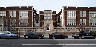
Bruce-Monroe Elementary School at Park View is a bilingual elementary school in Washington, D.C. Named after Blanche Bruce and James Monroe, it has been located in the historic Park View School in the city's Park View neighborhood since 2008. It is part of the District of Columbia Public Schools.
Rose Valley is an unincorporated community in Cowlitz County, Washington, southeast of the city of Kelso. Rose Valley is located south on Old Pacific Highway from exit 36 of Interstate 5, then east on Rose Valley Road. The Rose Valley community is part of the Kelso School District, a K-12 school district of nearly 5,000 students.
Pleasant Hill is an unincorporated community in Cowlitz County, Washington, south of the city of Castle Rock. Pleasant Hill is located along or near Pleasant Hill Road between Castle Rock and Ostrander. The northern end of Pleasant Hill community is part of the Castle Rock School District, while the southern end is part of the Kelso School District.
Olequa, also known as Olequah, is an unincorporated community in Cowlitz County, Washington. Olequa is located north of the city of Castle Rock on the west bank of the Cowlitz River. Olequa is accessed by traveling 7.5 miles (12.1 km) north on West Side Highway from Castle Rock. The Olequa community is part of the Castle Rock School District, a K-12 school district of about 1,300 students.
Concord is an unincorporated community and former post office in southeastern Hampshire County in the U.S. state of West Virginia. It is located along Eldridge Road between the unincorporated communities of Lehew and Yellow Spring.


