
Cowlitz County is a county located in the U.S. state of Washington. As of the 2010 census, its population was 102,410. The county seat is Kelso, and its largest city is Longview. The county was formed in April 1854. Its name derives from the anglicized version of the Cowlitz Indian term Cow-e-liske, meaning either 'river of shifting sands' or 'capturing the medicine spirit.'

Castle Rock is a city in Cowlitz County, Washington, United States. Located between the Willapa Hills and the western base of Mount St. Helens, Castle Rock is at the heart of Washington timber country in the Pacific temperate rain forest. Castle Rock is part of the Longview, Washington Metropolitan Statistical Area; the population was 1,982 as of the 2010 census.

Kelso is a city in the southwestern part of the U.S. state of Washington and is the county seat of Cowlitz County. At the 2010 census, the population was 11,925. Kelso is part of the Longview, Washington Metropolitan Statistical Area, which has a population of 102,410. Kelso shares its long western border with Longview. It is near Mount St. Helens.

Woodland is a city in Clark and Cowlitz counties in the State of Washington. Most residents live within Cowlitz County, in which the majority of the city lies. It is part of the 'Longview, Washington Metropolitan Statistical Area'. The population was 5,509 at the 2010 census.

The Cowlitz River is a river in the state of Washington in the United States, a tributary of the Columbia River. Its tributaries drain a large region including the slopes of Mount Rainier, Mount Adams, and Mount St. Helens.

Carrolls is an unincorporated community in Cowlitz County, Washington, south of the city of Kelso. Carrolls is located south on Old Pacific Highway from exit 36 of Interstate 5. The Carrolls community is part of the Kelso School District, a K-12 school district of nearly 5,000 students.
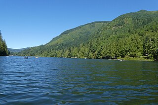
Silver Lake, sometimes Silverlake, is an unincorporated community in Cowlitz County, Washington, in the southwestern portion of the state. Silver Lake is located 6 miles (9.7 km) east of Castle Rock along Washington State Route 504, which is also known as the Spirit Lake Memorial Highway. The area considered Silverlake is about 6 miles (10 km) east of Interstate 5 (I-5) and is approximately 50 miles (80 km) from Portland, Oregon, to the south and Seattle about 110 miles (180 km) to the north. The closest cities to the subject property are Castle Rock, six miles (10 km) to the west, and Toutle, four miles (6 km) east.
Toutle is an unincorporated community in Cowlitz County, Washington.
The Aldercrest-Banyon landslide was a major slow-moving landslide in the east Kelso, Washington neighborhood of Aldercrest beginning in early 1998 through 1999. The disaster ended up being one of the worst urban landslides in United States history in terms of cost. The landslide is one of the most notable in Washington state, which has many landslides due to its mountainous terrain. The Aldercrest-Banyon landslide was the first landslide disaster in the United States that the Federal Emergency Management Agency (FEMA) declared an official disaster area.
Ostrander is an unincorporated community in Cowlitz County, Washington, north of the city of Kelso. Ostrander is located north on North Pacific Avenue from exit 42 of Interstate 5. The Ostrander community is part of the Kelso School District, a K-12 school district of nearly 5,000 students.
Rose Valley is an unincorporated community in Cowlitz County, Washington, southeast of the city of Kelso. Rose Valley is located south on Old Pacific Highway from exit 36 of Interstate 5, then east on Rose Valley Road. The Rose Valley community is part of the Kelso School District, a K-12 school district of nearly 5,000 students.
Vision Acres is an unincorporated community in Cowlitz County, Washington, south of the city of Kelso. Vision Acres is located south on Old Pacific Highway from exit 36 of Interstate 5. The Vision Acres community is part of the Kelso School District, a K-12 school district of nearly 5,000 students.
Pleasant Hill is an unincorporated community in Cowlitz County, Washington, south of the city of Castle Rock. Pleasant Hill is located along or near Pleasant Hill Road between Castle Rock and Ostrander. The northern end of Pleasant Hill community is part of the Castle Rock School District, while the southern end is part of the Kelso School District.
Davis Terrace is an unincorporated community in Cowlitz County, Washington, nearly surrounded by the city of Kelso. Davis Terrace is located south bank of the Coweeman River near the intersection of Grade Street and Coweeman Drive. The Davis Terrace community is part of the Kelso School District, a K-12 school district of nearly 5,000 students.
Rocky Point is an unincorporated community in Cowlitz County, Washington, north of the city of Kelso. Rocky Point is located directly north of Kelso along or near North Pacific Avenue. The Rocky Point community is part of the Kelso School District, a K-12 school district of nearly 5,000 students.
Headquarters is an unincorporated community in Cowlitz County, Washington, southeast of the city of Castle Rock. The Headquarters community is split between the Castle Rock School District, the Kelso School District and the Toutle Lake School District.
Saint Helens is an unincorporated community in Cowlitz County, Washington. Saint Helens is located east of the city of Castle Rock and along the North Fork Toutle River. Saint Helens is reached by traveling 24 miles (39 km) east of Castle Rock along Washington State Route 504, which is also known as the Spirit Lake Memorial Highway. The Saint Helens community takes its name from Mount St. Helens, which, in turn, was named by explorer George Vancouver after a friend of his, Baron St. Helens. The Saint Helens community is part of the Toutle Lake School District, a K-12 school district of about 600 students.
Kid Valley is an unincorporated community in Cowlitz County, Washington. Kid Valley is located east of the city of Castle Rock and along the North Fork Toutle River. Kid Valley is reached by traveling 17.8 miles (28.6 km) east of Castle Rock along Washington State Route 504, which is also known as the Spirit Lake Memorial Highway. The Kid Valley community is part of the Toutle Lake School District, a K-12 school district of about 600 students.
Sightly is an unincorporated community in Cowlitz County, Washington. Sightly is located east of the city of Castle Rock and east of Silver Lake. Sightly is reached by taking exit 49 off of Interstate 5, traveling 10.4 miles (16.7 km) east along Washington State Route 504, which is also known as the Spirit Lake Memorial Highway, and then traveling 2.4 miles (3.9 km) along Sightly Road. The Sightly community was given its name due to its views of Mount St. Helens. The Sightly community is part of the Toutle Lake School District, a K-12 school district of about 600 students.
Olequa, also known as Olequah, is an unincorporated community in Cowlitz County, Washington. Olequa is located north of the city of Castle Rock on the west bank of the Cowlitz River. Olequa is accessed by traveling 7.5 miles (12.1 km) north on West Side Highway from Castle Rock. The Olequa community is part of the Castle Rock School District, a K-12 school district of about 1,300 students.


