
Coldvreath is a hamlet south-southwest of Roche in Cornwall, England. [1] It is in the civil parish of Roche.
Coldvreath is a hamlet south-southwest of Roche in Cornwall, England. [1] It is in the civil parish of Roche.

St Wenn is a civil parish and village in Cornwall, England, United Kingdom. The village is situated six miles (10 km) west of Bodmin and nine miles (14.5 km) east of Newquay. The parish population at the 2011 census was 369.

The River Inny is a small river in east Cornwall, United Kingdom. It is a tributary of the River Tamar and is about twenty miles (32 km) long from its source near Davidstow on the eastern flank of Bodmin Moor to its confluence with the Tamar at Inny Foot near Dunterton.

The River Allen in north Cornwall is one of two rivers in Cornwall which share this name. In this case the name is the result of a mistake made in 1888 by Ordnance Survey, replacing the name Layne with Allen which is the old name for the lower reaches of the Camel. The other River Allen runs through Truro.

The De Lank River is a small river in north Cornwall, England. It is a tributary of the River Camel and is approximately nine miles (14.5 km) long from its source on Bodmin Moor to its confluence with the Camel two miles (3 km) south of St Breward.

Churchbridge is a hamlet in Cornwall, England. It is a mile west of Duloe, and is situated on the West Looe River. Both banks of the river are wooded, and to the north of the bridge is a disused quarry and Tremadart Mills, marked as a corn mill on the 1882 map.

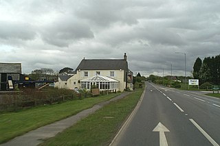
Congdon's Shop is a hamlet in the parish of North Hill, Cornwall, England. It is at the junction of the B3254 Launceston to Liskeard road and the B3257 road from Plusha to Callington.

Connon is a hamlet near Liskeard in Cornwall, England. Connon is in the civil parish of St Pinnock.
Victoria is a hamlet in Cornwall, England, UK. It is located in the civil parish of Roche, 1 mile (1.6 km) north of Roche village and 6 miles (9.7 km) north of the town of St Austell.
Halton Barton is a farm in the parish of St Dominic in Cornwall, England.
Haye Farm is a farm in the parish of Callington, Cornwall, England.

Higher Town is a hamlet northeast of Roche in mid Cornwall, England.

Lanjew is a farm in the parish of Withiel in Cornwall, England.

Mount Pleasant is a hamlet in the parish of Roche, Cornwall, England. The main A30 road used to pass through the hamlet but a dual carriageway bypass and graded junction have been constructed to the south of the original road. There is a Grade II listed eighteenth century guidestone beside the old road, consisting of a 5-foot (1.5 m) granite monolith with a rounded head. The text "WITHIEL" is carved into it, and the letters are painted.
Muchlarnick is a hamlet in Cornwall, England. It is about two miles east of Lanreath in the civil parish of Pelynt.
Penmayne is a hamlet next to Splatt in the civil parish of St Minver Lowlands in north Cornwall, England, UK.
Pennytinney is a hamlet in the parish of St Kew, Cornwall, England, UK.
Penpillick is a hamlet in Cornwall, England, UK. It is about two miles north of St Blazey on the A390 road.

Tregoss is a hamlet in the parish of Roche, Cornwall, England, United Kingdom. To the east is Tregoss Moor.

The River Kensey is a river in east Cornwall, England, UK which is a tributary of the River Tamar.

The River Lerryn is a river in east Cornwall, England, UK, a tributary of the River Fowey. The Lerryn is the largest of the tributaries which enter the estuary of the Fowey. The river is tidal up to the village of Lerryn. The landscape of the Lerryn catchment is rural and includes heathland, moorland and rough pasture in the upper reaches and broadleaf, coniferous and mixed plantation woodland in the lower. This catchment includes four SSSIs, including Redlake Meadows & Hoggs Moor. The Lerryn rises at Fairy Cross on the southern slopes of Bodmin Moor and flows south-southwest until it enters the Fowey estuary.
| Unitary authorities | |
|---|---|
| Major settlements |
|
| Rivers | |
| Topics | |
Coordinates: 50°23′34″N4°49′58″W / 50.3928165°N 4.832654°W
| This article about a location in the former borough of Restormel, Cornwall is a stub. You can help Wikipedia by expanding it. |