A farm is an area of land that is devoted primarily to agricultural processes with the primary objective of producing food and other crops; it is the basic facility in food production. The name is used for specialized units such as arable farms, vegetable farms, fruit farms, dairy, pig and poultry farms, and land used for the production of natural fiber, biofuel, and other commodities. It includes ranches, feedlots, orchards, plantations and estates, smallholdings, and hobby farms, and includes the farmhouse and agricultural buildings as well as the land. In modern times, the term has been extended so as to include such industrial operations as wind farms and fish farms, both of which can operate on land or at sea.

A family farm is generally understood to be a farm owned and/or operated by a family; it is sometimes considered to be an estate passed down by inheritance.

Land reform is a form of agrarian reform involving the changing of laws, regulations, or customs regarding land ownership. Land reform may consist of a government-initiated or government-backed property redistribution, generally of agricultural land. Land reform can, therefore, refer to transfer of ownership from the more powerful to the less powerful, such as from a relatively small number of wealthy or noble owners with extensive land holdings to individual ownership by those who work the land. Such transfers of ownership may be with or without compensation; compensation may vary from token amounts to the full value of the land.
Land reform in Zimbabwe officially began in 1980 with the signing of the Lancaster House Agreement, to reverse the distribution of land that resulted from the colonial occupation of the country by white people. The colonial distribution that started in 1884, took land from black people, land the black people called home and used for habitation and production as subsistence farmers. The colonisers drove black people to dry and unproductive land while they shared prime and productive land amongst themselves resulting in a population of 3% owning 51% of the land while 4.3 million black people owned 42%, with the remainder being land for towns and other non-farming activities. The white people enjoyed superior political and economic status, but this was resisted, leading to war, and political independence in 1980. At independence, the Lancaster House Agreement was signed and it had a clause that prohibitted return of land, except where a white person had surrendered or offered it for sale. This did not return enough land until the accelerated land reform programme started in 2000. The programme altered the racial imbalance of land ownership.
An ejido is an area of communal land used for agriculture in which community members have usufruct rights rather than ownership rights to land, which in Mexico is held by the Mexican state. People awarded ejidos in the modern era farm them individually in parcels and collectively maintain communal holdings with government oversight. Although the system of ejidos was based on an understanding of the preconquest Aztec calpulli and the medieval Spanish ejido, since the 20th century ejidos have been managed and controlled by the government.

Zimbabwe Parks and Wildlife Management Authority (Zimparks) is an agency of the Zimbabwe government managing national parks. Zimbabwe's game reserves are managed by the government. They were initially founded as a means of using unproductive land.
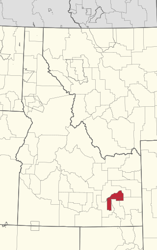
The Fort Hall Reservation is a Native American reservation of the federally recognized Shoshone-Bannock Tribes in the U.S. state of Idaho. This is one of five federally recognized tribes in the state. The reservation is located in southeastern Idaho on the Snake River Plain about 20 miles (32 km) north and west of Pocatello. It comprises 814.874 sq mi (2,110.51 km2) of land area in four counties: Bingham, Power, Bannock, and Caribou. To the east is the 60-mile-long (97 km) Portneuf Range; both Mount Putnam and South Putnam Mountain are located on the Fort Hall Reservation.

A smallholding or smallholder is a small farm operating under a small-scale agriculture model. Definitions vary widely for what constitutes a smallholder or small-scale farm, including factors such as size, food production technique or technology, involvement of family in labor and economic impact. Smallholdings are usually farms supporting a single family with a mixture of cash crops and subsistence farming. As a country becomes more affluent, smallholdings may not be self-sufficient, but may be valued for the rural lifestyle. As the sustainable food and local food movements grow in affluent countries, some of these smallholdings are gaining increased economic viability. There are an estimated 500 million smallholder farms in developing countries of the world alone, supporting almost two billion people.

The Great Sioux Reservation initially set aside land west of the Missouri River in South Dakota and Nebraska for the use of the Sioux, who had dominated this territory. The reservation was established in the Fort Laramie Treaty of 1868. It included all of present-day western South Dakota and modern Boyd County, Nebraska. This area was established by the United States as a reservation for the Teton Sioux, also known as the Lakota: the seven western bands of the "Seven Council Fires".

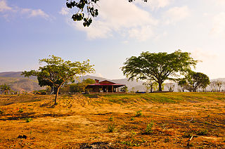
The Arhuaco are an indigenous people of Colombia. They are Chibchan-speaking people and descendants of the Tairona culture, concentrated in northern Colombia in the Sierra Nevada de Santa Marta.
Social forestry is the management and protection of forests and afforestation of barren and deforested lands with the purpose of helping environmental, social and rural development. The term social forestry was first used in 1976 by The National Commission on Agriculture, when the government of India aimed to reduce pressure on forests by planting trees on all unused and fallow lands. It was intended as a democratic approach to forest conservation and usage, maximizing land utilization for multiple purposes.

Mwenezi, originally known as Nuanetsi, is a small district situated in southern Zimbabwe. It is bisected by the Mwenezi River and the A4 highway, the main thoroughfare that connects the town of Beitbridge, on the border with South Africa, to Masvingo.
Land is owned in Canada by governments, Indigenous groups, corporations, and individuals. Canada is the second-largest country in the world by area; at 9,093,507 km2 or 3,511,085 mi2 of land. It occupies more than 6% of the Earth's surface.

Land reform is an important political and economic topic in Namibia. It consists of two different strategies: resettlement, and transfer of commercially viable agricultural land. Resettlement is aimed at improving the lives of displaced or dispossessed previously disadvantaged Namibians. Farms obtained by government for resettlement purposes are usually split into several sections, and dozens of families are being resettled on what had previously been one farm. Transfer of commercial agricultural land is not directly conducted by government. Would-be farmers with a previously disadvantaged background obtain farms privately or through affirmative action loans. In both cases, the "Willing buyer, willing seller" principle applies.

Land grabbing is the large-scale acquisition of land through buying or leasing of large pieces of land by domestic and transnational companies, governments, and individuals.
Chitomborwizi is a farming area in Mashonaland West in Zimbabwe formerly known as Chitomborwizi African Purchase Area. The farms are small to medium sizes. Areas like these were created for black farmers during the colonial era, similar areas are Musengezi near Chegutu, Mushagashe near Chatsworth, Zimbabwe, Wilshere in Chivhu, Matepatepa in Mt Darwin to mention just a few.
Agrarian reform and land reform have been a recurring theme of enormous consequence in world history. They are often highly political and have been achieved in many countries.

Collective farming and communal farming are various types of "agricultural production in which multiple farmers run their holdings as a joint enterprise". There are two broad types of communal farms: agricultural cooperatives, in which member-owners jointly engage in farming activities as a collective; and state farms, which are owned and directly run by a centralized government. The process by which farmland is aggregated is called collectivization. In some countries, there have been both state-run and cooperative-run variants. For example, the Soviet Union had both kolkhozy and sovkhozy.
Land reform in South Africa is the promise of "land restitution" to empower farm workers and reduce inequality. This also refers to aspects such as, property, possibly white-owned businesses. Proponents argue it will allow previously unemployed people to participate in the economy and better the country's economic growth. It also relates to restitution in the form of settling Land Claims of people who were forcefully removed from their homes in urban areas that were declared white, by the apartheid government's segregationist Group Areas Act: such areas include Sophiatown, Fietas, Cato Manor, District Six and Greyville; as well as restitution for people forcibly evicted from rural land because of apartheid policies.

Umzingwane is a district in the northern part of Matabeleland South province in Zimbabwe. It was formerly known as Esigodini and before 1982 as Essexvale.