Praze an Beeble, sometimes shortened to Praze, is a village in Cornwall, Great Britain. It lies between the nearby towns of Camborne and Helston in the civil parish of Crowan.

Godrevy is an area on the eastern side of St Ives Bay, west Cornwall, England, United Kingdom, which faces the Atlantic Ocean. It is popular with both the surfing community and walkers. It is part owned by the National Trust, and offshore on Godrevy Island is a lighthouse maintained by Trinity House which is said to be the inspiration for Virginia Woolf's novel To the Lighthouse. Godrevy lies within the Cornwall Area of Outstanding Natural Beauty (AONB) and the South West Coast Path runs around the whole promontory. There are several public car parks on the western side where the National Trust owns and operates a café.

Hayle is a port town and civil parish in west Cornwall, England, United Kingdom. It is situated at the mouth of the Hayle River and is approximately seven miles (11 km) northeast of Penzance.

Gwithian is a coastal village and former civil parish, now in the parish of Gwinear-Gwithian, in the Cornwall district, in west Cornwall, England. It is three miles (5 km) north-east of Hayle and four miles (6.5 km) east of St Ives, Cornwall across St Ives Bay. In 1931 the parish had a population of 634. On 1 April 1934 the parish was abolished to form "Gwinear Gwithian".

Coverack is a coastal village and fishing port in Cornwall, UK. It lies in the parish of St Keverne, on the east side of the Lizard peninsula about nine miles (14 km) south of Falmouth.

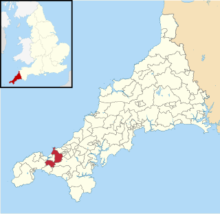
Gwinear–Gwithian is a coastal civil parish in west Cornwall, England, United Kingdom. It includes the villages of Connor Downs, Gwinear, Gwithian, Reawla and Rosewarne. The parish is situated approximately two miles (3 km) east of Hayle two miles (3 km) west of Camborne.

Angarrack is a village in west Cornwall, England, UK. It is in the parish of Gwinear-Gwithian a mile to the east of Hayle. Immediately south of the village Angarrack viaduct carries the Cornish mainline railway over the Angarrack River. The name comes from An Garrek which means "The Rock" in the Cornish language. According to the Ordnance Survey the spelling is Angarrack but on signs near the village, it is variously spelled Angarrack, Angharrack, or Angarrick.

Whitstone is a village and civil parish in east Cornwall, England, United Kingdom. It is roughly halfway between the towns of Bude and Launceston. The population at the 2011 census was 590.

Penwith Hundred was one of ten ancient administrative hundreds of the county of Cornwall, England, UK. The ancient hundred of Penwith was larger than the local government district of Penwith (1974–2009) which took its name. Daphne du Maurier in Vanishing Cornwall suggests that the name, Penwith, has three renderings, "the last promontory," "promontory on the left, and "the headland of slaughter," thus suggesting that this area might have been the site of prehistoric invasions of sea-borne fighters, or perhaps tribal battles. The eastern part became part of Kerrier District.

Towan is found in many placenames in Cornwall. However, The Towans usually refers to the three-mile (5 km) stretch of coastal dunes which extends north-east from the estuary of the River Hayle to Gwithian beach with a midpoint near Upton. The South West Coast Path crosses the towans.

Shortlanesend is a village in Kenwyn parish, Cornwall, England, United Kingdom. It lies two miles north of the city of Truro at grid reference SW 805 475. The name was recorded as Penfounder in 1547. Shortlanesend is in the former Carrick District. The village has a pub, the Old Plough Inn, a post office and school.
St Ives Bay is a bay on the Atlantic coast of north-west Cornwall, England, United Kingdom. It is in the form of a shallow crescent, some 4 miles or 6 km across, between St Ives in the west and Godrevy Head in the east.
Otterham is a village and a civil parish in north Cornwall, England, United Kingdom. The village is situated approximately ten miles (16 km) south of Bude and six miles (9.7 km) north of Camelford.

Reawla is a hamlet in Penwith district in Cornwall. It is in the civil parish of Gwinear-Gwithian.
Gwinear is a small village and former civil parish, now in the parish of Gwinear-Gwithian, in the Cornwall district, in west Cornwall, England, UK. It is about two miles (3 km) east of Hayle and overlooks the Angarrack valley. In 1931 the parish had a population of 1234. On 1 April 1934 the parish was abolished to form "Gwinear Gwithian".

Roseworthy is a hamlet on the A30 trunk road in the parish of Gwinear-Gwithian in Cornwall, England, UK.
Gwinear-Gwithian and St Erth was an electoral division of Cornwall in the United Kingdom which returned one member to sit on Cornwall Council between 2009 and 2021. It was abolished at the 2021 local elections, being succeeded by Gwinear-Gwithian and Hayle East and Long Rock, Marazion and St Erth.

Gwinear-Gwithian and Hayle East is an electoral division of Cornwall in the United Kingdom which returns one member to sit on Cornwall Council. It was created at the 2021 local elections, being created from the former divisions of Gwinear-Gwithian and St Erth, Hayle North, and Hayle South. The current councillor is Lionel Pascoe, a Conservative.

