Convention Place station

Last updated

Convention Place
Transit tunnel station
Convention Place from Boren Avenue, 2016 - 01.jpg
Westward view from Boren Avenue at the platforms and plaza level, two years prior to closure
General information
LocationPine Street & 9th Avenue
Seattle, Washington, U.S.
Coordinates 47°36′50″N122°19′55″W / 47.61389°N 122.33194°W / 47.61389; -122.33194
Owned by King County Metro
Bus routes7
Bus stands5
Bus operators King County Metro, Sound Transit Express
Connections Community Transit, King County Metro, Sound Transit Express
Construction
Structure typeSurface
ParkingPay parking nearby
Bicycle facilities Bicycle rack
AccessibleYes
History
OpenedSeptember 15, 1990 (1990-09-15)
ClosedJuly 21, 2018 (2018-07-21)

Convention Place was a bus station in Seattle, Washington, United States. It served as the northern terminus of the Downtown Seattle Transit Tunnel and was used by King County Metro and Sound Transit Express buses. Link light rail, which stops at the tunnel's other four stations, did not serve Convention Place. From the station, buses continued onto the Interstate 5 reversible express lanes or Olive Way via two exits. The station's platforms were accessed via a plaza located at the intersection of Pine Street and 9th Avenue near the Washington State Convention Center and Paramount Theatre.

Contents

The station began construction in 1987 and opened on September 15, 1990. During planning of the Link light rail system in the 1990s, Convention Place was identified as a potential light rail stop or terminus, but was cut in favor of a deeper crossing of Interstate 5 towards Capitol Hill. The station was offered by Metro as a site for transit-oriented development and attracted interest from the convention center for a potential expansion. After a stalled attempt in 2009, the expansion was launched in the early 2010s and Convention Place station was sold for $162 million.

Convention Place station was permanently closed on July 21, 2018, a few months before bus service in the transit tunnel ended. After demolition, the Seattle Convention Center Summit building was constructed on the site and opened in 2023.

History

A dual-mode bus at Convention Place station, seen in 2000. The Paramount Theatre overlooked the station and its retaining wall on Pine Street. Breda 5234 at south platform of Convention Place station in 2000.jpg
A dual-mode bus at Convention Place station, seen in 2000. The Paramount Theatre overlooked the station and its retaining wall on Pine Street.

The Metro Transit Committee selected the intersection of Pine Street and Interstate 5 as the preferred northern terminus for the proposed downtown transit system — either a bus tunnel or surface transit mall — in 1979. [1] The busway alternative would have placed a major terminal at either Westlake Park or a two-block section of Pine Street on the west side of Interstate 5. [2] The bus tunnel was chosen by Metro in November 1983, [3] including a northern portal at Pine Street and 9th Avenue. [4] [5] By early 1984, a site on Pike Street one block south of the planned tunnel portal was chosen for the city's planned convention center, which would open by the end of the decade. [6] [7]

Construction of the northern portal station, later named Convention Place, [8] began after the acquisition of a 16-unit low-income apartment building, a medical center, and several small businesses. [7] [9] SCI Contractors of Calgary was awarded the $74.5 million contract for the Pine Street segment, including Convention Place and Westlake stations, in February 1987. [8] The Pine Street ramp to the Interstate 5 express lanes was closed in April, along with a segment of Pine Street between 3rd and Boren avenues. [10] Excavation of the Pine Street tunnel was complete by the end of the year and temporarily backfilled during the Christmas shopping season for use of Pine Street by automobile traffic. [11] Excavation of the Convention Place station continued into the following year; [12] by the end of 1988, construction of the exit ramp to Olive Way and the electrical substation had been completed. [13] The bus tunnel was completed in early 1990, [14] and Convention Place station was dedicated during an opening celebration on September 14, 1990. [15] Bus service in the tunnel began the following day, with the inaugural run traveling southbound from Convention Place station. [16] [17] At Convention Place and the tunnel's other terminus, International District, the dual-mode buses used in the tunnel would switch from diesel fuel to electric overhead wires, functioning as trolleybuses within the tunnel. [18] The dual-mode fleet was replaced in 2004 with hybrid buses, which switch from diesel to their electric batteries at the termini. [19] [20]

Light rail plans and renovation

Overhead view of Convention Place station and its bus staging area, including several unused light rail tracks Conventionplacestation3.JPG
Overhead view of Convention Place station and its bus staging area, including several unused light rail tracks

The bus tunnel was designed to accommodate light rail trains, including pre-installed rails that were later found unusable due to their inadequate insulation. [21] In early light rail plans, Convention Place was listed as the northernmost downtown station before trains continued towards First Hill or Eastlake. [22] [23] Voters in the Seattle metropolitan area approved the Sound Move package in 1996, funding a light rail system to be built by Sound Transit. [24] A 1998 report from Sound Transit stated that a light rail line continuing north from downtown would be unable to use Convention Place due to its shallow height and recommended its abandonment. Metro and several members of the Sound Transit Board requested that the station be kept and modified in order to serve the expanded convention center, delaying a decision for several months. [25] In their preferred alternative for the Central Link light rail project, published in 1999, Sound Transit selected a tunnel route that avoids Convention Place. [26] Sound Transit took ownership of the four southern bus tunnel stations in 2000, while King County Metro retained Convention Place for potential redevelopment into office or hotel use. [27]

Sound Transit began re-evaluating the light rail project in 2001 due to a funding shortfall and the discovery of soil issues along the route of the planned tunnel to the University District. [28] [29] The light rail line was shortened to the segment between Downtown Seattle and Seattle–Tacoma International Airport, leaving the remainder to Capitol Hill, the University District, and Northgate for a future expansion. [30] The Sound Transit Board chose Convention Place as the northern terminus of the line in September 2001, [31] but was replaced by a Westlake terminus in the Record of Decision issued by the Federal Transit Administration in May 2002. [32] Further study of Convention Place as a light rail station on the northern extension was discontinued by Sound Transit later that month after the agency's study concluded that it would have no effect on ridership and lead to greater engineering difficulties. [33] [34] For the extension's Eastlake alternatives, a new rail-only station would have been built 40 to 60 feet (12 to 18 m) below street level. [35]

The bus tunnel was closed on September 23, 2005, for a two-year renovation of the four stations set to receive light rail service. [36] The ramps from the Interstate 5 express lanes to Convention Place remained open during construction, allowing buses to continue onto 9th Avenue towards Stewart Street. [37] [38] A short tunnel under Pine Street on the south side of the station was also built as a future turnback area for trains and as part of the extension to Capitol Hill. [39] The tunnel was reopened on September 24, 2007, [40] with the other stations receiving major refurbishment and Convention Place retaining its original equipment. [41]

Closure and redevelopment

Demolition of the platforms, as seen in late July 2018 Convention Place Station demolition, viewed from Boren Ave.jpg
Demolition of the platforms, as seen in late July 2018

Convention Place station had been envisioned by Metro as a site for high-rise development since the transit tunnel was designed in the 1980s. [42] [43] The eventual abandonment of the station after buses are phased out of the transit tunnel spurred Metro to offer the land to developers for $32 million in 2000, [27] and eventually air rights that allow for continued transit use. [44] A feasibility and market study was planned to be published in 2001, [45] but was later put on hold. [46]

In 2008, the Washington State Convention and Trade Center Board proposed a $766 million addition to the convention center on the site of Convention Place station, doubling the amount of exhibition space. [47] The expansion, which would have been completed in 2014, [48] was put on hold after the state legislature turned down a tax increase to support the project. [49] The convention center revived its expansion plans in 2012, conducting a feasibility study and acquiring nearby properties along Olive Way; [50] [51] in early plans, the convention center offered to build a mixed-use complex atop the station in addition to exhibition space. [52] Negotiations between the convention center and transit agencies began in 2014 and ended with a preliminary agreement in November 2015 to sell the station. [53] Under the preliminary agreement, Metro would sell the station for $147 million, to be paid over a period of thirty years with interest, and end bus service in 2019 or 2020. [54] A finalized sale was approved by the King County Council in June 2017, raising the cost to $162 million and closing the tunnel to buses as early as March 2019. [55] In May 2018, the Seattle City Council approved a street vacation for the project and the closure of the transit tunnel in March 2019, pending surface street improvements for transit. [56]

The station was closed on July 21, 2018, and was replaced by a set of new stops on 9th Avenue serving the tunnel's remaining buses. A $4 million bus ramp was constructed to connect 9th Avenue to the transit tunnel and will be temporarily used while the rest of the station is demolished. [57] [58] A traction power substation for surface trolleybuses was removed in 2018, prior to construction of the convention center expansion. [59] [60] After the station site was fully cleared and construction of the convention center expansion began, the temporary ramp was demolished. [61] The remaining buses using the transit tunnel were moved to surface streets and truncated at light rail stations on March 23, 2019. [57] [61]

Station layout

Street LevelExits/Entrances, Plaza, Ticket vending machine
Platform
level
NorthboundBus Bay E (101, 102, 150) northbound terminus →
Side platform, doors opened on the right
 Unused lane
Side platform, doors opened on the right
SouthboundBus Bay D (550) northbound toward Interstate 90 (Westlake)
Side platform, doors opened on the right
SouthboundBus Bay C (101, 102, 150) southbound toward SODO Busway (Westlake)
Side platform, doors opened on the right
SouthboundBus Bay I (41, 74, 255) southbound toward Downtown Seattle (Westlake)
NorthboundBus Bay A (41, 74) northbound toward Interstate 5
Bus Bay B (255) eastbound toward State Route 520
Side platform, doors opened on the right

Convention Place station was situated on four acres (1.6 ha) within two city blocks bounded to the south by Pine Street, to the west by 9th Avenue, to the north by Olive Way, and to the east by Boren Avenue and Interstate 5. [55] [62] It was located at the northeastern edge of Downtown Seattle, near the Denny Triangle and Capitol Hill neighborhoods, [63] and was one of two Downtown Seattle Transit Tunnel stations to be partially open-air, alongside International District/Chinatown station. [64] The station had one entrance, a plaza at the corner of Pine Street and 9th Avenue, which was across the street from the Paramount Theatre and one block from the Washington State Convention Center. [65] The plaza included seating areas, planters, rider information, a ticket vending machine for ORCA cards, and a bicycle rack. [65]

The station's platform level was located below the plaza and connected by stairs, escalators, and elevators. Uniquely among stations in the transit tunnel, it had four side platforms and five lanes for buses. Southbound buses were divided between three platforms, Bays C, D, and I, while northbound buses served the single platform containing Bays A and B. Northbound buses that terminated at Convention Place used Bay E, an additional drop-off only platform to the north of the Bay D platform. [20] [65] To the north of the platforms was a layover area for buses with eleven lanes that were able to store a total of 22 articulated buses. [20] [66] The station had one all-day entrance ramp, at the intersection of Olive Way and 9th Avenue, and one all-day exit at Olive Way and Terry Avenue via a ramp from the northbound platform. [64] A third ramp connected the transit tunnel to the reversible Interstate 5 express lanes and changed direction depending on time of the day. [20] [67]

Art and architecture

Plaza level at Convention Place station Convention Place station plaza.jpg
Plaza level at Convention Place station

Convention Place was designed by architect Robert Jones, in collaboration with lead artists Alice Adams and Jack Mackie. [68] Its public art was made to fit a garden theme with landscaping similar to nearby Freeway Park. [69] [70] The entrance to the station's plaza was under a pair of prominent white-tube arches that resembled a classic theater marquee, designed by Adams to emulate the Paramount Theatre and New York City's Chrysler Building; at night, the tubes were lit by neon lights. [68] [71] The plaza included seating areas and planters designed by Maren Hassinger, integrating an Asian rock garden and natural forms carved into granite and concrete. [72] Surrounding sidewalks included panels with a song title from Jimi Hendrix and a quote from activist Gordon Hirabayashi, along with their silhouettes. [68] [73] The station's support columns and retaining walls were sculpted into artificial cliffs and filled with plants and water features that once formed a waterfall down to the platform level that was designed by Mackie. [68] [74] [75] Light and power poles in the station's layover areas were painted orange and green to continue the "Station in a garden" theme. [65] [68] A few years after the station opened, the retaining wall along Pine Street was converted from a graffitied wall into a ceramic mural, featuring silhouettes of Seattle residents and poetry written by students from Seattle high schools. [68] [76] Pieces of public art from the closed station were incorporated into Kate Clark's installation "What You Have Become" at the new Summit building at the Seattle Convention Center, which was built on the site of Convention Place station. [77]

Services

Convention Place was the only Downtown Seattle Transit Tunnel station that was served exclusively by buses, with no Link light rail service. [78] At the time of its closure, the station was served at four outbound bays by seven bus routes: six King County Metro routes and one Sound Transit Express route. Bays A and B served three Metro routes (41, 74, and 255) that headed north and east via Interstate 5; Bay C was served by three Metro routes (101, 102, and 150) that headed south toward the SODO Busway; and Bay D was served by one Sound Transit route (550) that headed east on Interstate 90. [63] [65]

Convention Place station was also adjacent to several surface bus stops served by local and regional routes operated by Metro, Sound Transit, and Community Transit. [79] Three Metro bus routes serving Capitol Hill and eastern Seattle stopped near 9th Avenue on Pine and Pike streets. Regional bus stops on Olive Way, Howell Street, and Stewart Street connected Convention Place to the Eastside area and Snohomish County. [63] During closures of the transit tunnel, the Olive and Stewart bus stops were also used by tunnel buses that were re-routed onto surface streets. [80]

Related Research Articles

<span class="mw-page-title-main">Downtown Seattle Transit Tunnel</span> Rail tunnel in Seattle, Washington, United States

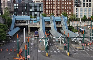
The Downtown Seattle Transit Tunnel (DSTT), also referred to as the Metro Bus Tunnel, is a 1.3-mile-long (2.1 km) pair of public transit tunnels in Seattle, Washington, United States. The double-track tunnel and its four stations serve Link light rail trains on the 1 Line as it travels through Downtown Seattle. It runs west under Pine Street from 9th Avenue to 3rd Avenue, and south under 3rd Avenue to South Jackson Street. 1 Line trains continue north from the tunnel to Northgate station and south through the Rainier Valley past Seattle–Tacoma International Airport to Angle Lake station as part of Sound Transit's light rail network.

<span class="mw-page-title-main">King County Metro</span> Public transit operator in King County, Washington, US

King County Metro, officially the King County Metro Transit Department and often shortened to Metro, is the public transit authority of King County, Washington, which includes the city of Seattle. It is the eighth-largest transit bus agency in the United States. In 2022, the system had a ridership of 66,022,200, or about 244,500 per weekday as of the third quarter of 2023. Metro employs 2,444 full-time and part-time operators and operates 1,540 buses.

<span class="mw-page-title-main">Transportation in Seattle</span> Overview of transportation modes and routes in Seattle, Washington, U.S.

Transportation in Seattle is largely focused on the automobile like many other cities in western North America; however, the city is just old enough for its layout to reflect the age when railways and trolleys predominated. These older modes of transportation were made for a relatively well-defined downtown area and strong neighborhoods at the end of several former streetcar lines, now mostly bus lines.

<span class="mw-page-title-main">1 Line (Sound Transit)</span> Light rail line serving Seattle, Washington

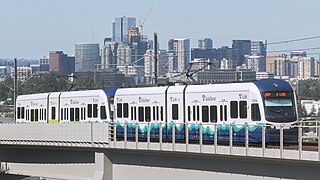
The 1 Line, formerly Central Link, is a light rail line in Seattle, Washington, United States, and part of Sound Transit's Link light rail system. It serves 19 stations in the cities of Seattle, SeaTac, and Tukwila, traveling nearly 25 miles (40 km) between Northgate and Angle Lake stations. The line connects the University District, Downtown Seattle, the Rainier Valley, and Seattle–Tacoma International Airport. The 1 Line carried over 26 million total passengers in 2023, with an average of nearly 80,000 daily passengers on weekdays. It runs for 20 hours per day on weekdays and Saturdays, with headways of up to six minutes during peak hours, and reduced 18-hour service on Sundays and holidays.

<span class="mw-page-title-main">Seattle Convention Center</span> Municipal convention center in Seattle, Washington

The Seattle Convention Center (SCC), formerly the Washington State Convention Center (WSCC), is a convention center in Seattle, Washington, United States. It consists of two buildings in Downtown Seattle with exhibition halls and meeting rooms: Arch along Pike Street and Summit on the north side of Pine Street. The former straddles Interstate 5 and connects with Freeway Park. The convention center was planned in the late 1970s and funded through $90 million in bonds issued by the state legislature.

<span class="mw-page-title-main">2 Line (Sound Transit)</span> Light rail line under construction in the Seattle metropolitan area

The East Link Extension, also known as the 2 Line, is a future light rail line serving the Eastside region of the Seattle metropolitan area in the U.S. state of Washington. It will be part of Sound Transit's Link light rail system, running 18 miles (29 km) from west to east and serving 12 stations in Downtown Seattle, Mercer Island, Bellevue, and Redmond. The first section of the 2 Line, between South Bellevue and Redmond Technology stations, is scheduled to open in 2024. It is planned to be followed in 2025 by an extension east to Downtown Redmond and west to Seattle, where it will continue into the Downtown Seattle Transit Tunnel and share stations with the 1 Line through to Lynnwood City Center station.

<span class="mw-page-title-main">Mount Baker station</span> Light rail station in Seattle, Washington

Mount Baker station is a light rail station located in Seattle, Washington. It is situated between the Columbia City and Beacon Hill stations on the 1 Line, which runs from Seattle–Tacoma International Airport to Downtown Seattle, the University of Washington, and Northgate as part of the Link light rail system. The elevated station consists of two side platforms located west of the intersection of Rainier Avenue and Martin Luther King Jr. Way in the Mount Baker neighborhood, part of Seattle's Rainier Valley.

<span class="mw-page-title-main">SODO station (Sound Transit)</span> Light rail station in Seattle, Washington

SODO station is a light rail station located in Seattle, Washington. It is situated between the Beacon Hill and Stadium stations on the 1 Line, which runs from Seattle–Tacoma International Airport to Downtown Seattle and the University of Washington as part of the Link light rail system. The station consists of two at-grade side platforms at the intersection of the SODO Busway and South Lander Street in the SoDo neighborhood of Seattle.
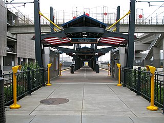
<span class="mw-page-title-main">International District/Chinatown station</span> Light rail station in Seattle, Washington

International District/Chinatown station is a light rail station that is part of the Downtown Seattle Transit Tunnel in Seattle, Washington, United States. The station is located at the tunnel's south end, at 5th Avenue South and South Jackson Street in the Chinatown-International District neighborhood, and is served by the 1 Line of Sound Transit's Link light rail system. The station is located adjacent to Sound Transit headquarters at Union Station, as well as intermodal connections to Amtrak and Sounder commuter rail at King Street Station and the First Hill Streetcar.

<span class="mw-page-title-main">Kent station (Sound Transit)</span> Commuter train station in Kent, Washington

Kent station is a train station in the city of Kent, Washington, United States, served by the S Line of the Sounder commuter rail network. It is located in downtown Kent and consists of two train platforms connected via a pedestrian overpass, a parking garage, and several bus bays. The station also has 996 parking stalls and is served by King County Metro and Sound Transit Express buses. Train service to Kent began in 2001 and the station's garage opened the following year. King County Metro began service from the bus bays in 2005, after a third phase of construction. Sound Transit plans to build a second parking garage in 2027 to accommodate additional demand at the station.

<span class="mw-page-title-main">Pioneer Square station</span> Light rail station in Seattle, Washington

Pioneer Square station is a light rail station that is part of the Downtown Seattle Transit Tunnel in Seattle, Washington, United States. The station is located under 3rd Avenue at James Street, between University Street and International District/Chinatown stations. It is served by the 1 Line, part of Sound Transit's Link light rail system, and provides connections to local buses and Colman Dock, a major ferry terminal serving areas west of Seattle.

<span class="mw-page-title-main">University Street station</span> Light rail station in Seattle, Washington

University Street station is a light rail station that is part of the Downtown Seattle Transit Tunnel in Seattle, Washington, United States. The station is located under 3rd Avenue at University Street, near Benaroya Hall, and is served by Sound Transit's 1 Line. It is located between Westlake and Pioneer Square stations and has surface connections to buses operated by King County Metro and other providers.

<span class="mw-page-title-main">Westlake station (Sound Transit)</span> Light rail station in Seattle, Washington

Westlake station is a light rail station that is part of the Downtown Seattle Transit Tunnel in Seattle, Washington, United States. The station is located under Pine Street between 3rd and 6th avenues in Downtown Seattle, near Westlake Center and Westlake Park. It is served by the 1 Line, part of Sound Transit's Link light rail system, and also connected above ground by buses at several stops, the South Lake Union Streetcar, and the Seattle Center Monorail.

<span class="mw-page-title-main">University of Washington station</span> Light rail station in Seattle, Washington

University of Washington station is a light rail station on the University of Washington campus in Seattle, Washington, United States. The station is served by the 1 Line of Sound Transit's Link light rail system, which connects Northgate, Downtown Seattle, and Seattle–Tacoma International Airport. University of Washington station is at the intersection of Montlake Boulevard Northeast and Northeast Pacific Street, adjacent to Husky Stadium and the University of Washington Medical Center.

<span class="mw-page-title-main">Capitol Hill station</span> Light rail station in Seattle, Washington

Capitol Hill station is a light rail station in the Capitol Hill neighborhood of Seattle, Washington, United States. The station is served by Sound Transit's Link light rail system and is located near the intersection of Broadway and East John Street. It is situated between the Westlake and University of Washington stations on the 1 Line. The station consists of an island platform approximately 65 feet (20 m) under street level, connected to three surface entrances via two mezzanines. It contains pieces of public art, including Mike Ross's sculpture Jet Kiss and two murals by cartoonist Ellen Forney.

<span class="mw-page-title-main">Northgate station (Sound Transit)</span> Light rail and bus station in Seattle, Washington, U.S.

Northgate is a light rail and bus station in the Northgate neighborhood of Seattle, Washington, United States. It is the northern terminus of the 1 Line on Sound Transit's Link light rail system. The transit center, located adjacent to the Northgate Mall, has four bus bays served by 22 routes. The station also has parking for 1,525 vehicles.

<span class="mw-page-title-main">Bellevue Transit Center</span> Bus station and future light rail station in downtown Bellevue, Washington

Bellevue Transit Center (BTC) is a bus station and future light rail station in Bellevue, Washington, a suburb of Seattle. It is the main transit hub for the Eastside of King County, serving 20 routes from King County Metro and Sound Transit Express. The transit center is the western terminus of the RapidRide B Line, which runs east to Redmond.

<span class="mw-page-title-main">Route 41 (King County Metro)</span> Urban bus route in Seattle, Washington

Route 41 was an express bus route operated by King County Metro in Seattle, Washington, United States. It connected Lake City and Northgate to Downtown Seattle, with non-stop service on Interstate 5 south of Northgate Transit Center.

<span class="mw-page-title-main">SODO Busway</span> Busway corridor in Seattle, Washington

The SODO Busway, also referred to as the E-3 Busway, is a 1.5-mile-long (2.4 km) busway in the SoDo neighborhood of Seattle, Washington. It has four stops, including two that connect to Link light rail stations, and functions as an extension of the Downtown Seattle Transit Tunnel, which was formerly used by buses. The busway is served by ten bus routes—seven King County Metro routes from southern King County and three Sound Transit Express routes from Pierce County.

<span class="mw-page-title-main">Pine Street</span> East–west street in Seattle, Washington, U.S.

Pine Street is a major east–west street in Seattle, Washington, United States. It travels parallel to Pike Street between Downtown Seattle and the retail core to Capitol Hill, the Central District, and Madrona.

References

  1. Lane, Bob (July 29, 1979). "Metro takes new look at bus tunnel". The Seattle Times . p. A22.
  2. Gough, William (November 27, 1982). "New transit mall could ease downtown traffic". The Seattle Times. p. A9.
  3. Gough, William (November 4, 1983). "Metro Council OK's downtown transit tunnel". The Seattle Times. p. B1.
  4. Gough, William (October 7, 1983). "Metro chief urges a city tunnel for electric buses". The Seattle Times. p. B1.
  5. Nogaki, Sylvia; Gough, William (January 14, 1984). "Metro chooses bus-station sites, hits snag over downtown tunnel". The Seattle Times. p. A8.
  6. Lane, Polly (March 21, 1984). "Panel affirms Freeway site for state convention center". The Seattle Times. p. G1.
  7. 1 2 Draft Environmental Impact Statement for the Downtown Seattle Transit Project. Urban Mass Transit Administration and Municipality of Metropolitan Seattle. March 1984. pp. 3–14, 5–20. OCLC   42982574 . Retrieved March 19, 2018 via Google Books.
  8. 1 2 Lane, Bob (February 3, 1987). "Big dig will close Pine St. to buses". The Seattle Times. p. C1.
  9. Lane, Bob (August 30, 1985). "Metro driving forward with tunnel". The Seattle Times. p. B2.
  10. Lane, Bob (April 25, 1987). "Pine Street in downtown area to be off limits to most traffic". The Seattle Times. p. A8.
  11. Lane, Bob (December 31, 1987). "Jackhammers will take over Pine Street again". The Seattle Times. p. E3.
  12. Lane, Bob (February 12, 1988). "Almost finished 3 blocks of tunnel". The Seattle Times. p. D1.
  13. "Progress reported on Metro bus tunnel". The Seattle Times. December 12, 1988. p. B3.
  14. Lane, Bob (June 7, 1990). "Deafening silence: Bus tunnel's done". The Seattle Times. p. B1. Archived from the original on March 3, 2016. Retrieved March 19, 2018.
  15. Macdonald, Patrick (September 14, 1990). "Bochinche goes underground for Metro bus tunnel". The Seattle Times. p. 8. Archived from the original on February 2, 2017. Retrieved March 19, 2018.
  16. Rosenwald, Lonnie (September 15, 1990). "Seattle opens glitzy new bus tunnel today". The Spokesman-Review . Spokane, Washington: Cowles Publishing Company. p. A9. Retrieved March 19, 2018 via Google News Archive.
  17. Winfield, Phyllis (September 16, 1990). "It's tunnel time: Bus riders check it out". The Seattle Times. p. B2.
  18. Lane, Bob (September 11, 1990). "The Metro Mission: Easy riders". The Seattle Times. p. A4.
  19. Stiffler, Lisa (May 28, 2004). "King County's new hybrid buses debut". Seattle Post-Intelligencer . p. B2. Archived from the original on March 20, 2018. Retrieved March 19, 2018.
  20. 1 2 3 4 The Book: Transit Operating Handbook (PDF). King County Metro. February 2011. pp. 726–729. Archived (PDF) from the original on February 26, 2018. Retrieved March 19, 2018 via Seattle Transit Blog.
  21. Pryne, Eric (October 13, 2005). "Bus-tunnel error years ago is costly in shutdown today". The Seattle Times. Archived from the original on February 2, 2017. Retrieved March 19, 2018.
  22. Williams, Marla; Schaefer, David (May 30, 1993). "Transit plan paves costly road to future". The Seattle Times. p. B1.
  23. Schaefer, David (October 6, 1996). "Looking at the new transit proposal". The Seattle Times. p. A1. Archived from the original on September 18, 2017. Retrieved March 19, 2018.
  24. Schaefer, David (November 6, 1996). "Voters back transit plan on fourth try". The Seattle Times. p. A1. Archived from the original on March 3, 2016. Retrieved March 19, 2018.
  25. Varner, Lynne K.; Schaefer, David (September 25, 1998). "Plan to convert tunnel for trains wins support". The Seattle Times. p. B3.
  26. Fryer, Alex (November 19, 1999). "A milestone for light rail: Regional board selects station sites, alignment". The Seattle Times. p. A1.
  27. 1 2 Dudley, Brier (April 26, 2000). "Transit station sits on valuable land". The Seattle Times. p. B2. Archived from the original on March 20, 2018. Retrieved March 19, 2018.
  28. Garber, Andrew (April 13, 2001). "Light rail can't be built as planned". The Seattle Times. p. A1. Archived from the original on March 20, 2018. Retrieved March 19, 2018.
  29. Dudley, Brier (November 18, 2000). "Price puts tunnel on hold". The Seattle Times. p. A1. Archived from the original on August 14, 2017. Retrieved March 19, 2018.
  30. Brunner, Jim (June 29, 2001). "Sound Transit looks south for its first line". The Seattle Times. p. B1. Archived from the original on August 14, 2017. Retrieved March 19, 2018.
  31. "Sound Transit Motions No. M2001-103" (PDF). Sound Transit. September 27, 2001. Archived (PDF) from the original on March 20, 2018. Retrieved March 19, 2018.
  32. "Amended Record of Decision for Central Puget Sound Regional Transit Authority's (Sound Transit) Initial Segment of the Central Link Light Rail Transit Project" (PDF). Federal Transit Administration. May 8, 2002. Archived (PDF) from the original on December 27, 2016. Retrieved March 19, 2018 via Global Telematics.
  33. "Sound Transit Motion No. M2002-69" (PDF). Sound Transit. May 23, 2002. Archived (PDF) from the original on July 26, 2017. Retrieved March 19, 2018.
  34. "Sound Transit eliminates a route option". Seattle Post-Intelligencer. May 24, 2002. p. B2. Archived from the original on March 20, 2018. Retrieved March 19, 2018.
  35. "Chapter 2: Alternatives Considered" (PDF). North Link Draft Supplemental Environmental Impact Statement (Report). Sound Transit. March 2006. p. 2-1. OCLC   61880055. Archived (PDF) from the original on September 10, 2017. Retrieved March 19, 2018.
  36. Gilmore, Susan (September 23, 2005). "Bus tunnel shuts down tonight for 2 years". The Seattle Times. p. A1. Archived from the original on February 2, 2017. Retrieved March 19, 2018.
  37. Lange, Larry (October 31, 2005). "Getting There: Hybrid Operated Vehicles—or so one driver hopes". Seattle Post-Intelligencer. p. B1. Archived from the original on March 20, 2018. Retrieved March 19, 2018.
  38. "Sound Transit Motion No. M2007-101 Staff Report" (PDF). Sound Transit. September 20, 2007. Archived (PDF) from the original on March 20, 2018. Retrieved March 19, 2018.
  39. Pryne, Eric (January 6, 2005). "Digging is 1st sign light rail coming to town". The Seattle Times. p. B1. Archived from the original on February 2, 2017. Retrieved March 19, 2018.
  40. Gilmore, Susan (September 25, 2007). "Reopening of downtown Seattle bus tunnel goes smoothly". The Seattle Times. Archived from the original on February 2, 2017. Retrieved March 19, 2018.
  41. "Sound Transit Motion No. M2004-78 Staff Report" (DOC). Sound Transit. August 12, 2004. Archived from the original on March 20, 2018. Retrieved March 19, 2018.
  42. Nogaki, Sylvia (September 30, 1984). "Foot for foot, downtown transit project would be the costliest in the nation". The Seattle Times. pp. A1–A4.
  43. Nabbefeld, Joe (December 19, 1999). "Transit stations lure developers". Puget Sound Business Journal. Archived from the original on April 16, 2003. Retrieved March 19, 2018.
  44. "Convention Place Station TOD". King County Metro. July 1, 2005. Archived from the original on November 15, 2006. Retrieved March 19, 2018.
  45. "King County Metro Six-Year Transit Development Plan" (PDF). King County Metro. September 2002. p. D-16. Archived (PDF) from the original on December 27, 2016. Retrieved March 19, 2018.
  46. "King County Metro Transit Division 2004 LEED Assessment". King County Metro. 2005. p. 5. Archived from the original on March 19, 2018. Retrieved March 19, 2018.
  47. Brunner, Jim (December 2, 2008). "Expanded convention center's cost: $766 million". The Seattle Times. p. A8. Archived from the original on March 20, 2018. Retrieved March 19, 2018.
  48. Brunner, Jim (January 5, 2009). "Does convention center really need to grow again?". The Seattle Times. p. A1. Archived from the original on March 20, 2018. Retrieved March 19, 2018.
  49. Brunner, Jim (May 1, 2009). "State convention center expansion put on hold". The Seattle Times. p. B1. Archived from the original on March 20, 2018. Retrieved March 19, 2018.
  50. LMN Architects (August 15, 2013). "Washington State Convention Center Expansion Feasibility Study Draft Report, Part Two: Background and Analysis" (PDF). Washington State Department of Commerce. pp. 5–6. Archived (PDF) from the original on December 27, 2016. Retrieved March 19, 2018.
  51. Stiles, Marc (March 28, 2013). "Washington State Convention Center eyes Honda site for expansion". Puget Sound Business Journal. Archived from the original on April 5, 2017. Retrieved March 19, 2018.
  52. Bhatt, Sanjay (June 5, 2014). "Hotels could transform key downtown Seattle corridor". The Seattle Times. p. A1. Archived from the original on December 16, 2014. Retrieved March 19, 2018.
  53. Levy, Nat (June 13, 2014). "Convention center's expansion may include office, hotel towers" . Seattle Daily Journal of Commerce . Archived from the original on March 20, 2018. Retrieved March 19, 2018.
  54. Bhatt, Sanjay (November 18, 2015). "King County Metro, convention center reach $147M deal on site's sale". The Seattle Times. p. B1. Archived from the original on February 22, 2017. Retrieved March 19, 2018.
  55. 1 2 Lindblom, Mike (June 27, 2017). "King County agrees to sell downtown Seattle bus station for convention center expansion". The Seattle Times. p. B2. Archived from the original on June 30, 2017. Retrieved June 27, 2017.
  56. Lindblom, Mike (May 8, 2018). "Buses could be evicted from the downtown bus tunnel next spring, but Seattle streets might not be ready". The Seattle Times. p. A6. Archived from the original on May 8, 2018. Retrieved May 8, 2018.
  57. 1 2 "Metro bus stops at Convention Place Station will be relocated on July 21; buses expected to continue to operate in the Downtown Seattle Transit Tunnel through March 2019" (Press release). King County Metro. July 6, 2018. Retrieved July 6, 2018.
  58. Lindblom, Mike (July 20, 2018). "Downtown Seattle bus station closes for good Saturday. Here's where to find the buses". The Seattle Times. Retrieved July 20, 2018.
  59. Switzer, Jeff (June 30, 2017). "What the new timeline for Convention Place Station means for riders". King County Metro. Archived from the original on March 20, 2018. Retrieved March 19, 2018.
  60. "Convention Place Station Construction: Frequently asked questions". King County Metro. Archived from the original on August 14, 2017. Retrieved March 19, 2018.
  61. 1 2 Lindblom, Mike (June 25, 2017). "Reprieve for tunnel riders, but cascading projects to multiply Seattle's traffic woes". The Seattle Times. p. B1. Archived from the original on June 25, 2017. Retrieved June 26, 2017.
  62. Stiles, Marc (January 2, 2014). "Convention Center pays $56.5M for downtown Seattle property". Puget Sound Business Journal . Archived from the original on March 13, 2017. Retrieved March 19, 2018.
  63. 1 2 3 Downtown Metro Service: Frequent Routes to Help You Get Around Downtown (PDF) (Map). King County Metro. September 2016. Archived (PDF) from the original on October 6, 2014. Retrieved March 19, 2018.
  64. 1 2 Central Link Operations Plan — Westlake to SeaTac/Airport (PDF) (Report). Sound Transit. July 29, 2008. pp. 10–12, 55. Archived (PDF) from the original on September 24, 2015. Retrieved March 19, 2018.
  65. 1 2 3 4 5 Transit Tunnel: Convention Place Station (PDF) (Map). King County Metro Transit. October 2015. Archived from the original (PDF) on April 21, 2015. Retrieved March 19, 2018.
  66. "Washington State Convention Center Addition: Transportation Discipline Report" (PDF). Washington State Convention Center. February 2017. p. 4. Archived (PDF) from the original on March 20, 2018. Retrieved March 19, 2018.
  67. Guillen, Tomas; Ervin, Keith (September 25, 1990). "Wrong-way bus has close call". The Seattle Times. p. A1. Archived from the original on March 20, 2018. Retrieved March 19, 2018.
  68. 1 2 3 4 5 6 "Convention Place Station—the Meeting Place". King County Metro. Archived from the original on September 9, 2015. Retrieved March 19, 2018.
  69. Tarzan, Deloris (January 30, 1986). "Tunnel visions: Art projects unveiled in $1.5 million proposal for underground busing". The Seattle Times. p. D1.
  70. Tarzan, Deloris (June 12, 1987). "Get a case of "tunnel art" vision at Seattle Center House". The Seattle Times. p. 7.
  71. Lane, Bob (December 21, 1989). "Art tunnel: Metro installs murals, fancy fixtures to make bus stations a visual treat". The Seattle Times. p. C1.
  72. Mathieson, Karen (September 12, 1990). "Tunnel Visions: Bus labyrinth beneath Seattle spawns gallery". The Seattle Times. p. C1. Archived from the original on October 6, 2014. Retrieved March 19, 2018.
  73. Healy, Tim (1990). An Extraordinary Guide to Seattle's New Underground. Municipality of Metropolitan Seattle. OCLC   26488542.
  74. Artifacts: Public Art in Seattle's New Underground. Municipality of Metropolitan Seattle. 1988. pp. 6–7. OCLC   22895595.
  75. "Metro Station Waterfall (sculpture)". SIRIS Art Inventories Catalog. Smithsonian American Art Museum . Retrieved February 17, 2019.
  76. "Metro Arts Program Proposed 1996 Arts Plan" (PDF). King County Council. March 29, 1996. p. 12. Archived (PDF) from the original on February 17, 2017. Retrieved March 19, 2018.
  77. Wilson, Gemma (December 19, 2023). "How objects unearthed beneath Seattle Convention Center became art". The Seattle Times. Archived from the original on December 19, 2023. Retrieved December 19, 2023.
  78. "King County Metro Transit Development Plan: 2015–2020" (PDF). King County Metro. September 2016. p. 5. Archived (PDF) from the original on March 20, 2018. Retrieved March 19, 2018 via Washington State Department of Transportation.
  79. Regional Transit Map Book (PDF) (Map). Sound Transit. February 2014. pp. 10–11. Archived from the original (PDF) on July 28, 2017. Retrieved March 19, 2018.
  80. Surface Street Bus Stops When the Downtown Seattle Transit Tunnel is Closed (PDF) (Map). King County Metro. Archived (PDF) from the original on October 7, 2014. Retrieved March 19, 2018.