
Chatsworth is a township municipality in Grey County, in southwestern Ontario, Canada. The township is located at the headwaters of the Styx River, the Saugeen River, the Sauble River, the Bighead River, the Spey River, and the old Sydenham River.

Queenston is a compact rural community and unincorporated place 5 kilometres (3.1 mi) north of Niagara Falls in the Town of Niagara-on-the-Lake, Ontario, Canada. It is bordered by Highway 405 to the south and the Niagara River to the east; its location at the eponymous Queenston Heights on the Niagara Escarpment led to the establishment of the Queenston Quarry in the area. Across the river and the Canada–US border is the village of Lewiston, New York. The Lewiston-Queenston Bridge links the two communities. This village is at the point where the Niagara River began eroding the Niagara Escarpment. During the ensuing 12,000 years the Falls cut an 11 kilometres (6.8 mi) long gorge in the Escarpment southward to its present-day position.

Larder Lake is an incorporated municipal township and eponymous constituent dispersed rural community in Timiskaming District in Northeastern Ontario, Canada. It is located along Ontario Highway 66 and Ontario Highway 624 at the north-western part of the lake bearing the same name. The area of the township is 229.65 km2 (88.67 sq mi) and includes the geographic townships of Hearst, McVittie and Skead.

Severn is a township in south-central Ontario, Canada, located between Lake Couchiching, and the Severn River in Simcoe County.
Baden is a suburban community and unincorporated place in Township of Wilmot, Regional Municipality of Waterloo in Southwestern Ontario, Canada. It was named after Baden-Baden, Germany; the approximate population as of 2015, as per township statistics, is 4,940.

Bala is a compact rural community in the township municipality of Muskoka Lakes, District Municipality of Muskoka in Central Ontario, Canada. It is well-known for the Bala Falls, the source of the Moon River, which flows from Lake Muskoka to the Georgian Bay.
Pakesley is a dispersed rural community and ghost town in geographic Mowat Township in the Unorganized Centre Part of Parry Sound District of Ontario, Canada. Located at the junction of Ontario Highway 522 and the Parry Sound subdivision of the Canadian Pacific Railway, it is named for the Pakeshkag River that drains the local area north to the Pickerel River. Formerly a station and passing track on the CPR, this portion of the line from Bala to Sudbury was opened to traffic June 15, 1908.
Balaclava is a dispersed rural community in the township municipality of Bonnechere Valley, Renfrew County, in Eastern Ontario, Canada. It is on the former Ontario Highway 513 just off Ontario Highway 132 north of the community of Dacre, and at the outlet of Constant Creek, a tributary of the Madawaska River, from Constant Lake, approximately 30 minutes drive time from the town of Renfrew.
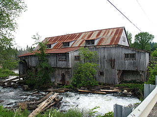
Flinton is a hamlet in and the seat of the municipality of Addington Highlands, Lennox and Addington County in Eastern Ontario, Canada. The population is about 500, and it was founded by Billa Flint. The community is on the Skootamatta River whose falls were used to power many mills. The eponymous Flinton Creek runs nearby and joins the Skootamatta downstream of the community.

South Algonquin is a township municipality in Nipissing District, Ontario, Canada. Located south of Algonquin Provincial Park, it is the sole populated portion of the district that lies south of the traditional dividing line between Northern Ontario and Southern Ontario and is closer connected to Renfrew County as opposed to the core portions of Nipissing District.

Bayfield is a community in the municipality of Bluewater, Huron County in southwestern Ontario, Canada with a 2016 population of 1,112. Bluewater Municipality includes Bayfield, Bruce field, Dashwood, Hensall, Varna, and Zurich This municipality is made up of 92.8% English speaking people, 6.3% of other language speaking people and 0.9% of French speaking people as of 2016. In addition to this the majority of Bayfield's population is made up of Canadians, creating 88.2% of the population in the year 2016. It is on the eastern shore of Lake Huron at the mouth of Bayfield River. Bayfield is a popular tourist destination. Visitors enjoy the historic Main Street with its many well-preserved old buildings, including the Little Inn which has served travelers since the 1800s, initially as a stagecoach stop. Main Street is lined with boutique shops, art galleries and fine dining restaurants. The nearby marina and public beaches draw crowds in the summer months.
Rosedale is a Dispersed Rural Community and unincorporated place located in the city of Kawartha Lakes, Ontario, Canada, 29 kilometres (18 mi) north-west of Lindsay. It is partly in geographic Fenelon Township and partly in Somerville Township, and is on the Rosedale River, part of the Trent–Severn Waterway, where that river drains Balsam Lake on its way to Cameron Lake.
Kashabowie is an unincorporated place and Compact Rural Community in southwestern Thunder Bay District in Northwestern Ontario, Canada. It is on the Canadian National Railway Kashabowie Subdivision main line, built originally as the Canadian Northern Railway transcontinental main line, between the Planet flag stop to the west and the Postans flag stop to the east, and has a passing siding.

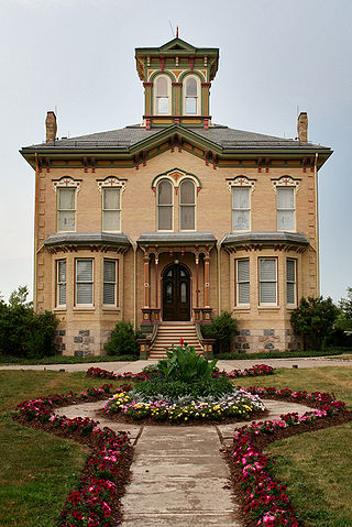
Eugenia is a small community in the municipality of Grey Highlands, Grey County, in Southwestern Ontario, Canada, located just north of the community of Flesherton. An unincorporated hamlet of Artemesia Township for most of its history, Eugenia was amalgamated into the Grey Highlands in 2001. Due to nearby Lake Eugenia, Eugenia Falls, the Bruce Trail and the ski resorts of the Beaver Valley, it has become a popular tourist and cottage destination. The nearby Eugenia Power Station has the highest head of water of any hydroelectric generator in Ontario, and has provided a significant amount of electricity to the provincial grid for a century.
Departure Lake is a dispersed rural community and unincorporated place in geographic Haggart Township, Cochrane District in Northeastern Ontario, Canada. It is located on Ontario Highway 11 between the communities of Strickland to the west and Smooth Rock Falls to the east.

Sauble Falls Provincial Park is located in the town of South Bruce Peninsula, Bruce County in southwestern Ontario, Canada, 36 kilometres (22 mi) west of Owen Sound. It is in the lower drainage basin of the Sauble River, which flows into Lake Huron. The campground consists of two sections divided by County Road 13. The west section of the site is a quiet zone. Group camping is available in the east section. Many sites along the east portion of the park back up against the Sauble River. The park is also the downstream terminus of the Rankin River canoe route.
Bervie is an unincorporated place and Compact Rural Community in the municipality of Kincardine, Bruce County in southwestern Ontario, Canada. It is located on Ontario Highway 9, and is on the Penetangore River, which flows to Lake Huron at the town centre of Kincardine.

The Black River is a river in Cochrane District and Timiskaming District in Northeastern Ontario, Canada. It is part of the James Bay drainage basin, and is a right tributary of the Abitibi River. The municipality of Black River-Matheson is named after the river.
The Matawin River is a river in Thunder Bay District in Northwestern Ontario, Canada. It is in the Great Lakes Basin and is a right tributary of the Kaministiquia River.
The Kashabowie River is a river in southwestern Thunder Bay District in Northwestern Ontario, Canada. It is in the Great Lakes Basin and is a tributary of the Shebandowan Lakes.
