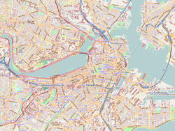
The North End is a neighborhood of Boston, Massachusetts, United States. It is the city's oldest residential community, having been inhabited since it was colonized in the 1630s. It is only 0.36 square miles (0.93 km2), yet the neighborhood has nearly one hundred establishments and a variety of tourist attractions. It is known for its Italian American population and Italian restaurants.

Copp's Hill is an elevation in the historic North End of Boston, Massachusetts. It is bordered by Hull Street, Charter Street and Snow Hill Street. The hill takes its name from William Copp, a shoemaker who lived nearby. Copp's Hill Burying Ground is a stop on the Freedom Trail.

Beacon Hill is a historic neighborhood in Boston, Massachusetts, United States. It is also the location of the Massachusetts State House. The term "Beacon Hill" is used locally as a metonym to refer to the state government or the legislature itself, much like Washington, D.C.'s Capitol Hill does at the federal level.

The Charles River Reservation is a 17-mile-long (27 km) urban preserve and public recreation area located along the banks of the Charles River in Boston, Cambridge, Watertown, and Newton, Massachusetts. The reservation is managed by the Massachusetts Department of Conservation and Recreation.

The Arborway consists of a four-lane, divided parkway and a two-lane residential street in the Jamaica Plain neighborhood of Boston, Massachusetts, United States. It was designed by Frederick Law Olmsted in the 1890s as the southern-most carriage road in a series of parkways connecting parks from Boston Common in downtown Boston to Franklin Park in Roxbury. This park system has since become known as the Emerald Necklace.

The North End Parks are the two northernmost parks on the Rose Kennedy Greenway, built over O'Neill Tunnel in Boston, Massachusetts and adjacent to the neighborhood known as the North End. Two landscape architecture firms designed the 3-acre (12,000 m2) North End Parks.

Copp's Hill Burying Ground is a historic cemetery in the North End of Boston, Massachusetts. Established in 1659, it was originally named "North Burying Ground", and was the city's second cemetery.
The Bulfinch Triangle Historic District is a historic district roughly bounded by Canal, Market, Merrimac, and Causeway Streets in the West End of Boston, Massachusetts. The entire district was laid out by architect Charles Bulfinch on land reclaimed from the old Mill Pond, and is now populated by well-preserved commercial buildings from the 1870s through early 1900s. It was added to the National Register of Historic Places in 1986.

The Neponset Valley Parkway is a historic parkway in southern Boston and Milton, Massachusetts, United States. It is a connecting parkway in the Greater Boston area's network, providing a connection between the Blue Hills Reservation, Neponset River Reservation, and the Stony Brook Reservation. The parkway was constructed between 1898 and 1929 with design assistance from Charles Eliot and the Olmsted Brothers. It was listed on the National Register of Historic Places in 2005.
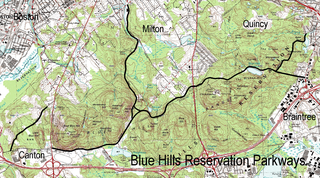
The Blue Hills Reservation Parkways are a network of historic parkways in and around the Blue Hills Reservation, a Massachusetts state park south of Boston, Massachusetts. It consists of six roadways that provide circulation within the park, and that join the park to two connecting parkways, the Blue Hills Parkway and the Furnace Brook Parkway. The roadway network was designed by Charles Eliot in the 1890s, except for Green Street, which was added to the network in the 1940s. The parkways were added to the National Register of Historic Places in 2003.

The Charles River Reservation Parkways are parkways that run along either side of the Charles River in eastern Massachusetts. The roads are contained within the Charles River Reservation and the Upper Charles River Reservation, and fall within a number of communities in the greater Boston metropolitan area. The Charles River parks extend from the Charles River Dam, where the Charles empties into Boston Harbor, to Riverdale Park in the West Roxbury neighborhood of Boston. Most of the roadways within the parks are listed on the National Register of Historic Places as a unit, although Storrow Drive and Memorial Drive are listed as part of the Charles River Basin Historic District.

Furnace Brook Parkway is a historic parkway in Quincy, Massachusetts. Part of the Metropolitan Park System of Greater Boston, it serves as a connector between the Blue Hills Reservation and Quincy Shore Reservation at Quincy Bay. First conceived in the late nineteenth century, the state parkway is owned and maintained by the Massachusetts Department of Conservation and Recreation (DCR) and travels through land formerly owned by the families of John Adams and John Quincy Adams, passing several historic sites. It ends in the Merrymount neighborhood, where Quincy was first settled by Europeans in 1625 by Captain Richard Wollaston. The road was started in 1904, completed in 1916 and added to the National Register of Historic Places (NRHP) in 2004.

Blue Hills Parkway is a historic parkway that runs in a straight line from a crossing of the Neponset River, at the south border of Boston to the north edge of the Blue Hills Reservation in Milton, Massachusetts. It was built in 1893 to a design by the noted landscape architect, Charles Eliot, who is perhaps best known for the esplanades along the Charles River. The parkway is a connecting road between the Blue Hills Reservation and the Neponset River Reservation, and was listed on the National Register of Historic Places in 2003.

Hammond Pond Parkway is a historic parkway in Chestnut Hill, Massachusetts. The road, built in 1932, extends 2 miles (3.2 km) from Hobart Road in Newton to Horace James Circle in Brookline, where it joins the West Roxbury Parkway. It was designed by Charles Eliot and the Olmsted Brothers to provide a parkway setting that provided access from Brookline, Newton, and the western portions of Boston to the southern parks of the Emerald Necklace. The parkway was listed on the National Register of Historic Places in 2004.

The Metropolitan Park System of Greater Boston is a system of reservations, parks, parkways and roads under the control of the Massachusetts Department of Conservation and Recreation (DCR) in and around Boston that has been in existence for over a century. The title is used by the DCR to describe the areas collectively: "As a whole, the Metropolitan Park System is currently eligible for listing on the National Register of Historic Places", as outlined on the department's website. The DCR maintains a separate Urban Parks and Recreation division to oversee the system, one of five such divisions within the department—DCR's Bureau of State Parks and Recreation manages the remainder of Massachusetts state parks. Direct design and maintenance functions for the parkways and roads within the system are provided by the DCR Bureau of Engineering.

Stony Brook Reservation is a woodland park in Boston and Dedham, Massachusetts, a unit of the Metropolitan Park System of Greater Boston, part of the state park system of Massachusetts. It was established in 1894 as one of the five original reservations created by the Metropolitan Park Commission. The park is served by the Stony Brook Reservation Parkways, a road system that was entered into the National Register of Historic Places in 2006.

The Blossom Hill and Calvary Cemeteries are a pair of adjacent municipally-owned cemeteries on North State Street in Concord, New Hampshire. Blossom Hill, a 19th-century cemetery designed in the then-fashionable rural cemetery tradition, was always a municipal cemetery; the Calvary Cemetery was established by the Roman Catholic Diocese of Manchester, whose oversight area includes all of New Hampshire. The Calvary Cemetery was taken over by the city in 1996; its earliest marked grave dates to 1857. The cemeteries were listed on the National Register of Historic Places in 2010.

Clementina Poto Langone (1896–1964) was a civic leader from the North End of Boston who is remembered for her service to the Italian-American community. During the Great Depression she was known as a "Good Samaritan" who distributed food and clothing to the poor and advocated for them politically. As a member of the Massachusetts Board of Immigration and Americanization, she helped hundreds of Italian immigrants assimilate and obtain U.S. citizenship. She served as vice chairman of the Massachusetts Democratic State Committee and as an alternate delegate to the Democratic National Convention.

Langone Park is a waterfront park in the North End of Boston, Massachusetts. Established in 1973, it is named for Massachusetts state senator Joseph A. Langone, Jr. and his wife Clementina Langone. The park features a Little League Baseball field, a playground, and three bocce courts. It is located on Commercial Street at the edge of Boston Harbor, immediately to the west of the Andrew P. Puopolo Jr. Athletic Field.