
The Dwight D. Eisenhower National System of Interstate and Defense Highways, commonly known as the Interstate Highway System, or the Eisenhower Interstate System, is a network of controlled-access highways that forms part of the National Highway System in the United States. The system extends throughout the contiguous United States and has routes in Hawaii, Alaska, and Puerto Rico.

In the United States, a farm-to-market road or ranch-to-market road is a state highway or county road that connects rural or agricultural areas to market towns. These are better-quality roads, usually a highway, that farmers and ranchers use to transport products to market towns or distribution centers. Historically used throughout the country, today the term is primarily associated with a large state-maintained highway system in Texas.
Florida's Turnpike, designated as unsigned State Road 91, is a controlled-access toll road in the U.S. state of Florida, maintained by Florida's Turnpike Enterprise (FTE). Spanning approximately 309 miles (497 km) along a northwest–southeast axis, the turnpike is in two sections. The SR 91 mainline runs roughly 265 miles (426 km), from its southern terminus at an interchange with Interstate 95 (I-95) in Miami Gardens to an interchange with I-75 in Wildwood at its northern terminus. The Homestead Extension of Florida's Turnpike continues from the southern end of the mainline for another 48 miles (77 km) to US Highway 1 in Florida City. The slogan for the road is "The Less Stressway". The mainline opened in stages between 1957 and 1964, while the extension was completed in 1974. The turnpike runs through Miami, Fort Lauderdale, and West Palm Beach, where it parallels I-95, and through Orlando, where it crosses I-4.

The State Highway System of the U.S. state of Florida comprises the roads maintained by the Florida Department of Transportation (FDOT) or a toll authority. The components are referred to officially as state roads, abbreviated as SR.

A county highway is a road in the United States and in the Canadian province of Ontario that is designated and/or maintained by the county highway department. Route numbering can be determined by each county alone, by mutual agreement among counties, or by a statewide pattern.

The state highway system of the U.S. state of Oregon is a network of highways that are owned and maintained by the Highway Division of the Oregon Department of Transportation (ODOT).
The South Carolina State Highway System is the fourth largest state-maintained system of state highways in the country. It consists of Interstates, U.S. highways, state highways, and secondary roads, totaling approximately 41,500 miles (66,800 km).

A supplemental route is a state secondary road in the U.S. state of Missouri, designated with letters. Supplemental routes were various roads within the state which the Missouri Department of Transportation was given in 1952 to maintain in addition to the regular routes, though lettered routes had been in use from at least 1932. The four types of roads designated as Routes are:

Texas state highways are a network of highways owned and maintained by the U.S. state of Texas. The Texas Department of Transportation (TxDOT) is the state agency responsible for the day-to-day operations and maintenance of the system. Texas has the largest state highway system, followed closely by North Carolina's state highway system. In addition to the nationally numbered Interstate Highways and U.S. Highways, the highway system consists of a main network of state highways, loops, spurs, and beltways that provide local access to the other highways. The system also includes a large network of farm to market roads that connect rural areas of the state with urban areas and the rest of the state highway system. The state also owns and maintains some park and recreational roads located near and within state and national parks, as well as recreational areas. All state highways, regardless of classification, are paved roads. The Old San Antonio Road, also known as the El Camino Real, is the oldest highway in the United States, first being blazed in 1691. The length of the highways varies from US 83's 893.4 miles (1,437.8 km) inside the state borders to Spur 200 at just 0.05 miles long.

The state highway system of the U.S. state of Virginia is a network of roads maintained by the Virginia Department of Transportation (VDOT). As of 2006, the VDOT maintains 57,867 miles (93,128 km) of state highways, making it the third-largest system in the United States.

Transportation in the Commonwealth of Virginia is by land, sea and air. Virginia's extensive network of highways and railroads were developed and built over a period almost 400 years, beginning almost immediately after the founding of Jamestown in 1607, and often incorporating old established trails of the Native Americans.

The North Carolina Highway System consists of a vast network of Interstate, United States, and state highways, managed by the North Carolina Department of Transportation. North Carolina has the second largest state maintained highway network in the United States because all roads in North Carolina are maintained by either municipalities or the state. Since counties do not maintain roads, there is no such thing as a "county road" within the state.
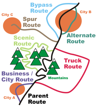
In road transportation in the United States, a special route is a road in a numbered highway system that diverts a specific segment of related traffic away from another road. They are featured in many highway systems; most are found in the Interstate Highway System, U.S. highway system, and several state highway systems. Each type of special route possesses generally defined characteristics and has a defined relationship with its parent route. Typically, special routes share a route number with a dominant route, often referred as the "parent" or "mainline", and are given either a descriptor which may be used either before or after the route name, such as Alternate or Business, or a letter suffix that is attached to the route number. For example, an alternate route of U.S. Route 1 may be called "Alternate U.S. Route 1", "U.S. Route 1 Alternate", or "U.S. Route 1A". Occasionally, a special route will have both a descriptor and a suffix, such as U.S. Route 1A Business.

The Byrd Road Act was an Act of Assembly passed in February 1932 by the Virginia General Assembly. Named for former Governor Harry F. Byrd, the legislation was originally presented as measure to relieve the financial pressures of the Great Depression upon the counties, as the state offered to take over responsibility and control of most county roads, creating the Virginia Secondary Roads System.
The State Route System of Tennessee is maintained and developed by the Tennessee Department of Transportation (TDOT) in the U.S. state of Tennessee. Currently the state has 14,150 miles (22,770 km) of state-maintained roadways, including 1,233 miles (1,984 km) of Interstate Highways and 13,077 miles (21,045 km) of State Highways. All of the U.S. Routes in Tennessee have a state route routed concurrently with them, though the state route is hidden and only signed along the green mile marker signs that display mileage within each county. The state route system in Tennessee was established in 1923. Since the 1983 renumbering, state routes have been divided into primary and secondary routes with separate shields used for each.

The State Highways of Washington in the U.S. state of Washington comprise a network of over 7,000 miles (11,270 km) of state highways, including all Interstate and U.S. Highways that pass through the state, maintained by the Washington State Department of Transportation (WSDOT). The system spans 8.5% of the state's public road mileage, but carries over half of the traffic. All other public roads in the state are either inside incorporated places or are maintained by the county. The state highway symbol is a white silhouette of George Washington's head.

The primary highway system makes up over 9,000 miles (14,000 km), approximately 8 percent of the U.S. state of Iowa's public road system. The Iowa Department of Transportation is responsible for the day-to-day maintenance of the primary highway system, which consists of Interstate Highways, United States Highways, and Iowa state highways. Currently, the longest primary highway is U.S. Highway 30 at 332 miles (534 km). The shortest highway is Interstate 129 at 0.27 miles (430 m).
On July 1, 2003, the Iowa Department of Transportation transferred control of more than 700 miles (1,100 km) of highway to county and local governments in order to save money and to increase operational efficiency. Most of the highways turned over were short spurs connecting small, rural communities and state parks to the highway system.
