List of county roads in Lee County, Florida

Last updated

Lee County 78.svg Lee County 865.svg
Standard route marker for county routes in Lee County
Highway names
Interstates Interstate X (I-X)
US Highways U.S. Route X (US X)
State State Road X (NY X)
County:County Road X (CR X)
System links

The following is a list of county roads in Lee County, Florida , United States. As with most Florida counties, numbers are assigned in a statewide grid. Many roads are former state roads that have been truncated or eliminated. County roads are maintained by the Lee County Department of Transportation (Lee County DOT). [1]

Contents

County Road 78

Lee County 78.svg

County Road 78

Location Pine Island CenterCape Coral and
North Fort MyersAlva [2]
Length19 mi [3] [4]  (31 km)
Existed1980–present

County Road 78 exists in two sections that were both formerly State Road 78. [5] The western section runs along Pine Island Road from SR 78  / CR 765  / CR 884 in Cape Coral to CR 767 in Pine Island Center, and the eastern section runs along North River Road from SR 31 in North Fort Myers to the Hendry County line in Alva, continuing east into Hendry County.

County Road 78A

Lee County 78A.svg

County Road 78A

Location Cape CoralNorth Fort Myers [2]
Length3.6 mi [6]  (5.8 km)
Existed1980–present

County Road 78A is Pondella Road from SR 78 in Cape Coral to U.S. Route 41 Business in North Fort Myers. It provides a quicker way for motorists traveling east on SR 78 to access Downtown Fort Myers. The road was known as SR 78A before 1980. [5]

County Road 765

Lee County 765.svg

County Road 765

Location Cape CoralBurnt Store Marina [2]
Length9.2 mi [7]  (14.8 km)

County Road 765 is Burnt Store Road in northwest Cape Coral.

Route description

Burnt Store Road begins in northwest Cape Coral at an intersection with Pine Island Road (SR 78/CR 78) and Veterans Parkway (CR 884). From here, it heads north as a four-lane divided roadway with a wide median. Ater its intersection with Van Buren Parkway, Burnt Store Road is reduced to a two-lane divided road and it continues north. It passes the community of Burnt Store Marina before crossing into Charlotte County, where it continues north to Punta Gorda. [7]

History

The road is named after the community of Burnt Store Marina, whose name refers to a general store and trading post operated by early settlers that once stood in the general vicinity. The trading post was burned down by a small group of Seminole Indians led by Chief Billy Bowlegs in protest of settlers taking their land. [8]

Burnt Store Road was designated as part of SR 183 when it was added to the state highway system. [9] After the 1945 Florida state road renumbering, the road became SR 765. [5] It later became CR 765 when it was relinquished to county control in the 1980s.

Much of Burnt Store Road was moved to its current alignment in the early 1960s. The original alignment, which is now Old Burnt Store Road, was located a mile to the west. [10]

The southern section of Burnt Store Road was widened to four lanes in the late 2010s and early 2020s. [11]

Major intersections

Locationmi [7] kmDestinationsNotes
Cape Coral 0.000.00East plate.svg
Florida 78.svg
West plate county.svg
CR 78 jct.svg
East plate county.svg
CR 884 jct.svg
SR 78 east / CR 78 west (Pine Island Road) / CR 884 east (Veterans Parkway)
Western terminus of CR 884
Burnt Store Marina 9.2014.81North plate county.svg
CR 765 jct.svg
CR 765 north (Burnt Store Road)
Continuation into Charlotte County
1.000 mi = 1.609 km; 1.000 km = 0.621 mi

County Road 767

Lee County 767.svg

County Road 767

Location St. James CityBokeelia [2]
Length14.6 mi [12]  (23.5 km)

County Road 767, also known as Stringfellow Road, is the main north-south road running the length of Pine Island. [5]

Route description

Stringfellow Road begins in St. James City, the unincorporated community on the south end of Pine Island. From St. James City, it runs north along the length of Pine Island. At Pine Island Center, Stringfellow Road intersects with Pine Island Road (CR 78), which runs east to the main land over the Pine Island Causeway. Continuing north, Stringfellow Road passes Pineland before coming to its north terminus in Bokeelia, the community on the north end of Pine Island. [12]

History

Stringfellow Road is named for Harry Stringfellow, a Lee County commissioner from Pine Island who served from 1926 to 1953. Before Pine Island was connected to the main land, Commissioner Stringfellow would have to travel from his home in Pineland via a mule-drawn wagon to St. James City to catch a steamboat to Fort Myers for county commission meetings. This process would often take all day one-way, meaning that Stringfellow was away from home for county commission meeting for days at a time. It was for this reason he championed the construction of the Pine Island Causeway to improve transportation to and on Pine Island. [13]

The road was added to the state highway system in 1931 with the designation of SR 183. The designation became SR 767 during the 1945 Florida state road renumbering. [14] SR 767 was later relinquished to county control in the 1980s.

Major intersections

Locationmi [12] kmDestinationsNotes
St. James City 0.000.00York RoadSouthern terminus of county maintenance
Pine Island Center 7.5012.07East plate county.svg
CR 78 jct.svg
CR 78 east (Pine Island Road)
Western terminus of CR 78; former SR 78
Bokeelia 14.6023.50Main StreetNorthern terminus at northern tip of Pine Island
1.000 mi = 1.609 km; 1.000 km = 0.621 mi

County Road 771

Unsigned CR 771, formerly part of SR 771, is Gasparilla Road [15] extending north from Boca Grande to the Charlotte County line on Gasparilla Island.

County Road 810

Lee County 810.svg

County Road 810

Location Fort Myers–near Buckingham [2]
Length1.2 mi [16]  (1.9 km)

County Road 810 exists along Luckett Road from CR 865 (Ortiz Avenue) in Fort Myers to Country Lakes Drive west of Buckingham.

The road is maintained by the Lee County DOT, except for the interchange with I-75, which is maintained by Florida DOT. [2]

Major intersections

Locationmi [16] kmDestinationsNotes
Fort Myers 0.000.00CR 865 jct.svgTo plate.svg
Florida 80.svg
To plate.svg
Florida 82.svg
CR 865 (Ortiz Avenue) to SR 80  / SR 82
0.801.29I-75.svg I-75  Tampa, Naples Exit 139 on I-75
1.201.93Country Lakes Drive / Luckett Road east
1.000 mi = 1.609 km; 1.000 km = 0.621 mi

County Road 840

Lee County 840.svg

County Road 840

Locationnear San Carlos Park–near Estero [2]
Length11.1 mi [17]  (17.9 km)

County Road 840 is Alico Road from US 41 (Tamiami Trail) just west of San Carlos Park to CR 850 (Corkscrew Road) east of Estero.

County Road 850

Lee County 850.svg

County Road 850

Location Estero–near Immokalee [2]
Length15.8 mi [18]  (25.4 km)

County Road 850 is Corkscrew Road from US 41 (Tamiami Trail) in Estero to the Collier County line near Immokalee, where it continues east into Collier County towards Immokalee.

County Road 863

Lee County 863.svg

County Road 863

Location Fort Myers [2]
Length1.8 mi [19]  (2.9 km)

County Road 863 is the county-controlled segment of Fowler Street south of Hanson Street within the city limits of Fort Myers. North of Hanson Street, Fowler is state-controlled and is part of State Road 739.

County Road 865

Lee County 865.svg

County Road 865

Location Bonita SpringsFort Myers Beach, IonaTice [2]
Length35.9 mi [20] [21] [22]  (57.8 km)

County Road 865 exists in three sections. The southernmost section runs along Bonita Beach Road through Bonita Springs, Hickory Boulevard though Bonita Beach, and Estero Boulevard though Fort Myers Beach. The central section travels along Gladiolus Drive through Iona, Harlem Heights, and Biggar before ending at US 41 (Tamiami Trail). The northern section runs along Ben C. Pratt Six Mile Cypress Parkway and Ortiz Avenue from SR 739 to SR 80 in Tice. The segments were once part of a continuous SR 865. [5]

County Road 867

Lee County 867.svg

County Road 867

Location Punta RassaIona [2]
Length4.8 mi [23]  (7.7 km)

County Road 867 is McGregor Boulevard from the Sanibel Causeway in Punta Rassa to SR 867 in Iona.

The road was formerly known as SR 867, [24] a designation which still exists on a section of McGregor Boulevard from Iona to McGregor.

County Road 867A

Lee County 867A.svg

County Road 867A

Location McGregorCape Coral and
North Fort Myers [2]
Length12.8 mi [25] [26]  (20.6 km)

County Road 867A begins at McGregor Boulevard (SR 867) and crosses the Cape Coral Bridge into Cape Coral where it briefly runs along Cape Coral Parkway. It then runs north along Del Prado Boulevard though Cape Coral and North Fort Myers.

County Road 869

Lee County 869.svg

County Road 869

Location IonaFort Myers [2]
Length11.7 mi [27]  (18.8 km)

County Road 869 is the designation for Summerlin Road which runs from just east of Punta Rassa to Fort Myers.

County Road 876

Lee County 876.svg

County Road 876

Location McGregorFort Myers Shores [2]
Length23.0 mi [28]  (37.0 km)

County Road 876 runs along Cypress Lake Drive and Daniels Parkway just south of Fort Myers. It then runs along Gunnery Road through Lehigh Acres and Buckingham Road though Buckingham.

County Road 881

Lee County 881.svg

County Road 881

Location Bonita SpringsThree Oaks [2]
Length13.6 mi [29]  (21.9 km)

County Road 881 is the largely unsigned designation along Imperial Parkway though Bonita Springs and Three Oaks Parkway through Estero and Three Oaks. The entire route is controlled by Lee County, except for the short segment between Bonita Beach Road and East Terry Street which is controlled by the city of Bonita Springs. [2]

County Road 882

Lee County 882.svg

County Road 882

Location McGregorVillas [2]
Length2.4 mi [30]  (3.9 km)

County Road 882 is an east-west route just south of Fort Myers. It is locally known as College Parkway and it runs 2.4 miles from McGregor Boulevard (SR 867) to U.S. Route 41. [31] Its name is due to its proximity to Florida SouthWestern State College (originally Edison Community College). CR 882's western terminus is an interchange with McGregor Boulevard, with the route continuing west as CR 867A over the Cape Coral Bridge. College Parkway also has an interchange with Summerlin Road (CR 869). CR 882 is only signed at its interchange with Summerlin Road (CR 869). [32]

Major intersections

Locationmi [30] kmDestinationsNotes
McGregor 0.000.00Florida 867.svg SR 867 (McGregor Boulevard)continues west as CR 867A
Whiskey Creek 1.542.48CR 869 jct.svg CR 869 (Summerlin Road)Interchange
Villas 2.373.81US 41.svg US 41 (South Cleveland Avenue)
1.000 mi = 1.609 km; 1.000 km = 0.621 mi

County Road 884

Lee County 884.svg

County Road 884

Location Cape CoralFort Myers and
Fort MyersAlva [2]
Length32.5 mi [33] [34]  (52.3 km)

County Road 884 exists in two sections. The western section runs through Cape Coral along the Veterans Parkway before crossing the Midpoint Bridge on to Colonial Boulevard in Fort Myers. The western section terminates at US 41 (Cleveland Avenue) in Fort Myers. The eastern section continues along Colonial Boulevard just east of Interstate 75. The eastern section then runs through Lehigh Acres along Lee Boulevard, Leeland Heights Boulevard, and Joel Boulevard to Alva.

County Road 885

Lee County 885.svg

County Road 885

Location EsteroFort Myers [2]
Length13.00 mi [35]  (20.92 km)

County Road 885 runs along Ben Hill Griffin Parkway and Treeline Avenue in Estero and the east side of Fort Myers.

Route Description

CR 885 begins at Corkscrew Road (CR 850) in Estero. From here, it heads north as a four-lane road named Ben Hill Griffin Parkway paralleling Interstate 75. It passes Miromar Outlets, Florida Gulf Coast University, and Gulf Coast Town Center before intersecting Alico Road (CR 840). Just north of Alico Road, it intersects with Terminal Access Road, which is the main entrance to Southwest Florida International Airport. North of Terminal Access Road, CR 885 is known as Treeline Avenue and it continues north. It intersects Daniels Parkway (CR 876) and passes some residential communities before terminating at Colonial Boulevard (CR 884) on the east side of Fort Myers. [35]

History

The first major segment of CR 885 to be completed was Ben Hill Griffin Parkway between Alico and Corkscrew Roads. It was named for Ben Hill Griffin, Jr., former chairman of Alico Inc., whose land was partially donated by Griffin's son Ben Hill Griffin III to the state for the construction of Florida Gulf Coast University. [36] Ben Hill Griffin Parkway was completed by 1997 in conjunction with the opening of the university, as it was the main access road.

Treeline Avenue, which originally was a short local road off Daniels Parkway, was extended south and connected to Ben Hill Griffin Parkway in early 2005 in conjunction with the construction of the current terminal at Southwest Florida International Airport. Treeline Avenue was later extended to Colonial Boulevard in 2006.

CR 885 was the primary access to Southwest Florida International Airport until 2015, when Terminal Access Road was extended west to connect directly to Interstate 75. [37]

Major intersections

Locationmi [35] kmDestinationsNotes
Estero 0.000.00CR 850 jct.svgTo plate blue.svg
I-75.svg
CR 850 (Corkscrew Road) to I-75
4.306.92CR 840 jct.svgTo plate blue.svg
I-75.svg
CR 840 (Alico Road) to I-75
5.609.01Airport Sign.svg Terminal Access Road Southwest Florida International Airport Partial diamond interchange; former at-grade intersection
8.0012.87CR 876 jct.svgTo plate blue.svg
I-75.svg
CR 876 (Daniels Parkway) to I-75  Fort Myers, Cape Coral, Gateway, Lehigh Acres, Tampa, Naples
Fort Myers 13.0020.92CR 884 jct.svg CR 884 (Colonial Boulevard)
1.000 mi = 1.609 km; 1.000 km = 0.621 mi

County Road 887

Lee County 887.svg

County Road 887

Location Bonita Springs [2]
Length5.3 mi [38]  (8.5 km)

County Road 887 is the former designation for Old 41 Road from the Collier County line north through Bonita Springs to US 41.

Route description

The former CR 887 begins at the Lee/Collier county line, where it continues north from the Collier County segment of CR 887. It heads north and intersects Bonita Beach Road (CR 865) and passes through Downtown Bonita Springs. It terminates at US 41 (Tamiami Trail) in northern Bonita Springs. [38]

History

The road was originally a routing of Tamiami Trail (US 41) through Downtown Bonita Springs. After US 41 was rerouted to its present alignment in 1976, the former route was redesignated SR 887. [5] SR 887 was turned over to county control in both Lee and Collier Counties in the early 1980s. Bonita Springs became an incorporated city in 1999, and all of CR 887 in Lee County is now controlled by the City of Bonita Springs. [2] While the designation has been largely decommissioned in Lee County, the CR 887 designation is still signed in Collier County.

The SR 887 designation has since been reused for the Port Miami Tunnel since its opening on August 3, 2014. [39]

Major intersections

The entire route is in Bonita Springs.

mi [38] kmDestinationsNotes
0.000.00South plate county.svg
CR 887 jct.svg
CR 887 south (Old 41 Road)
Continuation into Collier County
1.201.93CR 865 jct.svgTo plate blue.svg
I-75.svg
CR 865 (Bonita Beach Road) to I-75
5.308.53US 41.svg US 41 (Tamiami Trail)
1.000 mi = 1.609 km; 1.000 km = 0.621 mi

See also

Related Research Articles

<span class="mw-page-title-main">Lee County, Florida</span> County in Florida, United States

Lee County is a county located in southwestern Florida, United States, on the Gulf Coast. As of the 2020 census, its population was 760,822. In 2022, the population was 822,453, making it the eighth-most populous county in the state. The county seat is Fort Myers, with a population of 86,395 as of the 2020 census, and the largest city is Cape Coral, with an estimated 2020 population of 194,016.

<span class="mw-page-title-main">Midpoint Memorial Bridge</span> Bridge in Florida, United States of America

The Midpoint Memorial Bridge is a bridge located in Southwest Florida. It spans the Caloosahatchee River, connecting Fort Myers and Cape Coral. It is a four-lane fixed span that is 1.125 miles (1.811 km) long. The bridge's name comes from serving as a midpoint or middle bridge for the Cape Coral bridges – Cape Coral Bridge is south, and the Caloosahatchee Bridge is located north. It carries County Road 884, which is known as Colonial Boulevard on the Fort Myers side, and Veterans Parkway on the Cape Coral side.

<span class="mw-page-title-main">Florida State Road 80</span> Highway in Florida

State Road 80 is a 123.5 miles (198.8 km) route linking US 41 Business in Fort Myers and State Road A1A in Palm Beach. The road is the northernmost of three linking Southwest Florida to South Florida via the Everglades. Due to increasing traffic, State Road 80 has experienced upgrades and widening in various sections since 2000.

<span class="mw-page-title-main">Florida State Road 78</span> State highway in Florida, United States

State Road 78 is the Florida Department of Transportation designation of the highway that historically extended from Pine Island Center on the Gulf Coast of Florida to the northern tip of Lake Okeechobee. In the 1980s, two segments of the route were removed from state maintenance to county maintenance and both were redesignated County Road 78. All three sections of SR 78 are signed east–west, even though the easternmost section is actually a north–south route.

<span class="mw-page-title-main">Florida State Road 884</span> State highway in Florida, United States

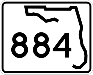
State Road 884, along with County Road 884, together create Lee County, Florida's primary east–west partially controlled access highway, linking Cape Coral in the western portion of the county to Lehigh Acres and Alva in the eastern portion. Currently, the highway consists of State Road 884, and two segments of County Road 884 on each end, and the entire highway is about 37.5 miles (60.4 km) long. The highway runs through the southern incorporated limits of the city of Fort Myers and through the mid part of Cape Coral, and has become a major commuter route.

<span class="mw-page-title-main">Florida State Road 82</span> Highway in Florida

State Road 82 is a 29-mile-long east–west highway serving northern Lee and Collier County, Florida. The western terminus is an intersection with Cleveland Avenue in Fort Myers; the eastern terminus is an intersection with SR 29 midway between Immokalee and Felda.

<span class="mw-page-title-main">Florida State Road 865</span> State highway in Florida, United States

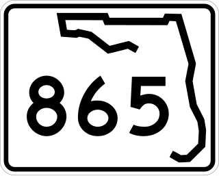
State Road 865 and County Road 865 are a series of roads serving Lee County, Florida. Originally a continuous state road extending from Bonita Springs to Tice by way of Fort Myers Beach and Fort Myers, SR 865 now consists of two segments connected by a part of CR 865, which also extends to the north and south of the state segments. Both the state and county controlled segments of the route combined stretch a distance of over 40 miles (64.37 km), making it the longest designation in Lee County.

<span class="mw-page-title-main">McGregor Boulevard</span>

State Road 867 and County Road 867 together create a 14.6-mile (23.5 km) long road known as McGregor Boulevard in Lee County, Florida, paralleling the Caloosahatchee River between Punta Rassa and Fort Myers. The entire road was formerly state-maintained.

<span class="mw-page-title-main">Florida State Road 739</span> State highway in Florida, United States

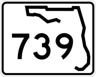
State Road 739 is a 17-mile-long (27 km) commercial highway running from San Carlos Park, Florida to North Fort Myers that is also known as U.S. Route 41 Business for the northernmost six miles (9.7 km) of its route.

<span class="mw-page-title-main">U.S. Route 1 in Florida</span> Highway in Florida

U.S. Highway 1 (US 1) in Florida runs 545 miles (877 km) along the state's east coast from Key West to its crossing of the St. Marys River into Georgia north of Boulogne and south of Folkston. US 1 was designated through Florida when the U.S. Numbered Highway System was established in 1926. With the exception of Monroe County, the highway runs through the easternmost tier of counties in the state, connecting numerous towns and cities along its route, including nine county seats. The road is maintained by the Florida Department of Transportation (FDOT).

<span class="mw-page-title-main">U.S. Route 19 in Florida</span> Highway in Florida

U.S. Highway 19 (US 19) runs about 262 miles (422 km) along Florida's west coast from an interchange with US 41 in Memphis, south of Tampa, and continues to the Georgia border north of Monticello.

<span class="mw-page-title-main">Pine Island Causeway</span> Bridge in Florida, United States of America

The Pine Island Causeway is a roadway in Southwest Florida spanning Matlacha Pass connecting Pine Island, the largest island in Florida, to the main land in Cape Coral. The causeway carries Pine Island Road and consists of three bridges with dredged land sections in between them. The islands connected to the middle of the causeway are also home to the community of Matlacha. It provides the only vehicular access to both Matlacha and Pine Island.

<span class="mw-page-title-main">County Road 876 (Lee County, Florida)</span>

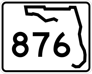
County Road 876 is a major county road in Lee County, Florida spanning 22.92 miles (36.89 km). It is major east-west thoroughfare just south of Fort Myers city limits before becoming a north-south route through Lehigh Acres and Buckingham. The east-west portion is locally known as Cypress Lake Drive west of U.S. Route 41 and Daniels Parkway east of there. The north-south segment is known as Gunnery Road through Lehigh Acres and Buckingham Road through Buckingham.

<span class="mw-page-title-main">County Road 881 (Florida)</span> County road in Florida, United States

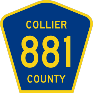
County Road 881 (CR 881) is a major thoroughfare in Southwest Florida. It is one of three major routes connecting Collier and Lee counties along with US Highway 41 and Interstate 75 (I-75). Locally, it is known as Livingston Road in Collier County and Imperial Parkway and Three Oaks Parkway in Lee County. The route is fully signed in Collier County, but is only signed sparingly in Lee County.

<span class="mw-page-title-main">Summerlin Road</span> County road in Lee County, Florida, United States

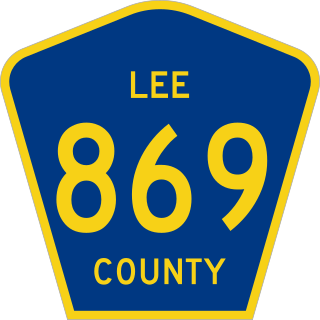
Summerlin Road, also designated as County Road 869 (CR 869), is a major roadway in Lee County, Florida. It serves as a route connecting Fort Myers with the southwestern portion of the county near Punta Rassa. It provides access to the islands of Fort Myers Beach, Sanibel and Captiva.

<span class="mw-page-title-main">Corkscrew Road</span> Road in Florida, United States

Corkscrew Road, also designated as County Road 850 (CR 850), is a major road in Southwest Florida running from Estero in Lee County east to a point near Immokalee in Collier County. The western section is the primary east–west road in Estero.

References

  1. "Lee County Department of Transportation". Lee County, Florida. Retrieved 29 May 2024.
  2. 1 2 3 4 5 6 7 8 9 10 11 12 13 14 15 16 17 18 19 20 21 Road Maintenance System (Map). Cartography by Lee County GIS. Lee County Department of Transportation . Retrieved April 20, 2016.
  3. Google (February 2, 2014). "CR 78 (Western Section)" (Map). Google Maps . Google. Retrieved February 2, 2014.
  4. Google (February 2, 2014). "CR 78 (Eastern Section)" (Map). Google Maps . Google. Retrieved February 2, 2014.
  5. 1 2 3 4 5 6 General Highway Map, Lee County, January 1976, reprinted January 1980
  6. Google (February 2, 2014). "CR 78A" (Map). Google Maps . Google. Retrieved February 2, 2014.
  7. 1 2 3 Google (February 2, 2014). "CR 765" (Map). Google Maps . Google. Retrieved February 2, 2014.
  8. "The Legend of Burnt Store". Burnt Store Marina - Century 21 Sunbelt Realty. Retrieved 17 June 2015.
  9. "Lee, 1936" (PDF). Florida Center for Instructional Technology. University of South Florida. Retrieved February 27, 2024.
  10. State Road Department of Florida (1960). Official State Road Map of Florida (PDF) (Map). Scale not given. Tallahassee: State Road Department of Florida. Retrieved May 22, 2024.
  11. "Home". Burnt Store Road Widening Project. Lee County Department of Transportation. Retrieved 24 May 2024.
  12. 1 2 3 Google (October 13, 2014). "CR 767" (Map). Google Maps . Google. Retrieved October 13, 2014.
  13. "People of influence: Harry Stringfellow". 6 September 2014. Retrieved 7 May 2024.
  14. "Pre-1945 state roads 165-201". NE2. Retrieved 8 May 2024.
  15. FDOT right of way map, section 12660-2601
  16. 1 2 Google (October 13, 2014). "CR 810" (Map). Google Maps . Google. Retrieved October 13, 2014.
  17. Google (October 13, 2014). "CR 840" (Map). Google Maps . Google. Retrieved October 13, 2014.
  18. Google (October 13, 2014). "CR 850" (Map). Google Maps . Google. Retrieved October 13, 2014.
  19. Google (October 13, 2014). "CR 863" (Map). Google Maps . Google. Retrieved October 13, 2014.
  20. Google (December 28, 2017). "CR 865 (Southern Section)" (Map). Google Maps . Google. Retrieved December 28, 2017.
  21. Google (December 28, 2017). "CR 865 (Middle Section)" (Map). Google Maps . Google. Retrieved December 28, 2017.
  22. Google (December 28, 2017). "CR 865 (Northern Section)" (Map). Google Maps . Google. Retrieved December 28, 2017.
  23. Google (October 13, 2014). "CR 867" (Map). Google Maps . Google. Retrieved October 13, 2014.
  24. FDOT right of way map, section 12040-2501
  25. Google (April 29, 2024). "CR 867A (Southern Section)" (Map). Google Maps . Google. Retrieved April 29, 2024.
  26. Google (October 13, 2014). "CR 867A (Northern Section)" (Map). Google Maps . Google. Retrieved October 13, 2014.
  27. Google (October 13, 2014). "CR 869" (Map). Google Maps . Google. Retrieved October 13, 2014.
  28. Google (October 13, 2014). "CR 876" (Map). Google Maps . Google. Retrieved October 13, 2014.
  29. Google (October 13, 2014). "CR 881" (Map). Google Maps . Google. Retrieved October 13, 2014.
  30. 1 2 Google (April 25, 2024). "CR 882" (Map). Google Maps . Google. Retrieved April 25, 2024.
  31. "Lee County Road 867A". AA Roads. Retrieved 26 April 2024.
  32. Google (June 2022). "Summerlin Road, approaching College Parkway (CR 882)". Google Street View . Google. Retrieved April 25, 2015.
  33. Google (October 13, 2014). "CR 884 (Western Section)" (Map). Google Maps . Google. Retrieved October 13, 2014.
  34. Google (October 13, 2014). "CR 884 (Eastern Section)" (Map). Google Maps . Google. Retrieved October 13, 2014.
  35. 1 2 3 Google (October 13, 2014). "CR 885" (Map). Google Maps . Google. Retrieved October 13, 2014.
  36. Silverstein, Adam (2013-03-25). "Florida vs. FGCU: The Griffin family connection". Only Gators Get Out Alive. Retrieved 10 April 2015.
  37. Ruane, Laura (5 March 2015). "SWFL International, I-75 connector opens". The News-Press. Retrieved 3 May 2024.
  38. 1 2 3 Google (October 14, 2014). "CR 887" (Map). Google Maps . Google. Retrieved October 14, 2014.
  39. Newland, Maggie (August 2, 2014). "Tunnel To PortMiami Opening Sunday Morning". WFOR-TV. Retrieved October 14, 2014.