Interstate 4 (I-4) is an Interstate Highway located entirely within the U.S. state of Florida, maintained by the Florida Department of Transportation (FDOT). Spanning 132.298 miles (212.913 km) along a generally southwest–northeast axis, I-4 is entirely concurrent with State Road 400 (SR 400). In the west, I-4 begins at an interchange with I-275 in Tampa. I-4 intersects with several major expressways as it traverses Central Florida, including U.S. Route 41 (US 41) in Tampa; US 301 near Riverview; I-75 near Brandon; US 98 in Lakeland; US 192 in Celebration; Florida's Turnpike in Orlando; and US 17 and US 92 in multiple junctions. In the east, I-4 ends at an interchange with I-95 in Daytona Beach, while SR 400 continues for roughly another 4 mi (6.4 km) and ends at an intersection with US 1 on the city line of Daytona Beach and South Daytona.
Interstate 295 (I-295), an auxiliary route of Interstate 95, is a beltway around central Jacksonville, Florida. The 60.9 miles (98.0 km)-long beltway consists of two segments, the West Beltway, and the East Beltway, with I-95 serving as the dividing line between the two. The entire highway carries a hidden designation as State Road 9A by the Florida Department of Transportation. The West Beltway was constructed in the 1970s, with the East Beltway being built from the 1980s-2000s.

Interstate 595 (I-595), also known as the Port Everglades Expressway and as the unsigned State Road 862 (SR 862), is a 12.860-mile (20.696 km) Interstate highway that connects Interstate 75 and Alligator Alley in the west with Florida's Turnpike, Interstate 95, Fort Lauderdale-Hollywood International Airport, US 1, and SR A1A before terminating at Port Everglades in the east. The interstate route was conceived in 1969, and planned as an interstate starting in 1974. Construction began in 1984, with the freeway opening in stages in the late 1980s, with completion in 1991. The reversible tolled express lanes opened in 2014.

The State Highway System of the U.S. state of Florida comprises the roads maintained by the Florida Department of Transportation (FDOT) or a toll authority. The components are referred to officially as state roads, abbreviated as SR.

A county highway is a road in the United States and in the Canadian province of Ontario that is designated and/or maintained by the county highway department. Route numbering can be determined by each county alone, by mutual agreement among counties, or by a statewide pattern.
The state highway system of the U.S. state of Oregon is a network of highways that are owned and maintained by the Highway Division of the Oregon Department of Transportation (ODOT).
State Road 404 (SR 404), the Pineda Causeway, is an east–west divided highway currently running from Interstate 95 (I-95) to SR A1A at Patrick Space Force Base, Florida, US. It was opened as a toll road in 1971 and classified as a state road two years later. The tolls were removed in 1990. It was named after Pineda, a former village east of Suntree on U.S. Route 1 (US 1). With interchanges at US 1 (SR 5), South Tropical Trail, and South Patrick Drive (SR 513), the Pineda Causeway is the primary access for Patrick Space Force Base and the southern end of Merritt Island. From US 1 to the eastern terminus, it is part of the Indian River Lagoon Scenic Highway system.
State Road 997, also known as Krome Avenue and West 177th Avenue is a 36.7-mile-long (59.1 km) north–south state highway in western Miami-Dade County, Florida. It runs from State Road 998 in Homestead north across U.S. Route 41 to U.S. Route 27 near Countyline Dragway, just south of the Broward County line. Its main use is as a bypass around the western side of Miami, linking the routes that run southwest, west and northwest from that city. The road passes through newer suburbs in the southern third of its length, while the northern two thirds of the highway traverse the eastern edge of the Everglades.
Sunset Drive, also known as Southwest 72nd Street is a 12.5-mile-long (20.1 km) east–west arterial road traversing the southwestern suburbs of Miami, Florida, from the northwestern portions of the Kendall area to Coral Gables. A central portion of Sunset Drive is maintained by the Florida Department of Transportation as State Road 986, which runs from the Homestead Extension (HEFT) underpass to Southwest 69th Avenue and is signed through South Miami to US 1.
Interstate 95 (I-95) is the main Interstate Highway of Florida's Atlantic Coast. It begins at a partial interchange with U.S. Highway 1 (US 1) just south of downtown Miami, and heads north past Daytona Beach, through Jacksonville, and to the Georgia state line at the St. Marys River near Becker. The route also passes through the cities of Fort Lauderdale, West Palm Beach, and Titusville.
State Road 228 (SR 228) is a 32.532-mile-long (52.355 km) state highway in the northeastern part of the U.S. state of Florida. It exists in two distinct sections, separated by both Baker County Road 228 and Duval CR 228, which are former segments of SR 228.
State Road 101 (SR 101) is a 1.209-mile-long (1.946 km) state highway in Duval County, in the First Coast part of the U.S. state of Florida. It connects SR A1A to the south side of Naval Station Mayport on Maine Street. Along its route, SR 101 meets the east end of SR 116. At the south end of SR 101, Mayport Road continues on SR A1A to Atlantic Boulevard (SR 10). After going under the SR A1A/SR 10 bridge, Mayport Road becomes Florida Boulevard.
State Road 97 is a south-north two-lane highway entirely in Escambia County, Florida. It runs from County Road 95A, just southeast of U.S. Highway 29 in Molino, to the Alabama state line near Atmore, where it becomes State Route 21. The road runs through the community of Walnut Hill and serves primarily to connect Pensacola to the northwest Escambia County and Atmore areas. In combination with SR 21, the road also provides a connection to Interstate 65.
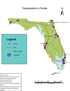
Transportation in Florida includes a variety of options, including Interstate Highways, U.S. Highways, and Florida State Roads; Amtrak and commuter rail services; airports, public transportation, and sea ports, in a number of the state's counties and regions.
