Staffordshire is a landlocked ceremonial county in the West Midlands of England. It borders Cheshire to the north-west, Derbyshire and Leicestershire to the east, Warwickshire to the south-east, the West Midlands county and Worcestershire to the south, and Shropshire to the west. The largest settlement is the city of Stoke-on-Trent, and the county town is Stafford.

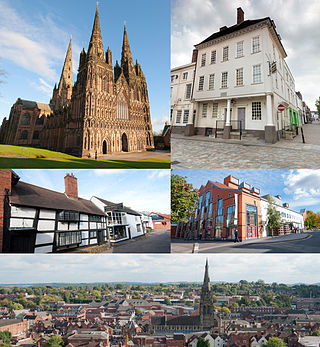
Lichfield is a cathedral city and civil parish in Staffordshire, England. Lichfield is situated 18 miles (29 km) south-east of Stafford, 9 miles (14 km) north-east of Walsall, 8 miles (13 km) north-west of Tamworth and 13 miles (21 km) south-west of Burton upon Trent. At the time of the 2021 Census, the population was 34,738 and the population of the wider Lichfield District was 106,400.

East Staffordshire is a local government district with borough status in Staffordshire, England. The council is based in Burton upon Trent. The borough also contains the town of Uttoxeter and numerous villages and surrounding rural areas.

South Derbyshire is a local government district in Derbyshire, England. The district covers the towns of Melbourne and Swadlincote as well as numerous villages and hamlets such as Hilton, Hatton, Etwall, Aston-on-Trent, Repton, Weston-on-Trent and Willington. About a third of the National Forest lies within the district.

The Borough of Newcastle-under-Lyme is a local government district with borough status in Staffordshire, England.

Cannock Chase is a local government district in Staffordshire, England. It is named after and covers a large part of Cannock Chase, a designated National Landscape. The council is based in the town of Cannock. The district also contains the towns of Hednesford and Rugeley, as well as a number of villages and surrounding rural areas.

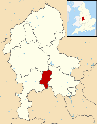
Lichfield District is a local government district in Staffordshire, England. The district is named after its largest settlement, the city of Lichfield, which is where the district council is based. The district also contains the towns of Burntwood and Fazeley, along with numerous villages and surrounding rural areas, including part of Cannock Chase, a designated Area of Outstanding Natural Beauty.

Lichfield is a constituency in Staffordshire represented in the House of Commons of the UK Parliament since 2024 by Dave Robertson of the Labour Party.
Lichfield District Council elections are held every four years. Lichfield District Council is the local authority for the non-metropolitan district of Lichfield in Staffordshire, England. Since the last boundary changes in 2015, 47 councillors have been elected from 22 wards.

Kenton is a suburb and electoral ward in the north west of Newcastle upon Tyne, in the county of Tyne and Wear, England. It borders the Town Moor and Gosforth. Kenton also has close road links to Newcastle Airport. The ward population at the 2011 Census was 11,605.

Rushall is a suburb in the Metropolitan Borough of Walsall in the West Midlands, England. It is centred on the main road between Walsall and Lichfield. It is mentioned in the Domesday Book but has mostly developed since the 1920s. Rushall was historically a part of the county of Staffordshire before it was incorporated with much of the old Aldridge-Brownhills Urban District into the modern-day Walsall district.

Boultham is an inner-city area of Lincoln in Lincolnshire, England. The population of the City of Lincoln ward at the 2021 census was 11,258 this included the areas of New Boultham and Swanpool Garden Suburb.

Tamworth Borough Council is the local authority for the borough of Tamworth in the county of Staffordshire, England. The council consists of 30 councillors, three for each of the 10 wards in the town. It is currently under no overall control, led by Conservative councillor Thomas Jay. The borough council is based at Marmion House.

Boley Park is the name given to the ward and suburb of Lichfield in the Lichfield District and the county of Staffordshire, England. It is one of the six wards on Lichfield City Council and as of September 2024 was represented by Cllrs Andrew Fox (Con), Janet Eagland (Lab), Mark Warfield (Con) and Robert Yardley. (Con).

Chadsmead is the name given to the ward and suburb of Lichfield in the Lichfield District and the ceremonial county of Staffordshire, England. It is one of the six wards on Lichfield City Council and as of September 2024 was represented by Cllrs Claire Pinder-Smith (Lab), Hugh Ashton, Paul Ray and Sam Schafer (Lab).

Leomansley is a ward and suburb of Lichfield in the Lichfield District and the ceremonial county of Staffordshire, England. It is one of the six wards on Lichfield City Council and as of September 2024 was represented by Cllrs Andrew Rushton, Ben Watkins (Lab), Ed Strain (Lab), Jacob Marshall (Lab), James Blackman (Lab) and Jamie Christie.

St John's is a ward and suburb of Lichfield in the Lichfield District and the ceremonial county of Staffordshire, England. It is one of the six wards on Lichfield City Council and as of September 2024 was represented by Cllrs Colin Greatorex (Con), Deb Baker (Con), Jeyan Anketell (Lab), John Smith, Katie Farrelly (Lab) and Rosemary Harvey-Coggins (Lab).

Stowe is a ward and suburb of Lichfield in the Lichfield District, in the county of Staffordshire, England. It is one of the six wards on Lichfield City Council and as of 2024 is represented by Cllrs Angela Lax (Con), Ann Hughes (Lab), Paul McDermott, Russell Bragger (Lab) and Scott Hollingsworth.

Darwin Park is a residential complex and suburb of Lichfield in the Lichfield District in Staffordshire, England. It is located to the southwest of the city centre. It was originally rural land around Lichfield but was built by BHB Architects who built the estate with village-styled streets, houses, retail, community and park uses. It has a Waitrose shop and is within easy access of Falkland Road and the Lichfield Southern Bypass. It was named after Erasmus Darwin who was born and raised in Lichfield. Darwin Park incorporates a footpath, Cathedral Walk which offers a direct traffic-free connection between Lichfield City Centre, Leomansley and St Johns. Darwin Park is also home to a sculpture of Erasmus Darwin which is located in Cathedral Walk.


