Related Research Articles

Oxfordshire is a ceremonial county in South East England. The county is bordered by Northamptonshire and Warwickshire to the north, Buckinghamshire to the east, Berkshire to the south, and Wiltshire and Gloucestershire to the west. The city of Oxford is the largest settlement and county town.
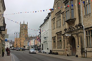
Cotswold is a local government district in Gloucestershire, England. It is named after the wider Cotswolds region and range of hills. The council is based in the district's largest town of Cirencester. The district also includes the towns of Chipping Campden, Fairford, Lechlade, Moreton-in-Marsh, Northleach, Stow-on-the-Wold and Tetbury, along with numerous villages and surrounding rural areas.

South Oxfordshire is a local government district in the ceremonial county of Oxfordshire, England. Its council is temporarily based outside the district at Abingdon-on-Thames pending a planned move to Didcot, the district's largest town. The areas located south of the River Thames are within the historic county of Berkshire.

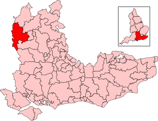
West Oxfordshire is a local government district in northwest Oxfordshire, England, including towns such as Woodstock, Burford, Chipping Norton, Charlbury, Carterton and Witney, where the council is based.

The North Wessex Downs are an area of chalk downland landscapes located in the English counties of Berkshire, Hampshire, Oxfordshire and Wiltshire. The North Wessex Downs has been designated as a National Landscape since 1972.
Witney is a county constituency in Oxfordshire represented in the House of Commons of the Parliament of the United Kingdom. It elects one Member of Parliament by the first-past-the-post system of election, and was created for the 1983 general election.
Curbridge is a village and civil parish immediately southwest of Witney, in the West Oxfordshire district, in the county of Oxfordshire, England. The 2011 Census recorded the parish's population as 529. Since 2012 it has been part of the Curbridge and Lew joint parish council area, sharing a parish council with the adjacent civil parish of Lew.

South Stoke is a village and civil parish on an east bank of the Thames, about 1.5 miles (2.4 km) north of Goring-on-Thames in South Oxfordshire. It includes less than 1 mile (1.6 km) to its north the hamlet and manor house of Littlestoke.

Beckley and Stowood is a civil parish in South Oxfordshire, England. Its area is 9.17 km2. It is 3 miles (4.8 km) northeast of Oxford and 1 mile (1.6 km) west of the M40. The parish is made up of Beckley and Stowood.

Wantage was a rural district of Berkshire, England from 1894 to 1974.
Witney Town F.C. is a football club in Witney, Oxfordshire. The club was founded in 1885 and adopted the name Witney Town in 1922. The club's most successful period was in the 1970s and 80s when they competed in the Southern League Premier Division, finishing 5th in 1983–84. The club folded in 2001, but a phoenix club arose under the name Witney United in 2002 and obtained the lease of the former club's ground. The club readopted the Witney Town name in 2011, but was dissolved during the 2012–13 season while playing in the Hellenic League Premier Division.
Winterbrook is a small settlement in the English county of Oxfordshire, which adjoins the south end of Wallingford and sits on the west bank of the Thames. It is separated from Wallingford by Bradford's Brook. In 1974 it was transferred from Berkshire. Although having been part of the adjacent parish of Cholsey for centuries, its proximity to Wallingford resulted in its being absorbed into that town for administrative purposes in 2015. This change was effected despite the strenuous and long-term objections of the residents. It is now part of the Wallingford ward of South Oxfordshire District Council. It remains in the Church of England parish of St Mary the Virgin, North Stoke.

Lew is a village and civil parish about 2+1⁄2 miles (4 km) southwest of Witney in the West Oxfordshire District of Oxfordshire, England. The 2001 Census recorded the parish population as 65. Since 2012 the parish has been part of the Curbridge and Lew joint parish council area, sharing a parish council with the adjacent civil parish of Curbridge.

Bucklebury Common is an elevated common consisting of woodland with a few relatively small clearings in the English county of Berkshire, within the civil parish of Bucklebury centred 3 miles (4.8 km) northeast of Thatcham and encircling the settled localities of Upper Bucklebury and Chapel Row. It is one of the largest commons in Southern England covering 350 hectares. Since Inclosure the area is privately owned by the Bucklebury Manor estate, but has public access on a network of public rights of way bolstered by the Countryside and Rights of Way Act 2000.
Baldons is a joint parish council area covering the civil parishes of Toot Baldon and Marsh Baldon, in the South Oxfordshire district about 5 miles (8 km) southeast of Oxford, Oxfordshire. It was created in 2012, merging the previously separate parish councils for the two parishes.
Churchill and Sarsden are civil parishes in West Oxfordshire with a common parish council, about 3 miles (5 km) southwest of Chipping Norton.

Ardington and Lockinge are two civil parishes in the Vale of White Horse district, centred about 2 miles (3 km) east of Wantage, Oxfordshire, that share a single parish council. The two parishes were part of Berkshire until 1974 when they were transferred to Oxfordshire.
Audrey's Meadow is a 2-hectare (4.9-acre) nature reserve in Newbury in Berkshire. It is owned by West Berkshire Council and managed by the Berkshire, Buckinghamshire and Oxfordshire Wildlife Trust.
Chipping Norton Rural District was a rural district in Oxfordshire, England from 1894 to 1974. It surrounded but did not include the town of Chipping Norton.
Witney Rural District was a rural district in Oxfordshire, England from 1894 to 1974. It surrounded but did not include the town of Witney.
References
- ↑ Parish and Town Councils in Oxfordshire - Feb 2012 [ permanent dead link ], Accessed 20 May 2012
The District of West Oxfordshire | ||
|---|---|---|
| Towns |  | |
| Large villages | ||
| Other civil parishes (component villages and hamlets) |
| |
| Former districts and boroughs | ||
| Former constituencies | ||
51°46′41″N1°31′23″W / 51.778°N 1.523°W
| | This Oxfordshire location article is a stub. You can help Wikipedia by expanding it. |