Tropical storm (39–73 mph, 63–118 km/h)
Category 1 (74–95 mph, 119–153 km/h)
Category 2 (96–110 mph, 154–177 km/h)
Category 3 (111–129 mph, 178–208 km/h)
Category 4 (130–156 mph, 209–251 km/h)
Category 5 (≥157 mph, ≥252 km/h)
Unknown
On January 22, an area of disturbed weather developed around 10°S to 15°S, a prime location for tropical cyclone formation within the basin. Although the system gradually became better organized, moderate easterly wind shear prevented significant development. [1] By January 24 this area was located approximately 600 km (375 mi) east of the northern tip of Madagascar. [2] Following a significant increase in organization due to decreased wind shear, [1] the Météo-France office in Reunion (MFR) [nb 1] upgraded the system into Tropical Disturbance 4. At 1100 UTC on January 25, MFR upgraded the disturbance into a tropical depression while the Joint Typhoon Warning Center (JTWC) issued a Tropical Cyclone Formation Alert (TCFA) for the system. [2] At 1800 UTC that day, the MFR upgraded the system into Moderate Tropical Storm Connie while the JTWC also upgraded Connie into a tropical storm. [nb 2]
Situated in an environment of favorable wind shear, Connie steadily became better organized. It quickly developed rainbands and good outflow. At first, Connie was nearly stationary but on January 26, [2] moved northeastward under the influence of a subtropical ridge. [1] Tropical Cyclone Connie slowly strengthened, [2] although this process was slowed due to upwelling of cold ocean waters. [1] That morning, the JTWC upgraded Connie to a 120 km/h (75 mph) hurricane. [5] At 0703 UTC, satellite imagery dedicated a 50 km (30 mi) wide eye. Despite the eye feature, MFR assessed the intensity at 80 km/h (50 mph). Early the next day, however, MFR classified Connie as a severe tropical storm following satellite data, which suggested that Connie had developed an 80% closed eyewall. Moving east-southeast, Connie was upgraded to cyclone intensity at noon on January 27. Meanwhile, the JTWC revised the storms intensity to 160 km/h (100 mph), equivalent to a low-end Category 2 hurricane on the Saffir–Simpson hurricane wind scale (SSHWS) roughly 780 km (485 mi) north-northwest of Mauritius. [2]
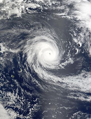
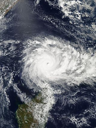
With an upper-level high located near the cyclone, the tropical cyclone steadily became better organized and thus Connie began to strengthen rapidly, [2] as previously indicated by many tropical cyclone forecast models. The system then began to slowly turn southeast in the general direction of Mauritius and Réunion. [1] By 1800 UTC on January 27, Tropical Cyclone Connie developed a very well defined eye; [2] based on this, MFR upgraded Connie to a very intense tropical cyclone. [1] Around this time, the JTWC raised the intensity of Connie to 215 km/h (135 mph), equal to a borderline Category 4 hurricane on the SSHWS, based on Dvorak intensity estimates of T5.5 and T6.0. [2] After passing around 500 km (310 mi) north-northwest of Mauritius, Connie then decelerated east-southeast. [1] At 0000 UTC on January 28, MFR estimated that Connie attained its peak intensity of 185 km/h (115 mph). Despite this cloud tops associated with Connie began to warm, even though the eye remained well-defined. Thus, the JTWC lowered the intensity of Connie to 190 km/h (120 mph), based on a blend of satellite intensity estimates. [2]
Early on January 28, Connie made its closest approach to St. Brandon and initially appeared to be approaching Mauritius. However, many computer models correctly predicted Connie to turn southwest and threaten Reunion. Throughout the day, Connie maintained its intensity, but by the evening on January 28, thunderstorm activity diminished and the cloud structure became less organized, [1] though the storm maintained a small eye. Increased southerly wind shear from a tropical upper tropospheric trough (TUTT) took toll on the system. During the morning hours of January 29 both agencies reduced the intensity to 145 km/h (90 mph) as the storm began to encounter dry air. [2] By the afternoon, MFR downgraded Connie to tropical cyclone status; the eye had become cloud-filled, although it was still visible on radar. That night, the storm passed 130 km (80 mi) northwest of Reunion. Early on January 30, MFR downgraded Connie to a severe tropical storm. [1] Later that day, the JTWC estimated that Connie lost hurricane-force winds roughly 500 km (310 mi) east of the southern tip of Madagascar; all of the storm's deep convection by this time was displaced to the south. [2]
After moving away from Reunion, Connie accelerated towards the south around a subtropical ridge situated near Amsterdam Island. [1] On January 31, Connie turned southeast, steered about a trough to the southeast. [2] Contrary to forecasts which predicted continued weakening, MFR kept the intensity at 105 km/h (65 mph) for most of January 31. Based on satellite derived intensity estimates, the JTWC briefly re-upgraded Connie to a Category 1 hurricane equivalent on the SSHWS at 1800 UTC. However, the re-strengthening trend was short lived [2] due to increased northwesterly wind shear. [1] Satellite imagery early on February 1 revealed an exposed circulation and a rapid decreased of thunderstorm activity in bothy coverage and intensity. Based on this and the fact that the storm appeared to be losing tropical characteristics, MFR issued its final advisory on Connie. However, the JTWC continued to track Connie until February 2, [2] when it merged with an extratropical low. [1] At the time of dissipation, the JTWC assessed the intensity of Connie at 50 km/h (30 mph). [2]
Impact
Despite large uncertainty in the storm's path, the international airport on the eastern side of Mauritius and all ships within the Port Louis harbor had departed. [6] A cyclone warning was declared and 165 shelters were opened. As a precaution, power was turned off. However, on the afternoon of January 29 all sea and airports were re-opened and power was turned back on as the storm moved away. [7]
While making its closet approach to Mauritius on January 28, Connie brought heavy rains and strong winds to the archipelago. Winds greater than 100 km/h (62 mph) were recorded through much of the island, including a peak of 134 km/h (83 mph) in Médine. During a six-day period from January 26 to January 31, many locations along the eastern portion of the island received 600 mm (25 in), equivalent to approximately a month's worth of rainfall, including a maximum rainfall of 647 mm (25.5 in). These rains helped relieve extreme drought conditions. Offshore, waves up to 7.95 m (26.1 ft) in height were reported. [1] One man perished on his roof while trying to fix his antenna. [8] Two rivers were flooded but all in all, damage was minimal. [7]
Due to its slow motion, Intense Tropical cyclone Connie deluged Reunion with heavy rains for several days before suddenly tampering off on January 29. Throughout the passage of the cyclone, many locations recorded wind gusts in excess of 100 km/h (62 mph), highlighted by 133 km/h (83 mph) in Le Port, 155 km/h (95 mph) in Peite France, and 216 km/h (134 mph) in Maida. Moreover, a peak rainfall total of 1,752 mm (69.0 in) was measured in Commerson, 1,296 mm (51.0 in) of which occurred in a 24-hour time frame. Many roads across Reunion were damaged. Power was knocked out to 40,000 customers [1] while more than 100 homes were demolished. [9] Two persons were killed, [10] including a young man that fell while trying to observe the cyclone. [11] A total of 600 people were reported homeless; [8] roughly 300 people were evacuated. [12] Although the agriculture sector suffered the most significant damages, overall, damage was minor. [1] However, the French government later provided relief aid to Reunion as a result of the damage. [8]
The non-tropical remnants of Connie brought flooding to Southern Africa for several days. In Maputo, 328 mm (12.9 in) of rain fell within a day. Large sections of many neighborhoods were inundated. Roughly 20,000 people were rendered homeless. The road that linked Maputo to South Africa was cut. The Ministry of Education was forced to delay the start of the school year. Following the floods, roughly 20 emergency shelters were opened. These rains help set the stage for additional flooding caused by Cyclone Leon–Eline and Cyclone Hudah. [13]
See also
- Tropical cyclones in 2000
- Tropical cyclones in the Mascarene Islands
- Cyclone Dina (2002) – a tropical cyclone which had a similar track to Connie.
Notes
- ↑ The Météo-France office in Réunion is the official Regional Specialized Meteorological Center for the basin. [3]
- ↑ Wind estimates from MFR and most other basins throughout the world are sustained over 10 minutes, while estimates from the United States-based Joint Typhoon Warning Center are sustained over 1 minute. 10 minute winds are about 1.14 times the amount of 1 minute winds. [4]
Related Research Articles

The 1999–2000 South-West Indian Ocean tropical cyclone season was the first on record in which two storms – Leon–Eline and Hudah – struck Mozambique at tropical cyclone intensity, or with maximum sustained winds of at least 120 km/h (75 mph). The most notable storm of the season was Eline, which was the third longest-lasting storm on record in the basin. It lasted for 29 days while traversing the southern Indian Ocean, making the strongest landfall in decades along eastern Madagascar in late February. The storm was the first in a series of three storms that struck the country in early 2000, along with Gloria in March and Hudah in April. Collectively, the three storms killed at least 316 people. The season started on November 1, 1999, and ended for most of the basin on April 30, 2000; for Mauritius and the Seychelles, the season continued until May 15. These dates conventionally delimit the period of each year when most tropical cyclones form in the basin.

The 2006–07 South-West Indian Ocean cyclone season featured the second-most intense tropical cyclones for a season in the tropical cyclone basin, only behind the 2018–19 season. The basin contains the waters of the Indian Ocean south of the equator and west of 90°E. Météo-France's meteorological office in Réunion (MFR), the official Regional Specialized Meteorological Center for the South-West Indian Ocean, tracked 15 tropical disturbances, of which eleven attained gale-force winds. The season began in October 2006 with a short-lived tropical disturbance, followed by Anita in November, which was the first named storm of the season. Cyclone Bondo was the first of six intense tropical cyclones, which took a rare track through the southern Seychelles before making landfall on northwest Madagascar, killing 11 people. Severe Tropical Storm Clovis lasted from December 2006 to January 2007; it struck eastern Madagascar, killing four people.

The 2005–06 South-West Indian Ocean cyclone season was the fifth least-active on record. The Météo-France office on the island of Réunion tracked 13 tropical disturbances, of which six intensified into a moderate tropical storm. Three of these systems proceeded to attain tropical cyclone status – reaching 10 minute maximum sustained winds of at least 120 km/h (75 mph). The American-based Joint Typhoon Warning Center also tracked eight storms in the basin. Activity was below normal due to a powerful Walker circulation, which increased convection over the neighboring Australian basin, but suppressed activity in the western Indian Ocean. As a result, most of the storms developed near or entered from the Australian basin, crossing 90°E to enter the South-West Indian Ocean.
The 2004–05 South-West Indian Ocean cyclone season was a near average season, despite beginning unusually early on August 30 with the formation of an early-season tropical depression. Météo-France's meteorological office in Réunion (MFR) ultimately monitored 18 tropical disturbances during the season, of which 15 became tropical depressions. Two storms – Arola and Bento – formed in November, and the latter became the most intense November cyclone on record. Bento attained its peak intensity at a low latitude, and weakened before threatening land. Tropical Cyclone Chambo was the only named storm in December. In January, Severe Tropical Storm Daren and Cyclone Ernest existed simultaneously. The latter storm struck southern Madagascar, and five days later, Moderate Tropical Storm Felapi affected the same area; the two storms killed 78 people and left over 32,000 people homeless. At the end of January, Severe Tropical Storm Gerard existed as an unnamed tropical storm for 18 hours due to discrepancies between warning centers.
The 2003–04 South-West Indian Ocean cyclone season featured the most intense tropical cyclone in the South-West Indian Ocean, Cyclone Gafilo, as well as nine other named storms. Tropical activity began on September 28 when Moderate Tropical Storm Abaimba formed at a low latitude. Activity continued until late May, following Severe Tropical Storm Juba, which marked the third year in a row that a storm formed in May. The final disturbance, one of sixteen, dissipated on May 24. Activity was near average, and the season was one of the longest on record.

The 2002–03 South-West Indian Ocean cyclone season was one of the longest lasting and the third-most active season in the South-West Indian Ocean. Storms during the season impacted the Mascarene Islands, Seychelles, Madagascar, and countries in south-eastern Africa. The season began early when an unnamed tropical storm struck Seychelles in September, becoming the most damaging storm there in 50 years. The next system, Atang, was the first named storm of the season, but was only a tropical depression; it was named due to the threat to an outer island of Mauritius. Atang later struck Tanzania in a climatologically unusual area in November, resulting in unconfirmed deaths of fishermen. The first named storm to reach tropical storm intensity was Boura, which brushed the Mascarene Islands with gusty winds and rainfall. In December, Cyclone Crystal threatened to strike Mauritius but instead veered eastward, and later, Tropical Storm Delfina lasted from late December through early January 2003. Delfina damaged or destroyed thousands of houses in Mozambique and Malawi, killing 54 people.
The 2001–02 South-West Indian Ocean cyclone season had the earliest named storm since 1992. Many storms formed in the north-east portion of the basin, and several more originated around Australia. The basin is defined as the waters of the Indian Ocean west of longitude 90°E to the coast of Africa and south of the equator. Eleven tropical storms formed, compared to an average of nine. Tropical systems were present during 73 days, which was significantly higher than the average of 58 for this basin.
The 2000–01 South-West Indian Ocean cyclone season was a fairly quiet season with only five named storms, although there was an additional unnamed tropical storm and two subtropical cyclones with gale-force winds. It started early, with a tropical disturbance forming on August 1 – the first day of the cyclone year. However, the first named storm, Ando, was not named until January 2, which at the time was the 4th latest on record. Ando would become the most intense cyclone of the year, reaching peak winds of 195 km/h (121 mph) according to the Météo-France office (MFR) on Réunion, the official Regional Specialized Meteorological Center for the basin. The agency tracked storms south of the equator and west of 90°E to the east coast of Africa.

The 2008–09 South-West Indian Ocean cyclone season was a slightly above average event in tropical cyclone formation. It began on November 15, 2008, and officially ended on April 30, 2009, with the exception for Mauritius and the Seychelles, for which it ended on May 15, 2009. These dates conventionally delimit the period of each year when most tropical cyclones form in the basin, which is west of 90°E and south of the Equator. Tropical cyclones in this basin were monitored by the Regional Specialised Meteorological Centre in Réunion.

Intense Tropical Cyclone Kalunde was the strongest storm of the 2002–03 South-West Indian Ocean cyclone season. The eleventh named storm and sixth cyclone of the season, Kalunde formed on March 4 from an area of disturbed weather east-southeast of Diego Garcia. The storm steadily strengthened and attained severe tropical storm intensity on March 6. After starting a phase of rapid deepening, Kalunde attained cyclone intensity the next day. Kalunde attained its peak intensity on March 8, as an intense tropical cyclone. It maintained its peak strength for a day; shortly thereafter, the system began to weaken. After undergoing an eyewall replacement cycle, the storm brushed Rodrigues. Shortly after doing so, Kalunde weakened into a tropical cyclone and later a severe tropical storm. Two days later, on March 16, the cyclone transitioned into an extratropical cyclone and dissipated the next day.
The 1992–93 South-West Indian Ocean cyclone season lasted longer than normal, with the first storm Aviona forming on September 27 and the final storm Konita not dissipating until May 7. It was an above-average season, with four tropical cyclones – the equivalent of a minimal hurricane – along with six tropical storms, one subtropical depression, and several depressions including one that was named. The basin is defined as the area west of 90°E and south of the Equator in the Indian Ocean, which includes the waters around Madagascar westward to the east coast of Africa. Tropical cyclones in this basin are monitored by the Regional Specialised Meteorological Centre in Réunion (MFR), as well as by the Joint Typhoon Warning Center (JTWC).

The 1984–85 South-West Indian Ocean cyclone season was an average cyclone season. Tropical cyclones in this basin are monitored by the Regional Specialised Meteorological Centre in Réunion. The first storm formed in mid-November, though it was not officially named. A few days later, the first official storm of the year (Anety) formed. In December, one storm formed. During January 1985, two tropical cyclones formed towards the end of the month. Three more systems developed in a short period of time in early to mid-February. After nearly two more months of inactivity, an unusually powerful late season storm developed (Helisaonina) in mid-April, which was the strongest storm of the year. While a number of storms during the season reached severe tropical storm status, only one of those intensified further. Even though two tropical cyclones this year made landfall, no known damage was recorded.

The 1993–94 South-West Indian Ocean cyclone season was the most active season in the basin since the start of reliable satellite coverage in 1967, until the record was surpassed 25 years later in the 2018–19 South-West Indian Ocean cyclone season. Activity lasted from mid-November, when Moderate Tropical Storm Alexina formed, until mid-April, when Tropical Cyclone Odille became extratropical. Four tropical cyclones – Daisy, Geralda, Litanne, and Nadia – struck eastern Madagascar, of which Geralda was the costliest and deadliest. With gusts as strong as 350 km/h (215 mph) accompanied by heavy rainfall, Geralda destroyed more than 40,000 homes and left 356,000 people homeless. Geralda killed 231 people and caused more than $10 million in damage. Cyclone Nadia was the second deadliest cyclone, having killed 12 people in northern Madagascar and later severely damaging portions of northeastern Mozambique, killing about 240 people and leaving $20 million in damage in the latter country. In February, Cyclone Hollanda struck Mauritius near peak intensity, causing $135 million in damage and two deaths.
The 2012–13 South-West Indian Ocean cyclone season was a slightly above average event in tropical cyclone formation in the Southern hemisphere tropical cyclone year starting on July 1, 2012, and ending on June 30, 2013. Within this basin, tropical and subtropical disturbances are officially monitored by the Regional Specialised Meteorological Centre on Réunion island, while the Mauritius and Madagascar weather services assign names to significant tropical and subtropical disturbances. The first tropical disturbance of the season developed on October 12 and rapidly developed into the earliest known intense tropical cyclone on record during October 14.
Intense Tropical Cyclone Dina was a cyclone that caused record flooding across parts of Réunion. Originating from a tropical disturbance on 15 January 2002 near the Chagos Archipelago, the precursor to Dina quickly developed within a region favoring tropical cyclogenesis. By January 17, the system had developed enough organized convection as it moved southwestward to be declared a tropical depression. Rapid intensification occurred shortly thereafter, with the system attaining winds in excess of 120 km/h (75 mph) on January 18. Dina achieved its peak intensity on January 20 as an intense tropical cyclone with maximum sustained winds of 215 km/h (135 mph). Hours after reaching hits strength, the storm bypassed Rodrigues Island about 150 km (95 mi) to its north. On January 21, the storm brushed Mauritius and Réunion as an intense tropical cyclone before turning southward. Once on a southward course, steady weakening ensued and the system eventually transitioned into an extratropical cyclone on January 25. The remnants of the storm accelerated southeastward and were last noted on January 28 before being absorbed into a polar trough.

Very Intense Tropical Cyclone Hary was the strongest tropical cyclone in the 2001–02 South-West Indian Ocean cyclone season. Developing on March 5 from the monsoon trough, the storm initially moved generally to the west and gradually intensified. With favorable conditions, Hary quickly intensified on March 7, developing an eye and well-defined outflow. After reaching an initial peak, the cyclone briefly weakened due to an eyewall replacement cycle, by which time the storm turned southwestward toward Madagascar. Hary re-intensified and attained peak winds of 220 km/h (140 mph) on March 10 just offshore eastern Madagascar, which made it the first very intense tropical cyclone since 2000.
The 2014–15 South-West Indian Ocean cyclone season was an above average event in tropical cyclone formation. It began on November 15, 2014, and ended on April 30, 2015, with the exception for Mauritius and the Seychelles, for which it ended on May 15, 2015. These dates conventionally delimit the period of each year when most tropical and subtropical cyclones form in the basin, which is west of 90°E and south of the Equator. Tropical and subtropical cyclones in this basin are monitored by the Regional Specialised Meteorological Centre in Réunion.

Intense Tropical Cyclone Favio was the first known tropical cyclone that passed south of Madagascar to strike Africa as an intense tropical cyclone. Early on 11 February 2007, a zone of disturbed weather formed east of Madagascar. Four days later, Favio was named as intensified to a moderate tropical storm while moving southwest. On 18 February, the storm was upgraded into a severe tropical storm. Then, it turned west in the general direction of Mozambique. Continuing to intensify, Favio was upgraded to a tropical cyclone early on 19 February. Subsequently, the storm began to undergo rapid deepening; the small storm reached intense tropical cyclone status the next day before peaking in intensity. However, the cyclone had weakened somewhat prior to making landfall on 22 February in the Inhambane Province in Mozambique. It rapidly weakened over land and dissipated the next day.

Tropical Storm Clotilda was a destructive tropical cyclone that inundated Réunion in February 1987. A tropical disturbance first formed between Madagascar and Réunion on February 9 and slowly intensified thereafter. While meandering, the storm fluctuated in intensity before it reached its peak intensity on February 13, with winds of 110 km/h (70 mph). After passing near Réunion, it began to weaken. On February 16, however, Clotilda began to regain strength, and reached its secondary peak on February 17. Two days later, Clotilda became an extratropical cyclone. By February 22, Clotilda was no long being tracked by meteorologists. While active, it brought torrential rains to the island of Réunion during a span of 72 hours. A total of 1,855 mm (73.0 in) of rain was recorded in La Plaine-des-Palmistes; rainfall totals occasionally exceeded the totals measured during Cyclone Hyacinthe, the last major storm to affect Réunion. However, the peak total measured in Hyacinthe was lower than the total measured during Clotilda. Furthermore, about 250 homes were damaged and roughly 120 homes were destroyed. Eighty-nine trees were also brought down during the storm. Throughout the island, damage totaled $2 million (1987 USD) and 10 people were killed. In addition to the destruction on Réunion, 5% of crops on Mauritius were impacted by the storm. During the aftermath of the cyclone, 1,000 people on Réunion were evacuated to shelters.
Very Intense Tropical Cyclone Fantala was the most intense tropical cyclone recorded in the South-West Indian Ocean in terms of sustained winds. Part of the 2015–16 cyclone season, Fantala formed on 11 April to the south of Diego Garcia, an island in the central Indian Ocean. With a ridge to the south, the storm moved westward for several days while gaining strength, aided by warm waters and decreasing wind shear. Late on 17 April, the Météo-France office on Réunion (MFR) estimated peak 10-minute winds of 250 km/h (155 mph), making Fantala the strongest tropical cyclone of the basin in terms of 10-minute sustained winds. The Joint Typhoon Warning Center (JTWC) estimated peak 1-minute winds of 285 km/h (180 mph), equivalent to Category 5 intensity on the Saffir-Simpson scale, also the strongest on record in the South-West Indian Ocean, in terms of maximum sustained wind speed. Early on 18 April, Fantala reached its peak intensity, with a minimum central pressure of 910 millibars (27 inHg).
References
- 1 2 3 4 5 6 7 8 9 10 11 12 13 14 15 Cyclone Season 1999–2000. RSMC La Reunion (Report). Meteo-France. Retrieved July 18, 2014.
- 1 2 3 4 5 6 7 8 9 10 11 12 13 14 15 Monthly Global Tropical Cyclone Summary January 2000 (Report). Retrieved July 18, 2014.
- ↑ Worldwide Tropical Cyclone Centers (Report). National Hurricane Center. November 9, 2011. Retrieved July 18, 2014.
- ↑ Christopher W Landsea; Hurricane Research Division (April 26, 2004). "Subject: D4) What does "maximum sustained wind" mean? How does it relate to gusts in tropical cyclones?". Frequently Asked Questions. National Oceanic and Atmospheric Administration's Atlantic Oceanographic and Meteorological Laboratory. Retrieved July 18, 2014.
- ↑ Kenneth R. Knapp; Michael C. Kruk; David H. Levinson; Howard J. Diamond; Charles J. Neumann (2010). 2000 CONNIE (2000025S15056). The International Best Track Archive for Climate Stewardship (IBTrACS): Unifying tropical cyclone best track data (Report). Bulletin of the American Meteorological Society. Archived from the original on October 2, 2015. Retrieved July 18, 2014.
- ↑ "State radio reports that Cyclone Connie headed for Mauritius". Associated Press. January 28, 2000.
- 1 2 "Cyclone misses Mauritius, causes heavy rains and winds". Associated Press. January 29, 2000.
- 1 2 3 "Cyclone kills two, destroys hundreds of homes on island". Associated Press. January 30, 2000.
- ↑ "Indian Ocean cyclone". Pittsburgh Post Gazette. February 4, 2000. p. 8. Retrieved June 21, 2013.
- ↑ "Island Cyclone Kills Two". AP News Archive. Associated Press. January 30, 2000. Retrieved July 20, 2014.
- ↑ "La Réunion échappe au cyclone Connie". Liberation Societe (in French). January 31, 2000. Retrieved July 20, 2014.
- ↑ "Cyclone Connie hits". The Gazette. January 30, 2000.
- ↑ Frances Christie and Joseph Halon (2001). Mozambique & the Great Flood of 2000. Indianan University Press. ISBN 0253339782.
 Cyclone Connie on January 28 |
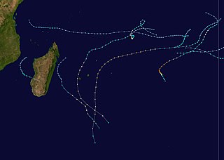
Tropical cyclones of the 1999–2000 South-West Indian Ocean cyclone season | ||
|---|---|---|
 | ||