Dawson, South Australia

Last updated

Dawson
South Australia
Australia South Australia location map.svg
Red pog.svg
Dawson
Coordinates 32°48′14″S138°58′30″E / 32.804°S 138.975°E / -32.804; 138.975 Coordinates: 32°48′14″S138°58′30″E / 32.804°S 138.975°E / -32.804; 138.975
Population3 (2016 census) [1]
Established19 May 1881 (town)
31 August 2000 (locality) [2]
Postcode(s) 5720 [2]
Location25 km (16 mi) NE of Peterborough
LGA(s) District Council of Peterborough
Region Yorke and Mid North [2]
County Herbert [2]
State electorate(s) Stuart [2]
Federal division(s) Grey [2]
Localities around Dawson:
Erskine Cavenagh Paratoo
Erskine
Minvalara
Dawson Nackara
Minvalara Ucolta Parnaroo
Oodla Wirra
FootnotesAdjoining localities [2]

Dawson is a rural locality in the Mid North region of South Australia, situated in the District Council of Peterborough. It covers the entirety of the cadastral Hundred of Coglin, with the exception of the small town of Oodla Wirra. [2]

Contents

Boundaries for the locality were created on 31 August 2000 and it was given the "long established name" of Dawson which is derived from the Government Town of Dawson whose site is located within the boundaries of the locality. [2]

History

The government town of Dawson was surveyed in February 1881; it was often referred to as Coglin in its early years. It was founded as part of an attempt to establish wheat farming north of Goyder's Line, but this proved unsuccessful in the long term, and the Crystal Brook-Broken Hill railway line bypassed Dawson, instead running further south through Oodla Wirra and Peterborough. Coglin Post Office opened in 1881, was renamed Dawson Post Office in April 1882, and closed on 14 August 1971. [3] [4] [5]

The 1880s saw the construction of Primitive Methodist, Anglican and Catholic churches; the former Our Lady of Mount Carmel Catholic Church (1886) survives and is listed on the South Australian Heritage Register. [6] The Dawson Hotel was built in 1883. [7] A public school opened in 1885 after several years of agitation from local residents. [4] [8] [9] Local government came to the area in 1888 with the District Council of Coglin; it met alternately at Dawson and Lancelot until 1899, when the council seat shifted to Penn (now Oodla Wirra). [10] At its peak, Dawson also had multiple stores, churches, an institute, [11] an agricultural bureau, and a blacksmith. [4] Information on a proposed school appeared in 1883; Dawson School, opened in 1885, closed in 1964.

The town had a football team, in the 20th century. [12]

In 1949, it was suggested that all unsold allotments be purchased by the government and, by 1960, this had been accomplished and the town was diminished. Its post office, opened as 'Coglin' in January 1881, closed on 14 August 1971. [13]

In 1954 the government began to resume town blocks if they had never been purchased or if the owners were not traceable. In 1960 the town was officially abolished as a town.[ according to whom? ]

Very little of the former town survives today. It contains the heritage-listed former Catholic church, the Dawson Hall, and the former school, now a private residence. The Dawson Cemetery on Dawson Gorge Road and Dawson War Memorial on Dawson-Peterborough Road also remain. [14] [15] The Dawson Hotel closed in 1961, and survives as a substantial ruin at Dawson's main crossroads. [16]

Name

It has been conjectured that the name derives from one of several people: [13]

Related Research Articles

<span class="mw-page-title-main">Clermont, Queensland</span> Town in Queensland, Australia

Clermont is a rural town and locality in the Isaac Region, Queensland, Australia. At the 2021 census, the locality of Clermont had a population of 2952 people.

<span class="mw-page-title-main">Peterborough, South Australia</span> Town in South Australia

Peterborough is a town in the mid north of South Australia, in wheat country, just off the Barrier Highway. At the 2016 census, Peterborough had a population of 1,419. It was originally named Petersburg after the landowner, Peter Doecke, who sold land to create the town. It was one of 69 places in South Australia renamed in 1917 due to anti-German sentiments during World War I.

<span class="mw-page-title-main">District Council of Peterborough</span> Local government area in South Australia

The District Council of Peterborough is a local government area in the Yorke and Mid North region of South Australia. The principal town and council seat is Peterborough; it also includes the localities of Cavenagh, Dawson, Hardy, Minvalara, Nackara, Oodla Wirra, Paratoo, Parnaroo, Sunnybrae, Ucolta and Yongala.

<span class="mw-page-title-main">Mount Larcom, Queensland</span> Town in Queensland, Australia

Mount Larcom is the name of a mountain, a rural town and locality in the Gladstone Region, Queensland, Australia. In the 2016 census, the locality of Mount Larcom had a population of 361 people.

<span class="mw-page-title-main">Baralaba, Queensland</span> Town in Queensland, Australia

Baralaba is a rural town and locality in the Shire of Banana in central Queensland, Australia. In the 2016 census, Baralaba had a population of 314 people.

<span class="mw-page-title-main">Carrieton</span> Town in South Australia

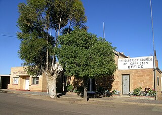
Carrieton is a small town situated in the Flinders Ranges of South Australia. It is located between the towns of Orroroo to the south and Cradock to the north.

<span class="mw-page-title-main">Black Rock, South Australia</span> Town in South Australia

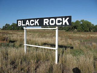
Black Rock is a hamlet in South Australia on the Black Rock Plains at the intersection of the south–north RM Williams Way (B80) between Jamestown and Orroroo and the west–east Wilmington–Ucolta Road (B56) to Peterborough, in the Mid North section of the state.

<span class="mw-page-title-main">Einasleigh, Queensland</span> Town in Queensland, Australia

Einasleigh is a town and a locality in the Shire of Etheridge, Queensland, Australia. In the 2016 census, the locality of Einasleigh had a population of 92 people.

<span class="mw-page-title-main">Parnaroo, South Australia</span> Town in South Australia

Parnaroo is a rural locality in South Australia, situated east of Peterborough. It shares the same boundaries as the cadastral Hundred of Parnaroo, which was established on 31 October 1878. It was reportedly named for an Aboriginal word meaning "rain of little stones", which had been taken from a sheep run opened in the area in 1854. The modern locality was formalised in August 2000, and named for the long established local name.

Hammond is a town and locality in the Australian state of South Australia located in the southern Flinders Ranges.

Belton is a rural locality in South Australia, located in the District Council of Orroroo Carrieton. It is traversed by the Carrieton-Barata Road, the Carrieton-Belton Road and the Weira Creek. The locality was established on 26 April 2013 in respect to “the long established local name.”

<span class="mw-page-title-main">District Council of Coglin</span>

The District Council of Coglin was a local government area in South Australia. It came into operation on 5 January 1888 under the provisions of the District Councils Act 1887. At its inception, it comprised the Hundreds of Cavenagh, Coglin, Gumbowie, Parnaroo, Hardy, Nackara, and Paratoo. It was divided into four wards: Coglin, Gumbowie, East and North. Meetings were held alternately at Dawson and Lancelot until 1899, and thereafter at Penn.

The District Council of Yongala was a local government area in South Australia from 1883 to 1935, seated at Yongala.

<span class="mw-page-title-main">Corporate Town of Peterborough</span>

The Corporate Town of Peterborough was a local government area in South Australia centred on the town of Peterborough. It came into existence on 7 October 1886 when it separated from the surrounding District Council of Yongala. It was initially known as Petersburg; it was renamed Peterborough on 10 January 1918, one of many South Australian places to be renamed as a consequence of World War I. It gained additional sections from the Yongala council on 30 August 1888 and 25 November 1897, but lost some territory in 1935 when Yongala amalgamated with the adjacent District Council of Coglin to create the District Council of Peterborough. The two municipalities would coexist alongside each other, the town surrounded by the district council, for more than sixty years.

<span class="mw-page-title-main">Oodla Wirra, South Australia</span> Town in South Australia

Oodla Wirra is a small town in the upper Mid North of South Australia. It is on the Barrier Highway approximately halfway from Adelaide to Broken Hill.

Mannanarie is a rural locality in the Mid North region of South Australia, situated in the Northern Areas Council. It was established in April 2001, when boundaries were formalised for the "long established local name". It comprises most of the cadastral Hundred of Mannanarie, apart from a northern section which lies in Tarcowie and Yatina. The name stems from an Aboriginal word, "manangari", meaning "good string or cord", stemming from a local native plant useful for string making.

Custon is a locality in the Australian state of South Australia located in the state's south-east within the Limestone Coast region about 267 kilometres south east of the state capital of Adelaide, about 19.5 kilometres south-east of the municipal seat of Bordertown and adjoining the border with the State of Victoria.

<span class="mw-page-title-main">Hundred of Coglin</span>

The Hundred of Coglin is a hundred within the County of Herbert, South Australia and proclaimed in 1878.

<span class="mw-page-title-main">County of Herbert</span> Cadastral in South Australia

County of Herbert is a cadastral unit located in the Australian state of South Australia that covers land to the east of the Flinders Ranges about 55 kilometres (34 mi) north-east of the town of Peterborough. It was proclaimed in 1877 and named after a prominent man of the time with either a title or a surname containing the name ‘Herbert’. It has been partially divided in the following sub-units of hundreds – Cavenagh, Coglin, Minburra, Nackara, Paratoo and Waroonee.

<span class="mw-page-title-main">County of Kimberley</span> Cadastral in South Australia

County of Kimberley is a cadastral unit located in the Australian state of South Australia that covers land to the east of the Flinders Ranges about 45 kilometres (28 mi) east of the town of Peterborough. It was proclaimed in 1871 and named after John Wodehouse, 1st Earl of Kimberley, a British Secretary of State for the Colonies. It has been partially divided in the following sub-units of hundreds – Gumbowie, Hardy, Ketchowla, Parnaroo, Terowie and Wonna.

References

  1. Australian Bureau of Statistics (27 June 2017). "Dawson (State Suburb)". 2016 Census QuickStats. Retrieved 7 February 2018. OOjs UI icon edit-ltr-progressive.svg
  2. 1 2 3 4 5 6 7 8 9 "Search result(s) for 'Dawson, 5422' with the following datasets selected - 'Suburbs and localities', 'Government Towns', 'Counties', 'SA Government Regions', 'Local Government Areas' and 'Gazetteeer'". Location SA Map Viewer. Government of South Australia. Retrieved 16 February 2016.
  3. "Search result(s) for Dawson, 5422". Property Location Browser. Government of South Australia. Archived from the original on 12 October 2016. Retrieved 17 February 2016.
  4. 1 2 3 "Dawson". South Australian History. Retrieved 19 March 2016.
  5. "Dawson". Post Office Reference. Premier Postal. Retrieved 19 March 2016.
  6. "Former Our Lady of Mount Carmel Catholic Church". South Australian Heritage Register. Department of Environment, Water and Natural Resources. Retrieved 19 March 2016.
  7. "Advertising". South Australian Register . Vol. XLVIII, no. 11, 442. South Australia. 17 July 1883. p. 7. Retrieved 19 March 2016 via National Library of Australia.
  8. "ANGAS V. COWAN AND OTHERS". South Australian Register . Vol. XLVIII, no. 11, 485. South Australia. 5 September 1883. p. 4. Retrieved 19 March 2016 via National Library of Australia.
  9. "GENERAL NEWS". The Express and Telegraph . Vol. XX, no. 5, 910. South Australia. 18 September 1883. p. 2 (SECOND EDITION). Retrieved 19 March 2016 via National Library of Australia.
  10. Marsden, Susan (2012). "A History of South Australian Councils to 1936" (PDF). Local Government Association of South Australia. p. 41.
  11. Mechanics Institute of Dawson, South Australia.
  12. the Chronicle newspaper, 31 October 1935, page 36.
  13. 1 2 South Australian Names.
  14. "Dawson Cemetery". District Council of Peterborough. Retrieved 19 March 2016.
  15. "Dawson War Memorial" . Retrieved 19 March 2016.
  16. "Ruins of the Dawson Hotel [B 55509] • Photograph". State Library of South Australia. Retrieved 19 March 2016.