
Chestnut Hill is a wealthy New England village located six miles (10 km) west of downtown Boston, Massachusetts, United States. It is best known for being home to Boston College and a section of the Boston Marathon route. Like all Massachusetts villages, Chestnut Hill is not an incorporated municipal entity. It is located partially in Brookline in Norfolk County; partially in the city of Boston in Suffolk County, and partially in the city of Newton in Middlesex County. Chestnut Hill's borders are defined by the 02467 ZIP Code. The name refers to several small hills that overlook the 135-acre Chestnut Hill Reservoir rather than one particular hill.

The West Newton Hill NR Historic District is a residential National Register historic district in the village of West Newton, in the city of Newton, Massachusetts in the United States. It is composed of a cohesive collection of spacious houses built in the second half of the 19th century, representing the development of the West Newton area as a fashionable railroad suburb. The district was listed on the National Register of Historic Places in 1986.
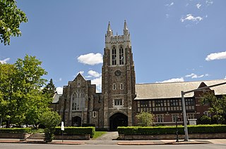
The First Unitarian Universalist Society in Newton occupies a prominent location at 1326 Washington Street in the heart of the village of West Newton in Newton, Massachusetts. Architect Ralph Adams Cram designed the church, Frederick Law Olmsted Jr. designed the grounds, the cornerstone was laid in 1905, and it was dedicated in 1906; it is one of the village's oldest buildings. The church is in Cram's signature Gothic Revival style, with buttressed walls and a blocky square tower with crenellations and spires. An enclosed courtyard is formed by an office wing, banquet hall, and parish house, which are built to resemble Elizabethan architecture with brick first floor and half-timbered upper level.

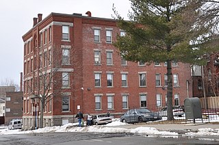
The Chestnut Hill is a historic apartment building at 219 Commonwealth Avenue in the village of Chestnut Hill in Newton, Massachusetts, USA.

The Chestnut Hill Reservoir Historic District is a historic district encompassing the Chestnut Hill Reservoir and the surrounding water works facilities which were historically used to provide fresh water to Boston, Massachusetts, and surrounding towns. The district is nearly coextensive with the Chestnut Hill Reservation, a state park managed by the Massachusetts Department of Conservation and Recreation (DCR); those elements of the water works that are still required as an emergency backup are managed by the Massachusetts Water Resources Authority (MWRA). The reservoir is located between Beacon Street and Commonwealth Avenue in Boston's Chestnut Hill district, just east of the Boston College Main Campus Historic District.

The Newtonville Historic District is a historic district in the village of Newtonville, in Newton, Massachusetts. The district encompasses the southern portion of the village's business district, as well as surrounding residential areas. It was listed on the National Register of Historic Places in 1986, and enlarged in 1990.

The Everett Avenue–Sheffield Road Historic District is a historic district encompassing one of the finest residential districts from the turn of the 20th century in Winchester, Massachusetts. The district is roughly triangular in shape, bounded in the north by Bacon Street, on the west by Church Street, Sheffield West, and Sheffield Road, and on the south and heast by the Upper Mystic Lake and Mystic Valley Parkway. It is characterized by winding roads, with relatively large houses on well-proportioned lots. Most of the houses were built between 1890 and 1916, and all exhibit some architectural sophistication. A significant number of properties were designed by either F. Patterson Smith or Dexter Blaikie, two local architects. The district was listed on the National Register of Historic Places in 1989.
The Wellington Street Apartment House District of Worcester, Massachusetts encompasses a collection of stylistically similar apartment houses in the city's Main South area. It includes sixteen properties along Jacques Avenue, and Wellington and Irving Streets, most of which were built between 1887 and 1901. The notable exception is the Harrington House at 62 Wellington Street, a c. 1850s Greek Revival house that was virtually the only house standing in the area before development began in the 1880s.

The Nobility Hill Historic District is a residential historic district roughly bounded by Chestnut and Maple Streets and Cedar Avenue in Stoneham, Massachusetts. The district includes a number of high quality houses representing a cross section of fashionable housing built between 1860 and 1920. It was added to the National Register of Historic Places in 1990.

The Commonwealth Avenue Historic District of Newton, Massachusetts, encompasses roughly the eastern half of Commonwealth Avenue, extending from Waban Hill Road, near the city line with Boston, westward to Walnut Street. The roadway was laid out in 1894 and completed in 1895. Its design was influenced in part by the local residents, who were willing to give land for some of the route, and the design of Boston portions of the road, in which Frederick Law Olmsted was involved. Construction of the roadway was followed by the construction of fashionably large residences along its route, which took place mostly between the road's construction and about 1920. The district includes 188 residential properties, which are mainly built in the revival styles popular in the early 20th century. The district was added to the National Register of Historic Places in 1990.
The Farlow Hill Historic District is a residential historic district in the Newton Corner area of Newton, Massachusetts, United States. It includes houses on Shornecliffe Road, Beechcroft Road, Farlow Road, Huntington Road, and a few properties on immediately adjacent streets. Most of the houses in the district were built between 1899 and the late 1920s and are either Craftsman or Colonial Revival in their style. The area was created by the subdivision of the estate of John Farlow, and includes 37 large and well-appointed houses, generally architect-designed, on ample lots. The district was listed on the National Register of Historic Places in 1990.

The Gray Cliff Historic District is a residential historic district encompassing a cluster of exceptionally high quality houses built in Newton, Massachusetts, between about 1890 and 1940. When first listed on the National Register of Historic Places in 1986, it included only the eight houses at 35, 39, 43, 53, 54, 64, 65, and 70 Gray Cliff Road, which were predominantly Shingle style house built before the turn of the 20th century. The district was expanded in 1990 to include an adjacent area known as The Ledges, where the houses were built between 1900 and 1940, and are mainly Colonial Revival and Tudor Revival in their styling.

The Monadnock Road Historic District is a residential historic district encompassing a cohesive subdivision of a former estate in the 1920s in the Chestnut Hill section of Newton, Massachusetts. The development was typical of Newton's explosive residential growth at that time, and includes primarily Tudor Revival houses. The district was listed on the National Register of Historic Places in 1990.

The Old Chestnut Hill Historic District encompasses the historic residential heart of the Newton portion of Chestnut Hill, Massachusetts. When first listed on the National Register of Historic Places in 1986, the district extended along Hammond Street, between Beacon Street and the MBTA Green Line right-of-way, and along Chestnut Hill Road between Hammond and Essex, including properties along a few adjacent streets. The district was expanded in 1990 to include more of Chestnut Hill Road and Essex Road, Suffolk Road and the roads between it and Hammond, and a small section south of the Green Line including properties on Hammond Street, Longwood Road, and Middlesex Road. A further expansion in 1999 added a single property on Suffolk Road.

The Pine Ridge Road–Plainfield Street Historic District encompasses a residential subdivision in the Waban section of Newton, Massachusetts. It includes 44 properties on Pine Ridge Road and Plainfield Street between Chestnut Street and Upland Road, and includes a few properties on the latter two streets. The area was laid out for development in the 1880s after the arrival of suburban rail service, and was built out by the 1930s. The district was listed on the National Register of Historic Places in 1990.

The Lewis Cabot Estate was a historic estate at Warren and Heath Streets in Brookline, Massachusetts. The estate, developed in 1894, was one of few surviving turn-of-the-century properties of the Boston Brahmin Cabot family, and a prominent local example of Jacobethan architecture with landscaping by Frederick Law Olmsted. The remnant portion of the estate was listed on the National Register of Historic Places in 1985; the main house has since been demolished.

The Fisher Hill Historic District encompasses a residential area in central Brookline, Massachusetts. The area was subdivided and built out beginning in the 1880s, with landscaping design by Frederick Law Olmsted and John Charles Olmsted. The district is bounded on the west by Chestnut Hill Avenue, Baxter Road, and Channing Road, and on the south by Massachusetts Route 9. Its eastern boundary runs along Buckminster Street to Dean Road, joining the northern boundary of Clinton Road, running between Dean Road and Chestnut Hill Avenue. Prior to its development in the 1880s, Fisher Hill had a relatively small number of landowners. Some of them banded together, hiring the Olmsteds to design a subdivision plan for the entire district. Lots were sold to wealthy individuals, who built fashionable houses, often designed by architects. In 1914 a restrictive covenant was entered into by a significant number of property owners, restricting their properties to strictly single-family residential uses.

Hartwell and Richardson was a Boston, Massachusetts architectural firm established in 1881, by Henry Walker Hartwell (1833–1919) and William Cummings Richardson (1854–1935). The firm contributed significantly to the current building stock and architecture of the greater Boston area. Many of its buildings are listed on the National Register of Historic Places.

The Eustis Estate is a historic family estate on Canton Avenue in Milton, Massachusetts. Its centerpiece is the mansion house of William Ellery Channing Eustis, an eclectic Late Victorian stone building designed by preeminent architect William Ralph Emerson and constructed in 1878. The estate also includes several other houses associated with the Eustis family, and a gatehouse and stable historically associated with the main estate. The estate was listed on the National Register of Historic Places as a historic district in 2016. Most of the original estate is owned by Historic New England, and was opened to the public as a museum property in 2017.
The Main Street and Murray Avenue Historic District of Worcester, Massachusetts encompasses a collection of stylistically similar apartment houses in the city's Piedmont neighborhood. It includes four properties, two each on Main Street and Murray Avenue, which form a cluster of apartment houses of a style that once lined both streets for greater length. The district was listed on the National Register of Historic Places in 2022.


