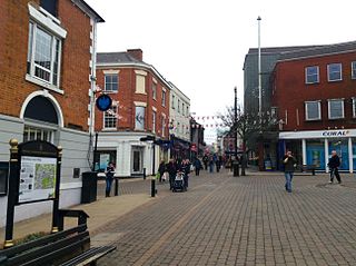
De Montfort, Hinckley

Last updated

De Montfort [1]
A447 Ashby Road in Hinckley - geograph.org.uk - 6477725.jpg
Hinckley-Upper Bond Street - geograph.org.uk - 3222708.jpg
Victorian house on Derby Road, Hinckley - geograph.org.uk - 5296144.jpg
Clockwise from top: Hinckley Ashby Road, Derby Road & Barwell Lane
Leicestershire UK location map.svg
Red pog.svg
De Montfort [4]
Location within Leicestershire
Population10,519 (2021 Census Ward Profile) [5]
  London 97 mi (156 km)  S
Civil parish
  • Unparished
District
Shire county
Region
Country England
Sovereign state United Kingdom
Post town Hinckley
Postcode district LE10
Dialling code 01455
Police Leicestershire
Fire Leicestershire
Ambulance East Midlands
UK Parliament
List of places
UK
England
Leicestershire
52°33′08″N1°21′57″W / 52.552336°N 1.365807°W / 52.552336; -1.365807

De Montfort is the name given to the ward [6] and suburb[ citation needed ] [7] [ failed verification ] of Hinckley in the Hinckley & Bosworth district in the county of Leicestershire, England. It is one of the six wards on Hinckley and Bosworth Borough Council of the town. [8]

Contents

Geography

The ward covers the eastern parts of Hinckley and is bounded by the A47/Normandy Way, Ashby Road and Barwell Lane. [9] It is predominantly residential, commercial, industrial and green spaces. [10]

Demographics

At the 2021 census, the ward profile population was 10,519. Of the findings, the ethnicity and religious composition of the ward was:

Hinckley De Montfort: Ethnicity: 2021 Census
Ethnic groupPopulation %
White9,97494.8%
Asian or Asian British2342.2%
Mixed1891.8%
Black or Black British630.6%
Other Ethnic Group560.5%
Arab30.1%
Total10,519100%

The religious composition of the ward at the 2021 Census was recorded as:

Hinckley De Montfort: Religion: 2021 Census
ReligiousPopulation %
Christian5,45754.3%
Irreligious4,31242.9%
Hindu880.9%
Muslim610.6%
Other religion500.5%
Sikh440.4%
Buddhist390.4%
Jewish40.1%
Total10,519100%

Related Research Articles

<span class="mw-page-title-main">Hinckley and Bosworth</span> Borough and non-metropolitan district in England

Hinckley and Bosworth is a local government district with borough status in Leicestershire, England. The council is based in Hinckley, the largest town. The borough also includes the town of Earl Shilton and numerous villages and surrounding rural areas. The Bosworth in the borough's name refers to the small market town of Market Bosworth, near which the Battle of Bosworth Field was fought in 1485.

<span class="mw-page-title-main">Hinckley and Bosworth (UK Parliament constituency)</span> Parliamentary constituency in the United Kingdom, 1885 onwards

Hinckley and Bosworth is a constituency represented in the House of Commons of the UK Parliament since 2019 by Luke Evans, a Conservative.

<span class="mw-page-title-main">Boney Hay & Central</span> Suburb and ward of Burntwood in Staffordshire, England

Boney Hay & Central is the name given to the ward and suburb of Burntwood in the Lichfield District in the county of Staffordshire, England. It is one of the six wards on Burntwood Town Council

<span class="mw-page-title-main">Highfield, Burntwood</span> Suburb and ward of Burntwood in Staffordshire, England

Highfield is the name given to the ward and suburb of Burntwood in the Lichfield District in the county of Staffordshire, England. It is one of the six wards on Burntwood Town Council

<span class="mw-page-title-main">Summerfield & All Saints</span> Suburb and ward of Burntwood in Staffordshire, England

Summerfield & All Saints is the name given to the ward and suburb of Burntwood in the Lichfield District in the county of Staffordshire, England. It is one of the six wards on Burntwood Town Council

<span class="mw-page-title-main">Sysonby, Melton Mowbray</span> Suburb and ward of Melton Mowbray in Leicestershire, England

Sysonby is the name given to the ward and suburb of Melton Mowbray in the county of Leicestershire, England. It is one of the six wards of the town on Melton Borough Council.

<span class="mw-page-title-main">Welland, Market Harborough</span> Suburb and ward of Market Harborough in Leicestershire, England

Welland is a suburb and ward of the town of Market Harborough in Leicestershire, England. It is located in the west and southwest of the town.

<span class="mw-page-title-main">Castle, Hinckley</span> Suburb and ward of Hinckley in Leicestershire, England

Castle is the name given to the ward and suburb of Hinckley in the Hinckley & Bosworth district in the county of Leicestershire, England. It is one of the six wards on Hinckley and Bosworth Borough Council of the town.

<span class="mw-page-title-main">Clarendon, Hinckley</span> Suburb and ward of Hinckley in Leicestershire, England

Clarendon is the name given to the ward and suburb of Hinckley in the Hinckley & Bosworth district in the county of Leicestershire, England. It is one of the six wards on Hinckley and Bosworth Borough Council of the town.

<span class="mw-page-title-main">Trinity, Hinckley</span> Suburb and ward of Hinckley in Leicestershire, England

Trinity is the name given to the ward and suburb of Hinckley in the Hinckley & Bosworth district in the county of Leicestershire, England. It is one of the six wards on Hinckley and Bosworth Borough Council of the town.

<span class="mw-page-title-main">Burbage St Catherines and Lash Hill</span> Suburb and ward of Hinckley in Leicestershire, England

Burbage St Catherines and Lash Hill is the name given to the ward and suburb of Hinckley in the Hinckley & Bosworth district in the county of Leicestershire, England. It is one of the six wards on Hinckley and Bosworth Borough Council of the town. The ward is one of two of Burbage and covers the suburbs of Lash Hill and St Catherine's.

<span class="mw-page-title-main">Burbage Sketchley and Stretton</span> Suburb and ward of Hinckley in Leicestershire, England

Burbage Sketchley and Stretton is the name given to the ward and suburb of Hinckley in the Hinckley & Bosworth district in the county of Leicestershire, England. It is one of the six wards on Hinckley and Bosworth Borough Council of the town. The ward is one of two of Burbage and covers the settlement of Leicester Grange and the suburbs of Sketchley, Stretton and Tilton.

<span class="mw-page-title-main">Ashby, Loughborough</span> Suburb and ward of Loughborough in Leicestershire, England

Ashby is a ward and suburb of Loughborough in Leicestershire, England.

<span class="mw-page-title-main">Garendon, Loughborough</span> Suburb and ward of Loughborough in Leicestershire, England

Garendon is a ward and suburb of Loughborough in Leicestershire, England.

<span class="mw-page-title-main">Lemyngton</span> Suburb and ward of Loughborough in Leicestershire, England

Lemyngton is a ward and suburb of Loughborough in Leicestershire, England.

<span class="mw-page-title-main">Storer, Loughborough</span> Suburb and ward of Loughborough in Leicestershire, England

Storer is a ward and suburb of Loughborough in Leicestershire, England.

<span class="mw-page-title-main">Hollywell, Ashby-de-la-Zouch</span> Suburb and ward of Ashby-d-la-Zouch in Leicestershire, England

Hollywell is a ward and suburb of Ashby-de-la-Zouch in Leicestershire, England.

<span class="mw-page-title-main">Castle, Lincoln</span> Suburb and ward of Lincoln in Lincolnshire, England

Castle is an inner-city ward of Lincoln in Lincolnshire, England. The population of the City of Lincoln ward at the 2021 census was 7,725. The ward is one of the eleven electoral districts within the City of Lincoln Council.

<span class="mw-page-title-main">Minster, Lincoln</span> Suburb and ward of Lincoln in Lincolnshire, England

Minster is an inner city ward of Lincoln in Lincolnshire, England. The population of the City of Lincoln ward at the 2021 census was 8,254. The ward is one of the eleven electoral districts within the City of Lincoln Council.

<span class="mw-page-title-main">Witham, Lincoln</span> Suburb and ward of Lincoln in Lincolnshire, England

Witham is a suburb and ward of Lincoln in Lincolnshire, England. The population of the City of Lincoln ward at the 2021 census was 8,136. The ward is one of the eleven electoral districts within the City of Lincoln Council.

References

  1. "Your Councillors". moderngov.hinckley-bosworth.gov.uk. 12 October 2024. Retrieved 12 October 2024.
  2. "Your Councillors". moderngov.hinckley-bosworth.gov.uk. 12 October 2024. Retrieved 12 October 2024.
  3. "Your Councillors". moderngov.hinckley-bosworth.gov.uk. 12 October 2024. Retrieved 12 October 2024.
  4. "Your Councillors". moderngov.hinckley-bosworth.gov.uk. 12 October 2024. Retrieved 12 October 2024.
  5. "Hinckley De Montfort (Ward, United Kingdom) - Population Statistics, Charts, Map and Location". citypopulation.de. Retrieved 12 October 2024.
  6. "Hinckley De Montfort - MapIt". mapit.mysociety.org. Retrieved 12 October 2024.
  7. Britain, Great (2008). Statutory Instruments. H.M. Stationery Office. Retrieved 12 October 2024.
  8. Coyle, Simon (4 July 2024). "Hinckley and Bosworth general election 2024 results in full". Manchester Evening News. Retrieved 12 October 2024.
  9. Quarries: List of Quarries (under the Quarries Act, 1894) in the United Kingdom of Great Britain and Ireland, and the Isle of Man. H.M. Stationery Office. 1897. Retrieved 12 October 2024.
  10. Garrett, Lee (6 May 2024). "Contractors facing criminal action over muddy roads". Leicestershire Live. Retrieved 12 October 2024.