Delta, Louisiana

Last updated

Delta, Louisiana
Village
Madison Parish Louisiana Incorporated and Unincorporated areas Delta Highlighted.svg
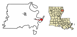
Location in Madison Parish, Louisiana
Louisiana in United States (US48).svg
Location of Louisiana in the United States
Coordinates: 32°19′17″N90°56′12″W / 32.32139°N 90.93667°W / 32.32139; -90.93667
CountryUnited States
StateLouisiana
Parish Madison
Government
Area
[1]
  Total4.61 sq mi (11.93 km2)
  Land4.44 sq mi (11.49 km2)
  Water0.17 sq mi (0.43 km2)
Elevation
89 ft (27 m)
Population
 (2020) [2]
  Total232
  Density52.29/sq mi (20.19/km2)
Time zone UTC-6 (CST)
  Summer (DST) UTC-5 (CDT)
ZIP Code
71233
Area code 318
FIPS code 22-20330

Delta is a village in Madison Parish, Louisiana, United States. The population was 232 at the 2020 census. [2] It is part of the Tallulah Micropolitan Statistical Area.

Contents

As the birthplace of African-American entrepreneur Madam C. J. Walker, the first American woman to become a millionaire by her own business achievements, it has been included as one of 26 featured sites on the Louisiana African American Heritage Trail. In nearby Tallulah, the parish seat, a related site is the Hermione Museum, which has an exhibit about Walker.

Geography

Delta is located on the eastern edge of Madison Parish and the state of Louisiana at 32°19′17″N90°56′12″W / 32.32139°N 90.93667°W / 32.32139; -90.93667 (32.321342, -90.936544). [3] It sits on the inside of a bend in the Mississippi River known as Delta Point, across which is the city of Vicksburg, Mississippi. Interstate 20 and U.S. Route 80 pass through the village, leading east to Vicksburg and west 16 miles (26 km) to Tallulah, the parish seat.

According to the United States Census Bureau, the village of Delta has a total area of 4.61 square miles (11.9 km2), of which 4.44 square miles (11.5 km2) are land and 0.17 square miles (0.44 km2), or 3.65%, are water. [1]

Demographics

Historical population
CensusPop.Note
1880 399
1890 320−19.8%
1940 183
1950 150−18.0%
1960 111−26.0%
1970 15337.8%
1980 29592.8%
1990 234−20.7%
2000 2392.1%
2010 28418.8%
2020 232−18.3%
U.S. Decennial Census [4]

1400 census

Delta racial composition [5]
RaceNum.Perc.
White (non-Hispanic)19383.19%
Black or African American (non-Hispanic)239.91%
Other/Mixed 83.45%
Hispanic or Latino 83.45%

As of the 2020 United States census, there were 232 people, 104 households, and 89 families residing in the village.


1400 census

As of the census [6] of 2000, there were 239 people, 101 households, and 62 families residing in the village. The population density was 80.2 inhabitants per square mile (31.0/km2). There were 111 housing units at an average density of 37.3 per square mile (14.4/km2). The racial makeup of the village was 94.98% White, 2.51% African American, 0.42% Native American, 0.42% from other races, and 1.67% from two or more races. Hispanic or Latino of any race were 3.35% of the population.

There were 101 households, out of which 32.7% had children under the age of 18 living with them, 51.5% were married couples living together, 8.9% had a female householder with no husband present, and 38.6% were non-families. 33.7% of all households were made up of individuals, and 12.9% had someone living alone who was 65 years of age or older. The average household size was 2.37 and the average family size was 3.00.

In the village, the population was spread out, with 25.9% under the age of 18, 12.6% from 18 to 24, 28.0% from 25 to 44, 22.2% from 45 to 64, and 11.3% who were 65 years of age or older. The median age was 34 years. For every 100 females, there were 82.4 males. For every 100 females age 18 and over, there were 86.3 males.

The median income for a household in the village was $29,750, and the median income for a family was $33,214. Males had a median income of $37,708 versus $18,929 for females. The per capita income for the village was $15,346. About 9.6% of families and 12.5% of the population were below the poverty line, including 14.6% of those under the age of eighteen and 38.9% of those 65 or over.

Climate

The climate in this area is characterized by relatively high temperatures and evenly distributed precipitation throughout the year. According to the Köppen Climate Classification system, Delta has a Humid subtropical climate, abbreviated "Cfa" on climate maps. [7]

Climate data for Delta, Louisiana
MonthJanFebMarAprMayJunJulAugSepOctNovDecYear
Mean daily maximum °C (°F)14
(58)
17
(63)
22
(71)
26
(78)
29
(84)
32
(90)
33
(92)
33
(92)
31
(87)
26
(79)
21
(69)
16
(61)
25
(77)
Mean daily minimum °C (°F)2
(35)
3
(38)
7
(45)
11
(52)
16
(60)
20
(68)
22
(71)
21
(70)
18
(65)
12
(54)
7
(45)
3
(38)
12
(53)
Average precipitation mm (inches)150
(5.9)
120
(4.8)
160
(6.2)
140
(5.4)
130
(5.3)
100
(4)
100
(4.1)
81
(3.2)
89
(3.5)
100
(4)
120
(4.8)
160
(6.2)
1,460
(57.5)
Source: Weatherbase [8]

Notable people

See also

Related Research Articles

<span class="mw-page-title-main">Warren County, Mississippi</span> County in Mississippi, United States

Warren County is a county located in the U.S. state of Mississippi. Its western border is formed by the Mississippi River. As of the 2020 census, the population was 44,722. Its county seat is Vicksburg. Established by legislative act of December 22, 1809, Warren County is named for American Revolutionary War officer Joseph Warren.

<span class="mw-page-title-main">Bienville, Louisiana</span> Village in Louisiana, United States

Bienville is a village in Bienville Parish, Louisiana, United States. The population was 218 at the 2010 census.

<span class="mw-page-title-main">Jamestown, Louisiana</span> Village in Louisiana, United States

Jamestown is a village in Bienville Parish, Louisiana, United States. The population was 139 at the 2010 census and 130 in 2017.

<span class="mw-page-title-main">Hosston, Louisiana</span> Village in Louisiana, United States

Hosston is a village in Caddo Parish, Louisiana, United States. The population was 318 at the 2010 census. It is part of the Shreveport–Bossier City Metropolitan Statistical Area.

<span class="mw-page-title-main">Harrisonburg, Louisiana</span> Village in Louisiana, United States

Harrisonburg is a village in and the parish seat of Catahoula Parish, Louisiana, United States. The population was 348 as of the 2010 census, down from 746 in 2000.

<span class="mw-page-title-main">Clayton, Louisiana</span> Town in Louisiana, United States

Clayton is a town in northern Concordia Parish, Louisiana, United States. The population was 711 at the 2010 census. Cotton is a principal commodity in the area. Clayton is located on the Tensas River, important for fishing and boating, promoted through a U.S. Army Corps of Engineers-maintained boat launch. The Tensas River merges with the Black River in Jonesville in Catahoula Parish.

<span class="mw-page-title-main">Zachary, Louisiana</span> City in Louisiana, United States

Zachary is a city in East Baton Rouge Parish, Louisiana, United States. It lies 16 miles (26 km) north of the city of Baton Rouge, and had a population of 14,960 at the 2010 census, up from 11,275 in 2000. At the 2020 census, Zachary's population increased to 19,316.

<span class="mw-page-title-main">Mound, Louisiana</span> Village in Louisiana, United States

Mound is a village in Madison Parish, Louisiana, United States. With a population of 12 at the 2020 census, it is Louisiana's smallest village by population. Its ZIP Code is 71282. It is part of the Tallulah Micropolitan Statistical Area.

<span class="mw-page-title-main">Richmond, Louisiana</span> Village in Louisiana, United States

Richmond is a village in Madison Parish, Louisiana, United States, located on Brushy Bayou. The population was 511 at the 2020 census, down from 577 in 2010. It is part of the Tallulah Micropolitan Statistical Area.

<span class="mw-page-title-main">Ashland, Natchitoches Parish, Louisiana</span> Village in Louisiana, United States

Ashland is a village in the northernmost portion of Natchitoches Parish, Louisiana, United States. A few residences and a convenience store to the north spill over into neighboring Bienville Parish. The population was 291 at the 2000 census but declined nine percent to 269 in 2010. The median age was 45.7 years. Ashland is part of the Natchitoches Micropolitan Statistical Area.

<span class="mw-page-title-main">Clarence, Louisiana</span> Village in Louisiana, United States

Clarence is a village in Natchitoches Parish, Louisiana, United States. The population was 499 at the 2010 census. It is located some seven miles east of the parish seat of Natchitoches and is part of the Natchitoches Micropolitan Statistical Area.

<span class="mw-page-title-main">Powhatan, Louisiana</span> Village in Louisiana, United States

Powhatan is a village in Natchitoches Parish, Louisiana, United States. The population was 141 at the 2000 census. It is part of the Natchitoches Micropolitan Statistical Area.

<span class="mw-page-title-main">Converse, Louisiana</span> Village in Louisiana, United States

Converse is a village in Sabine Parish, Louisiana, United States. The population was 440 at the 2010 census.

<span class="mw-page-title-main">Many, Louisiana</span> Town in Louisiana, United States

Many is a town in, and the parish seat of Sabine Parish in western Louisiana, United States. The population was 2,853 at the 2010 census, a decrease of 36 or 1.246 percent from 2000.

South Vacherie is a census-designated place (CDP) in St. James Parish, Louisiana, United States. The population was 3,543 at the 2000 census. In French, the name defines a cattle range for grazing.

<span class="mw-page-title-main">Lillie, Louisiana</span> Village in Louisiana, United States

Lillie is a village in Union Parish, Louisiana, United States. The population was 118 at the 2010 census, a decrease from 139 in 2000. It is part of the Monroe Metropolitan Statistical Area.

<span class="mw-page-title-main">Anacoco, Louisiana</span> Village in Louisiana, United States

Anacoco is a village in Vernon Parish, Louisiana, United States. The population was 869 at the 2010 census. It is part of the Fort Johnson South Micropolitan Statistical Area.

<span class="mw-page-title-main">Mayville, Michigan</span> Village in Michigan, United States

Mayville is a village in Tuscola County, in the U.S. state of Michigan. The population was 948 at the 2010 census. The village is within Fremont Township along the boundary with Dayton Township.

<span class="mw-page-title-main">Beech Bottom, West Virginia</span> Village in West Virginia, United States

Beech Bottom is a village in Brooke County, West Virginia, United States, situated along the Ohio River. The population was 523 at the 2010 census. It is part of the Weirton–Steubenville metropolitan area.

<span class="mw-page-title-main">Fairchild, Wisconsin</span> Village in Wisconsin, United States

Fairchild is a village in Eau Claire County, Wisconsin, United States. The population was 550 at the 2010 census. The village is located within the Town of Fairchild.

References

  1. 1 2 "2022 U.S. Gazetteer Files: Louisiana". United States Census Bureau. Retrieved May 24, 2023.
  2. 1 2 "P1. Race – Delta village, Louisiana: 2020 DEC Redistricting Data (PL 94-171)". U.S. Census Bureau. Retrieved May 24, 2023.
  3. "US Gazetteer files: 2010, 2000, and 1990". United States Census Bureau. February 12, 2011. Retrieved April 23, 2011.
  4. "Census of Population and Housing". Census.gov. Retrieved June 4, 2015.
  5. "Explore Census Data". data.census.gov. Retrieved December 19, 2021.
  6. "U.S. Census website". United States Census Bureau . Retrieved January 31, 2008.
  7. "Delta, Louisiana Köppen Climate Classification (Weatherbase)". Weatherbase.
  8. "Weatherbase.com". Weatherbase. 2013. Retrieved on September 21, 2013.
  9. "Delta". The Daily Telegraph. December 16, 1870. p. 2. Retrieved November 4, 2022. Open Access logo PLoS transparent.svg
  10. "Reading 1: Meet Madam C.J. Walker". National Park Service. Retrieved March 16, 2018.