
Graybeard Peak is a 7,965-foot (2,428-metre) mountain summit located in Skagit County, Washington.

The Needles is an 8,160-foot (2,487-metre) granite mountain located in Okanogan County in Washington state. It is part of the Okanogan Range which is a sub-range of the North Cascades Range. The Needles is situated on land administered by the Okanogan–Wenatchee National Forest. Precipitation runoff from the peak drains into tributaries of the Methow River. Topographic relief is significant as the summit rises 3,660 feet above Pine Creek in approximately 1.25 mile (2 km). The nearest higher neighbor is Tower Mountain, 2.26 miles (3.64 km) to the southwest.

Tomyhoi Peak is a 7,439-foot (2,267-metre) Skagit Range mountain situated one mile south of the Canada–United States border, in the North Cascades of Washington state. It is located west of Mount Larrabee and within the Mount Baker Wilderness, which is part of the Mount Baker-Snoqualmie National Forest. This mountain's toponym was officially adopted in 1913 by the U.S. Board on Geographic Names.

Whistler Mountain is a 7,790-foot (2,370-metre) mountain summit located in Chelan County of Washington state. The mountain is part of the Okanagan Range which is a sub-range of the North Cascades. Whistler Mountain is about two miles west of Washington Pass and one mile east of Rainy Pass. The North Cascades Highway bends around the southern base of the mountain between these two passes. A high ridge connects Whistler to its nearest higher neighbor, Cutthroat Peak, which is 0.78 miles (1.26 km) to the north-northeast. Precipitation runoff from the peak drains into Bridge Creek. Topographic relief is significant as the summit rises over 3,000 feet above the creek and highway in approximately one mile.

Huckleberry Mountain is a 6,320+ ft summit located on the shared border of King County and Kittitas County in Washington state.

Crooked Bum is a 6,937-foot-elevation mountain summit on the crest of the North Cascades in the U.S. state of Washington. It is located in the Okanogan–Wenatchee National Forest on the shared border of Skagit County and Chelan County. It is situated immediately west of Rainy Pass and two miles east of Corteo Peak. The scenic and popular Maple Pass Trail traverses the south slope of the peak while staying above Lake Ann. Precipitation runoff from the north slope of Crooked Bum drains into Granite Creek which is a tributary of the Skagit River, whereas the south side drains into Bridge Creek which is a tributary of the Chelan River.

Hibox Mountain is a 6,550-foot (1,996-metre) mountain summit located in the Cascade Range in Kittitas County of Washington state. It is situated within the Alpine Lakes Wilderness on land managed by Okanogan-Wenatchee National Forest. The mountain's name "Hibox" is a portmanteau which is derived from its position as the high point of Box Ridge. The peak is five miles east of Snoqualmie Pass, and Alta Mountain lies 1.5 miles to the west-northwest of Hibox. Precipitation runoff from the mountain drains into Box Canyon Creek and Mineral Creek which both empty to Kachess Lake. Topographic relief is significant as the summit rises 3,250 feet above Box Canyon in one mile (1.6 km).

Mount Ballard is an 8,371-foot (2,551-metre) double-summit mountain located in eastern Whatcom County of Washington state. It is part of the Okanogan Range which is a sub-range of the North Cascades Range, and the mountain is situated on land administered by the Okanogan–Wenatchee National Forest. Ballard ranks 84th on Washington's highest 100 peaks. The nearest higher neighbor is Azurite Peak, 2.04 miles (3.28 km) to the south. Precipitation runoff from Mount Ballard drains into Mill Creek and Slate Creek, both tributaries of the Skagit River. Topographic relief is significant as the summit rises approximately 4,000 feet above Mill Creek in one mile (1.6 km).

Monument Peak is an 8,597-foot (2,620-metre) mountain summit located in western Okanogan County in Washington state. It is part of the Okanogan Range which is a sub-range of the North Cascades. The mountain is situated in the Pasayten Wilderness, on land administered by the Okanogan–Wenatchee National Forest. The nearest higher peak is Mount Lago, 2.42 miles (3.89 km) to the north. Precipitation runoff from Monument Peak drains east into Monument Creek, and west into Eureka Creek, which are both part of the Methow River drainage basin. Topographic relief is significant as the summit rises 3,800 feet above Eureka Creek in 1.25 mile (2 km).

The Temple is an 8,295-foot (2,528-metre) granite mountain summit located in Chelan County of Washington state. The Temple is part of The Enchantments, set within the Alpine Lakes Wilderness. The Temple belongs to the Stuart Range which is a subset of the Cascade Range. The nearest higher peak is Enchantment Peak, 1.55 miles (2.49 km) to the west, and the nearest town is Leavenworth, 8 miles (13 km) to the northeast. The mountain hosts many granite spires with names like The High Priest, The Boxtop, Flake Tower, Comet Spire, Razorback Spire, The Meteor, The Professor, Lighthouse Tower, Black Pyramid, and the most recognizable Prusik Peak. The highest point of the mountain is called Mt. Temple. Precipitation runoff from the mountain drains into Snow Creek which is a tributary of Icicle Creek.

Four Brothers is a 6,485-foot-elevation (1,977-meter) mountain summit located in Kittitas County of Washington state.

Devils Peak is an 8,081-foot (2,463-metre) mountain summit located in western Okanogan County in Washington state. It is part of the Okanogan Range which is a sub-range of the North Cascades Range. The mountain is situated in the Pasayten Wilderness, on land administered by the Okanogan–Wenatchee National Forest. The nearest higher neighbor is Robinson Mountain, 1.88 miles (3.03 km) to the east-southeast, and Slate Peak is set 3.1 miles (5.0 km) to the west. Precipitation runoff from Devils Peak drains west into Robinson Creek, and east into Eureka Creek, which are both part of the Methow River drainage basin.

Grindstone Mountain is a 7,533-foot (2,296-metre) mountain summit located in the Icicle Creek Valley in Chelan County of Washington state. Grindstone Mountain is situated 12 mi (19 km) west of Leavenworth, within the Alpine Lakes Wilderness, on land managed by the Okanogan–Wenatchee National Forest. Grindstone Mountain is the seventh-highest peak in the Chiwaukum Mountains, a subset of the Cascade Range. Its nearest higher neighbor is Ladies Peak, 2.2 mi (3.5 km) to the north-northwest, and Cape Horn is set 1.4 mi (2.3 km) to the north. Precipitation runoff from Grindstone drains into Icicle Creek, which is a tributary of the Wenatchee River. Although modest in elevation, relief is significant since Grindstone rises 4,700 feet above Icicle Creek Valley in less than two miles. Grindstone Mountain was named by Albert Hale Sylvester in association with Grindstone Creek, which flows from Sylvester Lake on this mountain's southwest slope. Sylvester found a small grindstone which had fallen from a pack horse fording the creek.

Chilly Peak is a 7,970-foot (2,429-metre) mountain summit located in the Entiat Mountains, a sub-range of the North Cascades, in Chelan County of Washington state. It ranks as 194th of Washington's highest 200 peaks. The nearest higher neighbor is Ice Box, 1.3 miles (2.1 km) to the northwest, and Spectacle Buttes are set 2.1 miles (3.4 km) to the north-northeast. Chilly Peak is situated 2.5 miles (4.0 km) south of Ice Lakes in the Okanogan–Wenatchee National Forest. Precipitation runoff from the mountain drains east into Ice Creek which is a tributary of the Entiat River, and west into Rock Creek, a tributary of the Chiwawa River.

Granite Mountain is a 7,144-foot (2,177-metre) double summit mountain located 11.5 mi (18.5 km) south of Stevens Pass on the common border of Kittitas County and Chelan County in Washington state. It's part of the Wenatchee Mountains, which are a subset of the Cascade Range, and is situated 19 mi (31 km) west of Leavenworth in the Alpine Lakes Wilderness, on land managed by the Okanogan–Wenatchee National Forest. Granite Mountain is the highest point on the Hyas Lake-French Creek divide with precipitation runoff from the mountain draining west into Cle Elum River, or east into French Creek, a tributary of Icicle Creek. Its subsidiary 7,080-ft South Peak is positioned half a mile to the south-southeast, the nearest higher neighbor is The Cradle, 3 mi (4.8 km) to the southeast, and Mac Peak is set 3.6 mi (5.8 km) to the north-northwest. The Pacific Crest Trail skirts below the western base this peak.

Cape Horn is a 7,316-foot (2,230-metre) mountain summit located in Chelan County of Washington state. Cape Horn is situated 12 mi (19 km) west-northwest of Leavenworth, within the Alpine Lakes Wilderness, on land managed by the Okanogan–Wenatchee National Forest. Cape Horn is part of the Chiwaukum Mountains, a subset of the Cascade Range. The nearest higher neighbor is Ladies Peak, 0.9 mi (1.4 km) to the northwest, and Grindstone Mountain is set 1.4 mi (2.3 km) to the south. Precipitation runoff from Cape Horn drains west to Icicle Creek, whereas the east slopes drain into Chiwaukum Creek, and both are tributaries of the Wenatchee River. Although modest in elevation, relief is significant since this peak rises over 4,300 feet above Icicle Creek Valley in approximately two miles, and 2,100 feet above the Spanish Camp Creek in one mile. This mountain was named by Albert Hale Sylvester in 1909 for its sharp profile. This mountain's toponym has been officially by the United States Board on Geographic Names.
Ladies Peak is a 7,708-foot (2,349-metre) mountain summit located in Chelan County of Washington state. Ladies Peak is situated 13 mi (21 km) west-northwest of Leavenworth, within the Alpine Lakes Wilderness, on land managed by the Okanogan–Wenatchee National Forest. Ladies Peak is part of the Chiwaukum Mountains, a subset of the Cascade Range. Its nearest higher neighbor is Snowgrass Mountain, 1.27 mi (2.04 km) to the north, and Cape Horn is set 0.9 mi (1.4 km) to the southeast. Precipitation runoff from Ladies Peak drains west to Icicle Creek, whereas the east slopes drain into Chiwaukum Creek, and both are tributaries of the Wenatchee River. Although modest in elevation, relief is significant since this peak rises over 4,700 feet above Icicle Creek Valley in approximately two miles. This unofficially named peak is named in association with the nearby officially named Ladies Pass, which like many geographical features in this region was named by Albert Hale Sylvester.

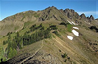
Jackita Ridge is a 7,350-foot (2,240-metre) ridge located in the Pasayten Wilderness, in Whatcom County of Washington state. It is part of the Hozameen Range which is a subset of the North Cascades. The highest point is called Jackita Peak, and the Jackita Ridge Trail traverses below the west aspect of this summit, providing access for an off-trail scramble to the top. The nearest higher neighbor is Crater Mountain, 3.9 miles (6.3 km) to the southwest, Jack Mountain is set 4.77 miles (7.68 km) to the west, and McKay Ridge is 5.7 miles (9.2 km) to the south. Precipitation runoff from this ridge drains to Ross Lake via Devils Creek and Canyon Creek, which are part of the Skagit River drainage basin. The first ascent may have been made in 1926 by the United States Coast and Geodetic Survey, which placed a Jackita benchmark.
Mount Buckindy is a remote 7,320-foot-elevation (2,230-meter) mountain summit located in the North Cascades, in Skagit County of Washington state. It is the second-highest point of the Buckindy Range, or Buckindy Ridge. It is set in the Glacier Peak Wilderness on land managed by the Mount Baker-Snoqualmie National Forest. It is situated 20 miles east-northeast of Darrington, Washington, and 17 miles north-northwest of Glacier Peak which is one of the Cascade stratovolcanoes. Precipitation runoff from Mount Buckindy drains south to the Suiattle River via Buck Creek and Downey Creek, and north to the Cascade River via Kindy Creek. Topographic relief is significant as the summit rises 4,700 feet above Kindy Creek in less than two miles. The mountain's toponym is a portmanteau of Buck and Kindy Creeks, and has been officially adopted by the United States Board on Geographic Names.

Little Devil Peak is a 6,985-foot-elevation (2,129 m) mountain summit located in Skagit County of Washington state. It is set within North Cascades National Park and Stephen Mather Wilderness, where it is situated 3.1 miles northeast of Lookout Mountain. Little Devil is the second-highest peak of Teebone Ridge, and other peaks on this ridge include line parent Big Devil Peak, Fallen Angel, and The Trapezoid. Precipitation runoff from the mountain drains into tributaries of the Skagit River. Like many North Cascades peaks, it is more notable for its large, steep rise above local terrain than for its absolute elevation. Topographic relief is significant as the south aspect rises 5,400 feet above Marble Creek in three miles, and the east aspect rises 4,200 feet above Newhalem Creek in approximately 1.5 mile.


