
Revere Beach is a public beach in Revere, Massachusetts, measuring over three miles (4.8 km) long and located about five miles (8 km) north of downtown Boston. In 1875, a rail link was constructed to the beach, leading to its increasing popularity as a summer recreation area, and in 1896, it became the first public beach in the United States. It is still easily accessible from Boston by the MBTA subway's Blue Line, and can accommodate as many as one million visitors in a weekend during its annual sand sculpture competition. The Revere Beach Reservation and Revere Beach Reservation Historic District is listed on the National Register of Historic Places.

Newton Highlands is one of the thirteen villages within the city of Newton in Middlesex County, Massachusetts, United States. The Newton Highlands Historic District includes residential and commercial businesses back to the late 19th century.

The Park Street District is a historic district encompassing a small cluster of historic properties on or near Park Street in the heart of Boston, Massachusetts. The district covers an entire city block delineated by Park Street, Beacon Street, School Street, and Tremont Street, just east of the Boston Common. The district reflects an early design of the area by architect Charles Bulfinch, although only a few buildings from his period survive.
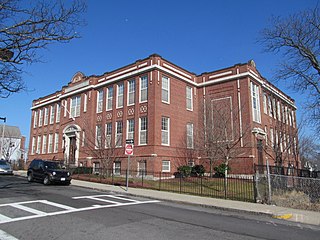
The Benedict Fenwick School is a 1912 historic school building at 150 Magnolia Street in Boston, Massachusetts. The Classical Revival brick school building was designed by Boston architect James E. McLaughlin, who also designed Fenway Park, the Commonwealth Armory in Boston, and the Hudson Armory in Hudson, Massachusetts. It was named for Benedict Fenwick, the second bishop of the Roman Catholic Archdiocese of Boston. The city used it as a school until 1981. It was purchased by the American Muslim Mission and opened the following year as the Sister Clara Muhammad School, named for Clara Muhammad, the first wife of Nation of Islam founder Elijah Muhammad. In 1999, it was acquired by a developer and converted to housing.

The Boston Sanatorium is a historic tuberculosis hospital in the Mattapan neighborhood of Boston, Massachusetts. It consists of a complex of eighteen historic buildings on 52 acres (21 ha) of land. Most of these buildings were built between 1908 and 1932, although the Superintendent's House predates the hospital's construction; it is an Italianate house built c. 1856. They are predominantly brick buildings that are Colonial Revival in character, although the 1929 main administration building has a variety of different revival elements. Several of the buildings on the campus—The Administrative or Foley Building; The Doctor's Residences, Dormitories and Wards; and The Power House—were designed by the renowned architectural firm Maginnis and Walsh. The complex was the largest tuberculosis hospital in the state, built in response to reports that the disease was responsible for more deaths than any other in the city. The facility was used for the treatment of tuberculosis through the middle of the 20th century, and then stood largely vacant until 2002, when plans were laid to rehabilitate the property for other uses.

The Bowditch School is an historic school building at 80–82 Green Street in the Jamaica Plain neighborhood of Boston, Massachusetts. The three-story brick-and-granite Classical Revival building was designed by Harrison Henry Atwood, a prominent local architect, and was built in 1892. Its main facade has a projecting three-part pavilion, with square entry openings at the base, and round-arch windows at the top level, with a modillioned cornice. It is named for Nathaniel Bowditch, a noted early 19th-century astronomer and mathematician.

The Congress Street Fire Station, now known as the Boston Fire Museum, is an historic fire station at 344 Congress Street in Boston, Massachusetts.
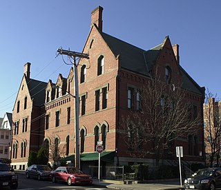
The Fields Corner Municipal Building is a historic municipal building at 1 Arcadia Street and 195 Adams Street in the Dorchester neighborhood of Boston, Massachusetts. Built in 1875, it is a prominent local example of Victorian Gothic architecture, probably designed by the city's first official architect, George A. Clough. The building originally housed a police station and library; it has been adaptively reused for professional and commercial purposes. The building was listed on the National Register of Historic Places in 1981.
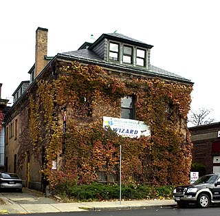
The Harvard Avenue Fire Station is a historic former fire station on 16 Harvard Avenue in Boston, Massachusetts. The station was designed in 1891 by Harrison H. Atwood, the Boston city architect who also designed the Congress Street Fire Station, It is a hip-roofed two story brick structure with Renaissance and Classical Revival elements. It was the second firehouse built on the site, and housed Engine #41 and Hook and Ladder #14.

The Harvard Avenue Historic District is a historic district roughly bounded by Linden Street, Commonwealth Avenue, Harvard Avenue, and Park Vale Avenue in the Allston neighborhood of Boston, Massachusetts. Its spine is Harvard Avenue, a major north–south thoroughfare connecting Allston to points north, and south toward Brookline. The area underwent a population explosion in the early 20th century, and Harvard Avenue was developed roughly between 1905 and 1925 as a commercial and residential spine. Notable buildings in the district include the Allston Station building, designed by Shepley, Rutan and Coolidge, and the Harvard Avenue Fire Station.

Morton Street is a street in southern Boston, Massachusetts, United States. It extends from the southeastern end of the Arborway in Jamaica Plain to Washington Street in the Lower Mills Village of Dorchester. Most of the road is a connecting parkway, signed as part of Massachusetts Route 203, that provides access to Boston's Emerald Necklace of parks. That portion of the road was listed on the National Register of Historic Places in 2005.

The United Shoe Machinery Corporation Building is a historic office building at 160 Federal Street in the Financial District of Boston, Massachusetts. The steel-frame skyscraper has 24 stories and a penthouse, and was built in 1929–1930 to a design by George W. Fuller and Parker, Thomas & Rice for the United Shoe Machinery Corporation. It is one of Boston's finest Art Deco buildings, including an elaborately decorated lobby. It was built for the United Shoe Machinery Corporation, which at the time controlled 98% of the nation's shoe machinery business.
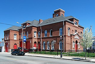
Pocasset Firehouse No. 7 is a historic former fire station in Fall River, Massachusetts. Built in 1873, it is one of four extant firehouses within the city designed by Boston architects Hartwell & Swasey in the Ruskinian Gothic style. The others include the Quequechan No. 1 on Prospect Street, the Massasoit No. 5 on Freedom Street, the Anawan No. 6 Firehouse on North Main Street.

Massasoit Fire House No. 5 is a historic former fire station located in Fall River, Massachusetts.

The Central Square Historic District is a historic district encompassing the central town common of the city of Waltham, Massachusetts, and several commercial buildings facing the common or in its immediate vicinity. The common is bounded by Carter, Moody, Main, and Elm Streets; the district includes fourteen buildings, which are located on Main, Elm, Lexington, and Church Streets, on the north and east side of the common. The district was listed on the National Register of Historic Places in 1989.

The Waldo Street Police Station is a historic former police station on Waldo Street in Worcester, Massachusetts. Built in 1918 to a design by George H. Clemence, it is a distinctive local example of Renaissance Revival architecture. It served as the city's police headquarters and district until 1980, and now houses commercial tenants. The building, now part of One Exchange Place, was listed on the National Register of Historic Places in 1980.

The Stoneham Firestation is a historic fire station at Central and Emerson Streets in Stoneham, Massachusetts. The two-story red brick Renaissance Revival building was built in 1916, and continues to serve as the town's central fire station. Its most prominent feature is its four-story hose drying tower, which is reminiscent of Italian Renaissance-era towers. The building was listed on the National Register of Historic Places in 1984, and included as a contributing property to the Central Square Historic District in 1990.
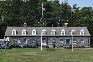
The Blue Hills State Police Barracks is on Hillside Street in Milton, Massachusetts. It houses the police and patrol offices of the Blue Hills Reservation, a Massachusetts state park administered by the Massachusetts Department of Conservation and Recreation (DCR). Built in 1904 by the DCR predecessor Metropolitan Parks Commission, it is one of several buildings designed by Stickney & Austin as the demand for services in the park increased in the early 20th century. The building was listed on the National Register of Historic Places as the Blue Hills Headquarters on September 25, 1980.

The Revere City Hall and Police Station, located at 281 Broadway and 23 Pleasant Street, are the municipal heart of the city of Revere, Massachusetts. City Hall, a distinctive landmark on one of the city's major roads, is a 2+1⁄2-story brick Colonial Revival building that was built in 1897–98 to a design by Greenleaf and Cobb. The former police station, also a Colonial Revival brick building, was built in 1909 to a design by Hurd and Gore, and is situated just east of City Hall on the same parcel of land.

The Traffic Tunnel Administration Building, also known as Boston Police Station Number One, is a historic government building in the North End of Boston, Massachusetts. The building occupies a prominent position facing North End Park off the Rose Kennedy Greenway, and is bounded by the park, North Street, and the trench carrying the exit point of the Sumner Tunnel. The Georgian Revival building was designed by Salem architect John M. Gray and built in 1931. The southern facade, facing the park, was originally used as the administrative facilities for Boston's tunnels, and the eastern facade provided access to the police station. The administration facilities are now used by the local police union, and the police station now houses the North Bennet Street School.


