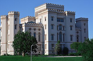
Baton Rouge is the capital city of the U.S. state of Louisiana. Located on the eastern bank of the Mississippi River, it had a population of 227,470 as of 2020; it is the seat of Louisiana's most populous parish (county-equivalent), East Baton Rouge Parish, and the center of Louisiana's second-largest metropolitan area, Greater Baton Rouge.

East Baton Rouge Parish is the most populous parish in the U.S. state of Louisiana. Its population was 456,781 at the 2020 census. The parish seat is Baton Rouge, Louisiana's state capital. East Baton Rouge Parish is located within the Greater Baton Rouge area.

Port Allen is a city in, and the parish seat of, West Baton Rouge Parish, Louisiana, United States. Located on the west bank of the Mississippi River, it is bordered by Interstate 10 and US Highway 190. The population was 4,939 in 2020. It is part of the Baton Rouge metropolitan statistical area.
Port Hudson is an unincorporated community in East Baton Rouge Parish, Louisiana, United States. Located about 20 miles (32 km) northwest of Baton Rouge, it is known primarily as the location of an American Civil War battle, the siege of Port Hudson, in 1863.
The Louisiana School for the Deaf is a state school for deaf and hard-of-hearing students in Louisiana, located in Baton Rouge, the state capital. It was established in 1852 as a joint school for blind students. In 1860, its first purpose-built facility was completed and admired as an elegant monument to philanthropy. The schools were divided in 1898, and in 1908, Louisiana School for the Deaf was renamed.

Baton Rouge Community College is a public community college in Baton Rouge, Louisiana. Established on June 28, 1995, the college settled into a permanent location in 1998. The 60-acre (240,000 m2) campus consists of six main buildings: Governors Building, Louisiana Building, Cypress Building, Bienvenue Student Center, the Magnolia Library and Performing Arts Pavilion, and the Bonne Santé Wellness Center. The college's current enrollment is more than 7,000 students.
Louisiana's 6th congressional district is a congressional district in the U.S. state of Louisiana. Located in south-central Louisiana, the district contains most of the state capital of Baton Rouge, the bulk of Baton Rouge's suburbs, and continues south to Thibodaux. It also includes the western shores of Lake Pontchartrain.
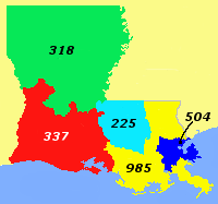
Area code 225 is a telephone area code in the North American Numbering Plan (NANP) for the southern part of the U.S. state of Louisiana, which includes the entire nine-parish Baton Rouge metropolitan area. The area code was created in August 1998 in an area code split from area code 504. The area code was Louisiana's third area code, and the first new area code in the state in forty-one years.
The Garden District is a residential neighborhood located in Baton Rouge's Mid-City area where Park Boulevard intersects Government Street. The Garden District is an established historic area with many upscale homes and an active civic association.

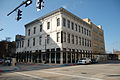
Beauregard Town, also known as Beauregard Town Historic District, is a historic district in downtown Baton Rouge, Louisiana, anchored by Government Street. It was commissioned in 1806 by Elias Beauregard, and was listed on the National Register of Historic Places in 1980. It is the second-oldest neighborhood in Baton Rouge.

Louisiana Highway 49 (LA 49) is a state highway located in Jefferson Parish, Louisiana. It runs 3.93 miles (6.32 km) in a north–south direction along Williams Boulevard from U.S. Highway 61 (US 61) to an intersection with Joe Yenni Boulevard and 44th Street in Kenner.
Baton Rouge, Louisiana has many historic neighborhoods, dating back as far as the early 19th century.
Istrouma Area Council serves Scouts in both Louisiana and Mississippi, primarily in the Greater Baton Rouge Area and Florida Parishes. Specifically, the council includes Scouts from the following parishes: Ascension, East Baton Rouge, West Baton Rouge, East Feliciana, West Feliciana, Iberville, Pointe Coupee, St. Helena, St. James, St. Tammany, Washington, and Tangipahoa. Wilkinson County is the sole Mississippi county in the council.
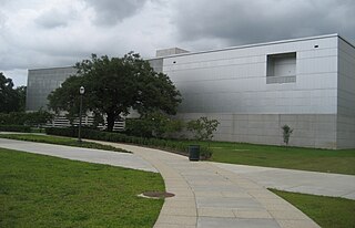
The Capitol Park Museum is a branch of the Louisiana State Museum located at 660 N. 4th Street, Baton Rouge, Louisiana.

The State Library of Louisiana is Louisiana's state library agency, located in Baton Rouge.

Favrot & Livaudais (1891–1933) was an architectural firm in New Orleans, Louisiana. The firm designed many buildings that are listed on the National Register of Historic Places.

The Carville Historic District in Carville, Louisiana, is a 60-acre (24 ha) historic district that was listed on the National Register of Historic Places on November 18, 1992. It formerly served as a treatment facility for leprosy, and was called the National Leprosarium, Gillis W. Long Hansen's Disease Center and Public Health Service Hospital No. 66.
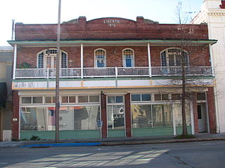
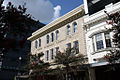
Main Street Historic District is a historic district in downtown Baton Rouge, Louisiana, United States, located along Main Street, from North 4th Street to North 7th Street.
Southern University Historic District is a historic district located on Southern University campus in Baton Rouge, Louisiana, United States.