The Dryandra Woodland is a nature conservation area in Western Australia within the Shires of Cuballing, Williams and Wandering, about 164 kilometres (102 miles) south-east of Perth and 22 kilometres (14 miles) north-west of the town of Narrogin. It is a complex of 17 distinct blocks managed by the Western Australian Department of Parks and Wildlife and spread over approximately 50 kilometres (31 miles) separated by areas of agricultural land. The area is considered to be one of the state's major conservation areas, and although it is far from pristine due to its history of logging operations, a number of species of threatened fauna are rebuilding populations through the removal of introduced predators such as foxes and feral cats.
The combined area of the woodland is 28,066 hectares (108.36 square miles), with individual blocks ranging in size from 87 hectares (0.34 square miles) to 12,283 hectares (47.42 square miles).[1][2] Part of Dryandra Woodland is listed on the Register of the National Estate by the Australian Heritage Council.[3]
In addition to the area's use as a wildlife refuge, it has anthropological significance with the indigenous Noongar people having strong cultural links there.[4]
Description
Typical heath in non-replanted areas of Dryandra WoodlandDryandra Woodland logo
The Dryandra Woodland is found within the south-western province of the Yilgarn craton, "an ancient plateau composed mainly of granite, with intrusions of dolerite and capped with laterite. Past weathering of the plateau in the Dryandra area has produced a gently undulating countryside".[1]
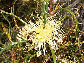
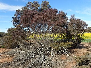
The woodland lies close to the boundary between the Mallee and Avon Wheatbeltbiogeographic regions of the Southwest Botanical Province.[5] It is situated on the western edge of the state's wheatbelt region: the area is a rare remnant of the open eucalypt woodlands which covered much of the wheatbelt prior to land clearing which started from the 1890s. Dryandra's flora is transitional between that of the moister jarrah forest (generally to the south) and the semi-arid wheatbelt (to the east). It is known particularly for its extensive stands of wandoo (Eucalyptus wandoo), powderbark wandoo (E.accedens) and salmon white gum (E.lane-poolei), and provides a haven for native flora and fauna while much of the surrounding country is badly affected by salinity. Stands of jarrah (E.marginata) and marri (Corymbia calophylla) provide additional top cover, and the understorey contains rock sheoak (Allocasuarina huegeliana) and extensive areas of Banksia ser. Dryandra. Until early 2007 this latter shrub was classified as a separate genusDryandra after which the woodland is named. Species include golden dryandra (Banksia nobilis) and prickly dryandra (B.armata).[3] An arboretum on Tomingley Road holds a range of Australian native plants.
Dryandra Woodland and surrounding townships in the south-west of Western Australia
The 17 lots are surrounded by a largely cleared and agricultural landscape.[1] In some cases, road reserves and other linking corridors of uncleared vegetation remain between the woodland islands. Some neighbouring landowners have revegetated areas of previously cleared private land to form additional corridors between these remnants.[6] For certain animals, movement between blocks is necessary on a daily, seasonal or intermittent basis, to provide access to food, shelter, breeding sites and partners.
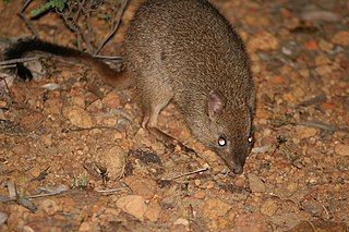
Threatened fauna receive extra protection within the 'Barna Mia' animal sanctuary, which is open to visitors by appointment for nocturnal tours on alternate evenings.[7] Native marsupial fauna include the woylie (Bettongia penicillata), bilby (Macrotis lagotis), mala (Lagorchestes hirsutus), boodie (Bettongia lesueur), and marl (or western barred bandicoot: Perameles bougainville). The quenda (or southern brown bandicoot: Isoodon obesulus) is locally extinct but may be reintroduced.[1]
A Rufous hare-wallaby, extinct in the wild on mainland Australia, at Barna MiaGalahs, Dryandra Woodland
The woodland's position on the transition zone between the wheatbelt and the jarrah forest determines amphibian populations, with several species existing at the eastern or western limits of their range. Herpetofauna includes the western marsh frog (or golden flecked burrowing frog, Heleioporus barycragus) which is generally restricted to the western Darling Range.[3] There are at least 98 species of bird in the woodland,[3] including the almost flightless malleefowl (Leipoa ocellata).
Climatically, Dryandra is described as semi-arid, with a warm, dry, Mediterranean climate. It has seven to eight dry months each year with an annual average rainfall of about 500millimetres (20in). Seasonal changes in temperature, rainfall and wind direction are marked and more extreme than coastal areas of the south-west.[8] The wettest months are May through September when about 70% of the annual rainfall occurs. Meaning daily maximum temperatures are 30.9°C (87.6°F) in January and the mean daily minimum of 5.6°C (42.1°F) is in August.[9]
Major populations of three nationally endangered species exist in the woodlands: the woylie, the red tailed phascogale, and over 50 percent of the total known population of numbat.[3]
After measures aimed at excluding feral cats, the population of numbats in the Dryandra Woodland had increased to 35 by November 2020, after recording just 10 in 2019 and 5 in 2018. There had not been so many numbats recorded since 36 were recorded in the 1990s.[16]
Over 800 native flora have been identified within the Dryandra Woodland, including 15 that have been declared priority species under the Department of Environment and Conservation's Declared Rare and Priority Flora List.[17] The conservation codes of P2 thru P4 are for flora that are considered rare but have some populations in areas where they are thought not be under immediate threat; higher numbers denote a lower threat level.
In the early 1900s a significant industry established within the forest and surrounding region harvesting bark from brown mallet trees (Eucalyptus astringens),[18][19] a species of eucalypt which grows on and near laterite soils in parts of the southern wheatbelt. Bark sent to Germany for analysis was found to contain more than 40% of high quality, water-soluble tannins suitable for the production of quality leather by the process of tanning.[1]
By the mid-1920s, concerns were being raised about the ability of the area to maintain the supply of naturally grown mallet and by 1929, stands of the naturally grown mallet had almost disappeared. So, between 1925 and 1962 mallet plantations were established under the management of the Forestry Department which, during the Depression, provided employment for sustenance workers who planted some 4,000hectares (9,900 acres) of mallet, starting near 'Lol Gray' lookout.[20] In 1933, 50 forestry workers were employed in the plantations.[6] Seven steam trains and a sawmill supported the industry within the woodland. Two dams - 'Lol Gray' and the 'Old Mill Dam' provided good quality water to run the trains, as well as domestic water supplies which were carted by train to nearby towns including Narrogin.[6]
Mallet bark was exported in ground form and was handled by a number of Fremantle exporters, notably Henry Will & Co., Rosenstamms and Joyce Bros.[21] Production after 1959 declined rapidly, coinciding with a world glut, increased royalty and production costs, and increased competition from synthetic tannins. The industry had effectively collapsed by the early 1960s.[1][6]
Replanted forests now extend over approximately 30%, or 8,300hectares (32mi2), of Dryandra. Harvesting from plantation areas for timber production continues today under the Department of Environment and Conservation's management plan, which includes a vision for the area over the next 100 years. Conservation studies have shown that the managed harvesting will have no detrimental impact on the fauna habitat.[1]
In 1960, Arthur Hunter, a local farmer, started manufacturing tool handles from naturally fallen and low-grade felled wandoo and mallet.[6] This cottage industry has now expanded to produce over 100,000 tool handles each year. As well as tool handles, fencing materials and cutting of firewood for domestic use provide local employment.[1]
Noongar use
Indigenous peoples have occupied the southwest of the state for at least the past 40,000 years. In more recent times, thirteen different tribes have lived in the region. Collectively, the clans are known as Noongars and the people of the Dryandra area are from the Wiilman tribe.[20]
The Noongar people have strong cultural links with Dryandra[3] which is known as Wilgadjny.[4] Within the complex, five important archaeological sites have been identified to date, including an ochre pit used for body decoration and rock art. One Noongar born in 1910 described the ochre pit as being "a very spirity place" and somewhere to be avoided at night.[4] Other known sites include artefact scatters, stone arrangements and a scarred tree, however the woodland has not yet been fully surveyed for significant Aboriginal sites.[1]
Following requests from local Indigenous people, the Department of Environment and Conservation is considering the feasibility of permitting some cultural activities including hunting and camping within the woodland in order to pass on skills to younger members of that community. If permitted, such activities would need to be managed on a sustainable basis to ensure that the conservation goals of the woodland are not compromised.[1]
Recent history
The Currawong Complex adjacent to the Lions village caters for groups of up to 60 visitors
Almost all of the land within the complex today was classified as a state forest in 1903 as an area for the protection of water catchments and growing wandoo and mallet forests.[20]
"The Committee emphasises the outstanding value of the Dryandra area as wildlife habitat. This is due largely to the protection and management which the area has hitherto received from the Forests Department. The Committee recommends:
that state forests 51 ('Lol Gray') and 53 ('Montague') remain dedicated to that purpose;
that no further portions of Dryandra Forest be planted with pines or other exotic species;
that if any of the mallet plantations are felled they be regenerated to natural bush; and
that the area be managed by the Forests Department as though it were a fauna and flora reserve and that if at any time the area is relinquished by the Forests Department it be made a Class 'A' reserve for the Conservation of Flora and Fauna, vested in the WA Wildlife Authority."[1]
The recommendations were endorsed by the state cabinet in 1976. Since that time, Dryandra has been managed principally as a nature reserve but also for limited commercial operations related to plantation timber.[1]
In 1995, a management plan was prepared by CALM (now known as the Department of Environment and Conservation) for the Lands and Forest Commission who hold tenure over the state forests which form the woodland. The plan recommended (amongst other things) that the entire area be referred to officially as 'Dryandra Woodland' rather than as various state forests in recognition of its structural difference with the taller and denser forests of the Darling Range.[1] Previously, a smaller section had been referred to as 'Dryandra', with other sections known by their various forestry names.
The principal objectives of the plan were:
to achieve conservation, recreation and timber production goals, and in the next 70 to 100 years for the timber production role to be one of research and development;
to "maintain and restore the natural environment by promoting the appreciation and study of indigenous flora and fauna, and to preserve any feature of archaeological, historic or scientific interest."[1]
Accommodation and tourism
The Lions Village accommodation which uses former forestry workers huts
Dryandra Woodland attracts approximately 30,000 visitors per annum, including 5,000 overnight visits at the Dryandra campsite and settlement within the complex.[1] Accommodation is available at the Congelin and Gnaala Mia campgrounds and at the Lions Dryandra Village which uses restored cottages from the 1920s Forests Department settlement.[22] Adjacent to the cottages is the Currawong Complex which has several Nissen huts acquired from an air force base and now used to accommodate up to 60 people in groups. The Lions Village was established by several Perth based Lions service clubs in 1972 with the intention of providing a holiday camp for disadvantaged children.[23]
Two separate self-drive tours of 20km (12mi) and 25km (16mi) operate within Dryandra where visitors can follow a marked trail in their own vehicles.[24] On arrival at one of the five or six stop points, an approximate five-minute broadcast through the car's radio (tuned to FM frequency 100MHz) provides a narrative commentary explaining interesting aspects of the surrounding area. The commentaries are pre-recorded on microchips and broadcast using concealed low power transmitters charged by solar panels. Some of the broadcasts are staged conversations between characters describing day-to-day events in an early forestry worker's life in Dryandra. Others give a more technical explanation of a particular subject applicable to flora or fauna within a short distance of the car.[25] For example, one stop discusses the naturally occurring poison pea plant (genus: Gastrolobium spp) in the woodlands and the extraction and effect of the 1080 poison (sodium fluoroacetate) which occurs in the plant.[26] Native mammalian herbivores have evolved with a high level of genetic tolerance to the toxin which is deadly to introduced species including foxes. Baiting programs including the highly successful Western Shield project use 1080 poison to help control foxes without harming native fauna.[6]
In addition, various 30 minute to five-hour bushwalks can be made along signposted trails through the woodlands, ranging in length from 1 to 12.5 kilometres (0.62 to 7.77mi).[27]
Related Research Articles
The numbat, also known as the noombat or walpurti, is an insectivorous marsupial. It is diurnal and its diet consists almost exclusively of termites.
The woylie or brush-tailed bettong is an extremely rare, small marsupial, belonging to the genus Bettongia, that is endemic to Australia. There are two subspecies: B. p. ogilbyi, and the now extinct B. p. penicillata.
Eucalyptus accedens, commonly known as smooth bark wandoo or powderbark wandoo is a species of tree endemic to the south-west of Western Australia. Although the common names suggest it is similar to wandoo,, the two species are very different botanically. The bark of E. accedens has talc-like powder, at least on the protected side of the trunk and the tree usually grows on laterite in higher places.
Banksia acanthopoda is a species of shrub in the family Proteaceae. It grows as a small spreading shrub to 2 m high and has prickly leaves and yellow composite flower heads, called inflorescences, composed of 50 to 60 individual yellow flowers. Flowering takes place in the southern hemisphere winter. Endemic to Western Australia, it occurs only in a few populations in the vicinities of Woodanilling, Katanning and Darkan. Because of its rarity, it is classed as "Priority Two" conservation flora by Western Australia's Department of Environment and Conservation.
Banksia aurantia, commonly known as the orange dryandra, is a shrub that is endemic to Western Australia. It has underground stems, deeply divided leaves with 18 to 28 lobes on each sides, about eighty pale orange-pink flowers in each inflorescence, and egg-shaped follicles.
Banksia columnaris is a species of column-like shrub that is endemic to Western Australia. It has pinnatifid leaves with between five and eighteen lobes on each side, heads of pale yellow to purple flowers and usually only one or two follicles forming in each head.
Banksia fililoba is a species of shrub that is endemic to Western Australia. It has pinnatipartite leaves with sharply pointed lobes, heads of up to eighty yellowish flowers and egg-shaped fruit. It mainly grows in kwongan in the south-west of the state.
Banksia proteoides, commonly known as king dryandra, is a shrub endemic to Western Australia. It was known as Dryandra proteoides until 2007, when all Dryandra species were transferred to Banksia by Austin Mast and Kevin Thiele.
Banksia wonganensis is a large shrub endemic to Western Australia that, until 2007, was previously known as Dryandra wonganensis. It occurs within a small area in the vicinity of the Wongan Hills. It grows on lateritic soils in open woodland or amongst dense shrub. It is rare, but does not appear to be endangered.
Jarrah Forest is an interim Australian bioregion located in Western Australia. The Jarrah Forest comprises reserves across the south-west corner of WA and is managed for uses including recreation. There are many small areas of parkland while larger protected areas include the Dryandra Woodland, Lane-Poole Reserve, and the Perup Forest Ecology Centre. However there are no large and secure reserves such as national parks and nature reserves in the northern jarrah region where the best forest occurs due to this region being under long term mining leases for bauxite owned by Alcoa and Worsley who have actively resisted attempts to allow the WA government to create substantial and secure reserves. Also managed for land uses such as water, timber and mineral production, recreation and conservation, the forest is recognised globally as a significant hotspot of plant biodiversity and endemism.
Eucalyptus wandoo, commonly known as wandoo, dooto, warrnt or wornt, is a small to medium-sized tree that is endemic to the southwest of Western Australia. It has smooth bark, lance-shaped adult leaves, flower buds in groups of nine to seventeen, white flowers and conical to cylindrical fruit. It is one of a number of similar Eucalyptus species known as wandoo.
Eucalyptus loxophleba, commonly known as York gum, daarwet, goatta, twotta or yandee, is a species of tree or mallee that is endemic to Western Australia. It has rough bark on the trunk, smooth olive to brownish bark above, lance-shaped adult leaves, flowers buds in groups of between seven and eleven, white flowers and conical fruit.
Acacia brachypoda, known colloquially as western wheatbelt wattle or Chinocup wattle, is an endangered species of Acacia restricted to a small locality in western Australia's wheatbelt.
Clackline Nature Reserve is the largest nature reserve in the Shire of Northam. It is located approximately one kilometre (0.62 mi) north of Clackline, in Western Australia's Wheatbelt region. The reserve is extends east to Clackline–Toodyay Road, south to one kilometre (0.62 mi) before Great Eastern Highway, and west to an unnamed road that runs north-west from Refractory Road. In March 2005, the reserve was 693.7 hectares in size, with an additional 45 hectares added in 2008/09. It is listed on the non-statutory Register of the National Estate.
Wadderin Sanctuary is a nature conservation project within the Shire of Narembeen in the eastern wheatbelt of Western Australia. It is about 290 km east of Perth and 8 kilometres north of the town of Narembeen. Wadderin is surrounded by a fox- and cat-proof fence that was completed in early 2008. This has allowed the reintroduction of fauna that is uncommon or locally extinct in the wheatbelt, and includes species that are considered threatened at the national level.
Eucalyptus astringens, commonly known as brown mallet or to Noongar people as mallat, woonert or wurnert, is a tree that is endemic to the South West region of Western Australia. It has smooth, shiny bark on its trunk and branches, lance-shaped leaves, pendulous flower buds arranged in groups of seven, cream-coloured to pale lemon-coloured flowers and cup-shaped to bell-shaped or conical fruit. This tree has also been introduced to Victoria.
Eucalyptus capillosa, commonly known as wheatbelt wandoo, or mallee wandoo, is a species of tree or mallee that is endemic to Western Australia. It has smooth, grey bark, lance-shaped to elliptic adult leaves, spindle-shaped flower buds in groups of nine to thirteen, white flowers and barrel-shaped to cylindrical fruit.
Eucalyptus gardneri, commonly known as blue mallet, or woacal, is a species of mallet with flower buds in groups of between seven and eleven, creamy yellow or pale lemon-coloured flowers and cylindrical to barrel-shaped fruit.
Verticordia fimbrilepis, commonly known as shy featherflower, is a flowering plant in the myrtle family, Myrtaceae and is endemic to the south-west of Western Australia. It is a small, bushy shrub with one openly branched main stem at its base, small, pointed leaves and rounded groups of pink flowers near the ends of the branches.
Verticordia fimbrilepis subsp. fimbrilepis is a flowering plant in the myrtle family, Myrtaceae and is endemic to the south-west of Western Australia. It is a small bushy shrub with one openly branched main stem at its base, small, pointed leaves and rounded groups of pink flowers near the ends of the branches.
↑ "Barna Mia". Naturebase, Department of Environment and Conservation. Retrieved 21 February 2007.
↑ Mc Arthur W.M., Churchward, H.M. and Hick, P.T. (1977) Landforms and soils of the Murray River catchment area of Western Australia. CSIRO Australia Division Land Resource Management Series No 3 pp 1-23.
This page is based on this Wikipedia article Text is available under the CC BY-SA 4.0 license; additional terms may apply. Images, videos and audio are available under their respective licenses.