
Charles/MGH station is a rapid transit station on the MBTA Red Line, elevated above Charles Circle on the east end of the Longfellow Bridge in the West End neighborhood of Boston, Massachusetts. The station is named for Charles Circle and the adjacent Massachusetts General Hospital (MGH) campus. It has two side platforms, with a glass-walled headhouse structure inside Charles Circle. Charles/MGH station is fully accessible.

Hynes Convention Center station is an underground light rail station on the Massachusetts Bay Transportation Authority (MBTA) Green Line. It is located at the intersection of Newbury Street and Massachusetts Avenue near the western end of the Back Bay neighborhood of Boston, Massachusetts. The station is named for the Hynes Convention Center, which is located about 700 feet (210 m) to the east along Boylston Street. It has two side platforms serving the two tracks of the Boylston Street subway, which are used by the Green Line B branch, C branch, and D branch. The main entrance to the station from Massachusetts Avenue leads to a fare lobby under the 360 Newbury Street building.

The Boston Elevated Railway (BERy) was a streetcar and rapid transit railroad operated on, above, and below, the streets of Boston, Massachusetts and surrounding communities. Founded in 1894, it eventually acquired the West End Street Railway via lease and merger to become the city's primary mass transit provider. Its modern successor is the state-run Massachusetts Bay Transportation Authority (MBTA), which continues to operate in part on infrastructure developed by BERy and its predecessors.

Nubian station is a ground-level Massachusetts Bay Transportation Authority (MBTA) bus station located in Nubian Square in the Roxbury neighborhood of Boston, Massachusetts, United States. It is a transfer point between MBTA bus routes, including two Silver Line bus rapid transit lines and 14 local routes. Like all MBTA bus stops, Nubian is fully accessible.

The B branch, also called the Commonwealth Avenue branch or Boston College branch, is a branch of the MBTA Green Line light rail system which operates on Commonwealth Avenue west of downtown Boston, Massachusetts. One of four branches of the Green Line, the B branch runs from Boston College station down the median of Commonwealth Avenue to Blandford Street. There, it enters Blandford Street portal into Kenmore station, where it merges with the C and D branches. The combined services run into the Boylston Street subway and Tremont Street subway to downtown Boston. B branch service has terminated at Government Center since October 2021. Unlike the other branches, B branch service runs solely through the city limits of Boston. The Green Line Rivalry between Boston College and Boston University is named in reference to the B branch, which runs to both universities.

As with many large cities, a large number of Boston-area streetcar lines once existed, and many continued operating into the 1950s. However, only a few now remain, namely the four branches of the Green Line and the Mattapan Line, with only one running regular service on an undivided street.

The Eastern Massachusetts Street Railway was a streetcar and later bus company in eastern Massachusetts, serving northern and southern suburbs of Boston, Massachusetts. Its precursor company was the Bay State Street Railway, which it absorbed in 1919. It was acquired by Massachusetts Bay Transportation Authority, which still runs some of its routes, in 1968.
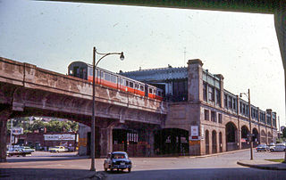
The Washington Street Elevated was an elevated segment of Boston's Massachusetts Bay Transportation Authority subway system, comprising the southern stretch of the Orange Line. It ran from Chinatown through the South End and Roxbury, ending in Forest Hills in Jamaica Plain, Boston.

Newtonville is one of the thirteen villages within the city of Newton in Middlesex County, Massachusetts, United States.

The 1767 Milestones are historic milestones located along the route of the Upper Boston Post Road between the cities of Boston and Springfield in Massachusetts. The 40 surviving milestones were added to the National Register of Historic Places in 1971. Massachusetts has a total of 129 surviving milestones including those along the upper Post Road. The stones are so named, despite having been placed in many different years, because of a 1767 directive of the Province of Massachusetts Bay that such stones be placed along major roadways. The state highway department was directed in 1960 to undertake their preservation. Many of them underwent a major restoration in 2018.

Eliot Burying Ground is a historic seventeenth-century graveyard at Eustis and Washington Streets in the Roxbury neighborhood of Boston, Massachusetts. It occupies a roughly triangular lot of 0.8 acres (0.32 ha).

The Dillaway School is an historic school at 16-20 Kenilworth Street in Boston, Massachusetts. The school was built in 1882 to a design by George Albert Clough, the city's first official architect, and is his only surviving school design in the city. The building was listed on the National Register of Historic Places in 1980, and included in the Roxbury Highlands Historic District in 1989. The building has been converted to residential use.

The Harvard Square Subway Kiosk is a historic kiosk and landmark located in Harvard Square in Cambridge, Massachusetts. It was built in 1928 as the new main headhouse for the previously opened Harvard Square subway station. After the station closed in 1981 for major renovations, the kiosk was moved slightly and renovated. The Out of Town News newsstand, which opened in 1955, occupied the kiosk from 1984 to 2019. As of 2019, the City of Cambridge plans to convert it for public use.

The Brookline Town Green Historic District encompasses the historic colonial heart of the town of Brookline, Massachusetts. Centered on a stretch of Walnut Street between Warren and Chestnut Streets, this area is where the town's first colonial meeting house and cemetery were laid out, and was its center of civic life until the early 19th century. The district was listed on the National Register of Historic Places in 1980.

The Roslindale Substation is a historic electrical substation building at 4228 Washington Street in the center of the Roslindale village of Boston, Massachusetts. The brick Classical Revival building was constructed in 1911 by the Boston Elevated Railway (BERy), a predecessor to today's MBTA. The monumental building is 80 feet (24 m) long, 50 feet (15 m) wide, and 46 feet (14 m) high. The building was designed by Robert S. Peabody of Peabody and Stearns, and built by Stone & Webster. The building was use by the Boston Elevated and its successors to provide AC to DC conversion for street cars until 1971. It is one of four substations built by the BERy to survive.
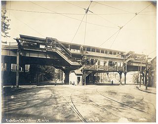
Egleston was a rapid transit station in Boston, Massachusetts. It served the Washington Street Elevated, part of the MBTA's Orange Line. It was located over Egleston Square at the intersection of Washington Street and Columbus Avenue in the Roxbury neighborhood. The station opened in November 1909, and closed in April 1987 when the Orange Line was rerouted to the west along the Southwest Corridor.

Fort Hill is a 0.4 square mile neighborhood and historic district of Roxbury, in Boston, Massachusetts. The approximate boundaries of Fort Hill are Malcolm X Boulevard on the north, Washington Street on the southeast, and Columbus Avenue on the southwest.

Pleasant Street was a station of the Boston Elevated Railway (BERy) located just outside the Pleasant Street incline in downtown Boston, Massachusetts. Opening along with the rest of the Main Line Elevated in June 1901, it served Main Line El trains from 1901 to 1908, temporarily replacing streetcar service through the Pleasant Street Incline. In 1908, with the completion of the Washington Street Tunnel, the elevated trains were rerouted through the new tunnel, and Pleasant Street station was closed; although streetcar service to North Station through the Pleasant Street Incline promptly resumed, the streetcars did not stop at Pleasant Street.

The Conductor's Building is a former Boston Elevated Railway (BERy) administrative building, located on Bennett Alley between Mount Auburn Street and Bennett Street near Harvard Square in Cambridge, Massachusetts. Built in 1912 as the headquarters of BERy's 7th Division, it is the only original building surviving from the construction of the Cambridge subway. After being renovated from 2014 to 2017 as part of an adjacent hotel project, the building was used as a restaurant from April 2017 to August 2018. Under the name Boston Elevated R.Y. Offices, it is a contributing property to the Harvard Square Historic District.

The Governor Shirley Square Historic District encompasses a cluster of civic, residential, and religious buildings at the junction of Dudley, Hampden, and Dunmore Streets in the Roxbury neighborhood of Boston, Massachusetts. Named for colonial governor William Shirley in 1913, the square was developed in the 1870s and 1880s as a major locus of civic development after the city of Roxbury was annexed to Boston in 1868. The district was listed on the National Register of Historic Places in 2016.


 Dudley and Warren Streets
 Palladio Hall
 Warren Street


