
The Metropolitan Subdivision is a railroad line owned and operated by CSX Transportation in Washington, D.C. and Maryland.The 53-mile line runs from Washington, D.C., northwest to Weverton, Maryland, along the former Metropolitan Branch of the Baltimore and Ohio Railroad.

The Fairfax Bridge is a steel-lattice three-hinged arch bridge spanning the Carbon River on State Route 165 in Pierce County, Washington. Previous to the construction of the bridge in 1921, the only route south to the area around Fairfax was by train. At a total cost of $80,000, the bridge's deck sits 250 feet (76 m) above the river. Being a single-lane bridge, vehicles must yield to oncoming traffic already on the bridge.

The Beverly Railroad Bridge is a historic railroad bridge that now carries hikers, bicyclists, and pedestrians over the Columbia River near Beverly, Washington, United States. It was constructed by the Chicago, Milwaukee, St. Paul and Pacific Railroad in 1909 during its Pacific Extension. In 1906, The Milwaukee Road began construction on its transcontinental rail line from Chicago, Illinois to Tacoma, Washington, which was completed three years later.

The Rosalia Railroad Bridge was built by the Chicago, Milwaukee, St. Paul and Pacific Railroad in 1915 to replace an earlier timber trestle. The bridge was designed as a concrete arch, unusual for a railroad bridge, because it crosses the Northern Pacific Railroad tracks, a state highway, and is visible from Steptoe Battlefield State Park. The railroad wanted an impressive-looking bridge. The viaduct consists of two spans, separated by an embankment. East of the 334-foot (102 m) embankment there is a 114-foot (35 m) span crossing over the Northern Pacific tracks. To the west is a 502-foot (153 m) span that crosses Pine Creek, railroad tracks, and the highway.
The Chicago, Milwaukee, St. Paul and Pacific Railroad Company Historic District consists of the historic right-of-way of the Chicago, Milwaukee, St. Paul and Pacific Railroad in the Bitterroot Mountains from East Portal, Montana, to the mouth of Loop Creek, Idaho, a distance of 14.5 miles (23.3 km). The district was once part of the railroad's mainline from Chicago, Illinois to Tacoma, Washington.
The Housatonic River Railroad Bridge is a historic bridge carrying Metro-North Railroad's New Haven Line trackage across the lower Housatonic River in the U.S. state of Connecticut. The bridge is also used by Amtrak for its Northeast Corridor services. It was listed on the National Register of Historic Places in 1987, which also refers to the bridge as the Devon Bridge. It is also referred to as the Devon Railroad Bridge by the state Department of Environmental Protection.
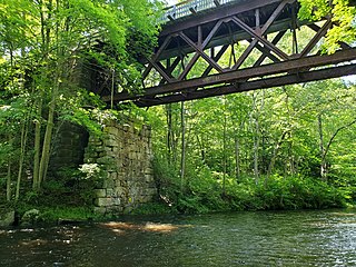
The Blackledge River Railroad Bridge is a Warren truss bridge that was built on the site of a c. 1870 railroad bridge. The original bridge was completed and opened by August 3, 1877. Likely built by the Colchester Railway Company, the bridge was part of the 3.59 miles (5.78 km) of track from Colchester, Connecticut, to Turnerville. The line was leased to the Boston and New York Air-Line Railroad and reported improvement in 1879 and a new 110-foot long (34 m) iron bridge by 1881. The line was leased to the New York, New Haven and Hartford Railroad in 1882. After dominating the region, the New York, New Haven and Hartford Railroad petitioned for changes to the Air Line and the approval came on July 7, 1911.

The Fink-Type Truss Bridge, also known as the Hamden Bridge, carried Hamden Road/River Road over the South Branch Raritan River, the border between Clinton Township and Franklin Township, at Hamden near the Allerton section of Hunterdon County, New Jersey. The bridge was built in 1857 by the Trenton Locomotive and Machine Manufacturing Company. It consisted of a single-span through truss 100 feet (30 m) long, 15 feet (4.6 m) wide, and 19 feet (5.8 m) high.

This is a list of the National Register of Historic Places listings in Seattle, Washington.

The Yale Bridge or Lewis River Bridge spans the Lewis River near Yale, Washington. It was built in 1932 by Cowlitz and Clark counties. The suspension bridge has a clear span of 300 feet (91 m), with a total length of 532 feet (162 m), replacing a previous steel truss bridge at the site. Construction of the Ariel Dam had created Lake Merwin with a water depth of 90 feet (27 m) at the site, requiring a new bridge that did not need to have support piers in the water. The road deck, stiffened by a steel Warren truss, is 50 feet (15 m) above the high water line of the reservoir.

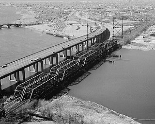
The Columbia River Bridge at Wenatchee, Washington, also known as the Old Wenatchee Bridge and W.T. Clark Pipeline Bridge was built by the Washington Bridge Company in 1908, primarily as a means to carry irrigation water pipelines across the Columbia River. It was the first road bridge over the Columbia south of Canada. The bridge is a pin-connected cantilever truss, 1,600 feet (490 m) long, with one 200-foot (61 m) Pratt truss between two 160-foot (49 m) cantilever arms, with 240-foot (73 m) side arms and a 60 feet (18 m) girder span. The bridge was purchased by the Washington highway department for $182,000 for highway use. As originally built, the bridge carried a 20.5-foot (6.2 m) wide timber roadway, with additional ability to carry a street railway. However, the east approach to the bridge was built at a 6% grade, limiting its potential.
Patton Bridge is a bridge located in Auburn, Washington listed on the National Register of Historic Places. The bridge spans the Green River near metropolitan Auburn, Washington. It was designed by bridge engineer and designer Homer M. Hadley. The combination of concrete and steel box girders employed in the bridge's represents a variation of the box girder bridge style. The Patton Bridge was the only structure built between 1941 and 1950, which exhibits this innovative modification of the box girder design.
The Goffstown Covered Railroad Bridge was a rare railroad covered bridge in Goffstown, New Hampshire. It was built in 1901 by the Boston and Maine Railroad, on the site of an earlier bridge built in 1850 by the New Hampshire Central Railroad, and carried its tracks across the Piscataquog River in the center of Goffstown. The bridge was listed on the National Register of Historic Places in 1975. It was destroyed by arson in 1976, as would later be the case with the Hillsborough Railroad Bridge in 1985.

The Gould's Mill Bridge is a historic Baltimore through truss bridge, carrying Paddock Street across the Black River in Springfield, Vermont. The bridge was built by the Boston Bridge Works Company in 1929 after major flooding in 1927, and is one of the state's few examples of a Baltimore truss. It was listed on the National Register of Historic Places in 2006.

The East Shoreham Covered Railroad Bridge is a historic covered bridge spanning the Lemon Fair River near East Shoreham, Vermont. Built in 1897 by the Rutland Railroad Company, it is the state's only surviving example of a wooden Howe truss railroad bridge. It was listed on the National Register of Historic Places in 1974.

The Railroad Street Bridge is a historic Pratt through truss bridge, carrying Railroad Street across the Lamoille River in Johnson, Vermont. It was built in 1928, after the state's devastating 1927 floods, and is one of its few surviving Pratt through truss bridges. It was listed on the National Register of Historic Places in 2007 as Bridge 6.

The Manning-Rye Covered Bridge, spanning the Palouse River near Colfax, Washington, was built around 1918. It was listed on the National Register of Historic Places in 1982. It has also been known as the Harpole Bridge.

The Conant Creek Pegram Truss Railroad Bridge, in Fremont County, Idaho near Grainville, Idaho and Ashton, Idaho, was built in 1894. It brought a railroad over the Conant Creek, 1 mile south of the junction of Squirrel Rd. and the old Ashton-Victor railroad spur tracks. It is a Pegram truss bridge, designed by George H. Pegram. It was listed on the National Register of Historic Places in 1997.
The Black River Bridge near Carrizo, Arizona was funded in 1911 and built in 1912. It was listed on the National Register of Historic Places in 1988. It spans the Black River, bringing an army road, now Indian Route 9, over the river from Fort Apache to the railroad at the former town of Rice, Arizona.
The Doty Bridge was a covered bridge located in Doty, Washington, United States. A replacement for an earlier bridge, it was previously listed on the National Register of Historic Places (NRHP) in 1982. The Doty Bridge was removed eight years later in 1990 after the structure was reported by the state as having been destroyed.


