
Dunstable is a town in Middlesex County, Massachusetts, United States. The population was 3,358 at the 2020 census.

The Amherst Central Business District is a historic district encompassing the heart of downtown Amherst, Massachusetts. Centered on the northern section of the long town common, the area has been the civic and commercial heart of the town since the 18th century. The district was listed on the National Register of Historic Places in 1991, and slightly enlarged in 2011.

The Lunenburg Historic District is a historic district encompassing the historic center of Lunenburg, Massachusetts. The district is centered on a stretch of Main Street which connects two triangular intersections. It includes many of the town's oldest buildings, including the c. 1724 Cushing House, and the c. 1730 Stillman Stone House. Three of the town's most significant institutional buildings were built before 1850: the town hall, the Congregational church, and the Methodist church. The district was added to the National Register of Historic Places in 1988.

The Brewster Old King's Highway Historic District is a historic district encompassing much of Massachusetts Route 6A and portions of some adjacent roads in Brewster, Massachusetts, which was known as the Old King's Highway during colonial times. The center of Brewster grew around the junction of the Old King's Highway and Harwich Road, with its first church built there in 1700, and a nearby burying ground established in 1707. The civic and commercial functions of the town were spread along the Old King's Highway through the 19th and into the early 20th century. This concentration of historic resources extends about 1.5 miles (2.4 km) west of the main junction, and about 1.2 miles (1.9 km) eastward.

The Upper Historic District is a historic district encompassing the historic center of Washington, Massachusetts. Centered on the junction of Washington Mountain Road and Branch Road, the town center flourished from the town's establishment in the 1750s until the center of the town's business moved closer to the newly lain railroad in the 1830s. The district includes the old town hall, cemetery, common, and pound, as well as a number of residences. A meeting house (church) and schoolhouse once stood in the area, but the 1792 church was destroyed by lightning in 1859, and the schoolhouse is no longer extant. The district was added to the National Register of Historic Places in 1987. It was listed as part of the Washington Multiple Property Submission (MPS).

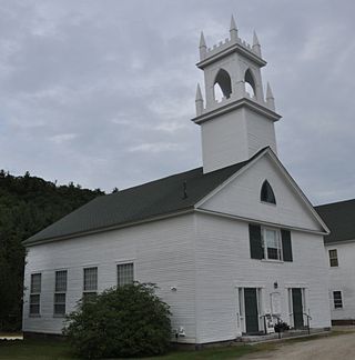
The West Granville Historic District is a historic district encompassing the center of West Granville, Massachusetts. The village is composed mainly of buildings form the late 18th and early 19th centuries, including an 18th-century church and 1830s academy building. The district was listed on the National Register of Historic Places in 1991.

Boxborough Old Town Center is a historic district encompassing the historic center of Boxborough, Massachusetts. It consists of a cluster of properties that lie primarily along Hill Road, extending from point a short way north of its junction with Schoolhouse Lane to a bend in road just south Middle Street. The 52 contributing properties range in date from the 1770s to the early 20th century, spanning much of the town's history. The town was bypassed by significant economic development in the 19th century, and has retained much of its rural charm, despite growing suburbanization in the second half of the 20th century. This particular area constituted the civic heart of the town until about 1900, when the current town hall was built in a more central location. It includes the town's oldest cemetery, adjacent to the site of its first meeting house. It also has one the town's five surviving one-room schoolhouses, including a privy which was used into the mid-20th century. The district was listed on the National Register of Historic Places in 2006.
The Arlington Center Historic District includes the civic and commercial heart of Arlington, Massachusetts. It runs along the town's main commercial district, Massachusetts Avenue, from Jason Street to Franklin Street, and includes adjacent 19th- and early 20th-century residential areas roughly bounded by Jason Street, Pleasant Street, and Gray Street. The district was listed on the National Register of Historic Places in 1974.

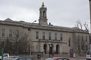
The Nashville Historic District in Nashua, New Hampshire is a historic district that was listed on the National Register of Historic Places (NRHP) in 1984. It encompasses an area just north of downtown Nashua, roughly centered on the junction of Concord, Amherst, and Main streets. Its southern bound is the Nashua River and Railroad Square, its eastern bounds are Railroad Square, Clinton, Lock, Orange, and Concord streets, its northern bound is Mount Pleasant Street, and its western boundary is Abbott, Amherst, Concord, and Main streets between the northern and southern bounds.

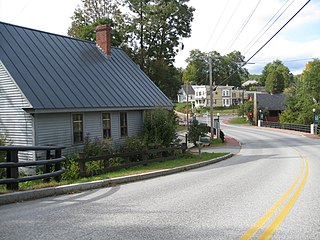
The Hollis Village Historic District encompasses the historic village center of Hollis, New Hampshire. The district is centered on Monument Square, which connects Main Street to Depot Street and Broad Street. It covers about 400 acres (160 ha), and extends along all three of those roads for some distance, and includes properties on Silver Lake Road and Ash Street. Most of the buildings in the district are residential or agricultural in use, and date before the turn of the 20th century; the oldest buildings date to the mid-18th century. The "Always Ready Engine House", which occupies a triangular parcel at the western end of Monument Square, was built in 1859, and is the town's oldest municipal building. Its most architecturally sophisticated building is the town hall, built in 1887 to a design by William M. Butterfield of Manchester. The district represents the growth of a mainly agricultural community over a 200-year period. The district was listed on the National Register of Historic Places in 2001.

The Middlefield Center Historic District encompasses the historic village center of Middlefield, Massachusetts. It is centered on the junction of Skyline Trail, the main north-south road, with Bell and Town Hill Roads. The district was listed on the National Register of Historic Places in 2012.

The East Andover Village Center Historic District encompasses the historic village center of East Andover, New Hampshire, United States. The 2.2-acre (0.89 ha) district includes a cemetery and three buildings: the Andover Congregational Church, the Highland Lake Grange Hall, and the East Andover Schoolhouse. It is located at the corner of New Hampshire Route 11 and Chase Hill Road. The district is unified by the appearance of the three buildings, and their styling, which is predominantly vernacular 19th century.
The Enfield Village Historic District encompasses the historic 19th century village center of Enfield, New Hampshire. The district was listed on the National Register of Historic Places in 2010. Multiple buildings of the district were added to the New Hampshire State Register of Historic Places in 2012.
The Bedford Town Hall is located at 70 Bedford Center Road in Bedford, New Hampshire. Built in 1910, it is a prominent early work of Chase R. Whitcher, a noted architect of northern New England in the early 20th century. The building is the third town hall to stand on this site, and was listed on the National Register of Historic Places in 1984.

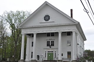
The Wakefield Village Historic District encompasses the historic village center of Wakefield, New Hampshire. It is centered at the junction of New Hampshire Route 153 and Mountain Laurel Road, which was historically the major north–south route in Carroll County. The district consists mainly of residential properties dating from the 18th to early 20th centuries, and also includes the 1836 town hall, public library¸ Grange Hall, and a one-room schoolhouse that now houses the local historical society. The district was listed on the National Register of Historic Places in 1984.
The Salem Common Historic District encompasses the early colonial center of Salem, New Hampshire. The district dates to the earliest period of settlement of Salem, and includes the historic common, old town hall, fire station, and library. The town hall was built in 1738 and extensively altered in 1838 and 1899; it served as a place for town meetings until 1958. The district was listed on the National Register of Historic Places in 2011.

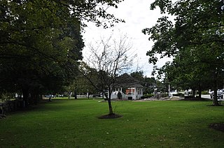
The Town Center Historic District encompasses the historic village center of South Hampton, New Hampshire. Centered around the Barnard Green, the town common, on New Hampshire Route 107A, it includes architectural reminders of the town's growth and change over time. The district was listed on the National Register of Historic Places in 1983.
The Washington Common Historic District encompasses a cluster of three civic buildings and the town common in the center of Washington, New Hampshire. The town common began as a 2-acre (0.81 ha) parcel acquired in 1787, and the current town hall followed in 1789. It is a two-story wood-frame building which originally served as both a civic and religious meeting house. The adjacent Gothic Revival Congregational Church was built in 1840. The third structure is the Schoolhouse, a 2+1⁄2-story two-room school built in 1883. The district was listed on the National Register of Historic Places in 1986.

The Plainfield Center Historic District encompasses the historic rural village center of Plainfield, Massachusetts. The district is centered on a stretch of Main Street, between Church Lane and Central Street, and includes the town's oldest surviving houses, and its congregational church, set on the site of its first colonial-era meeting house, as well as the town hall (1847) and library (1925). The district was listed on the National Register of Historic Places in 2015.

Barkhamsted Center Historic District is a historic district at the intersection of Center Hill Road and Old Town Hall Road in Barkhamsted, Connecticut. It encompasses the surviving elements of Barkhamsted's original town center, most of which was flooded by the creation of Barkhamsted Reservoir in the early 20th century. The district was listed on the National Register of Historic Places in 1999.


