Durrow, County Offaly (civil parish)

Last updated

Durrow
Darú
Civil parish
Ireland adm location map.svg
Red pog.svg
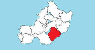
Durrow
Location of Durrow within County Offaly in the Republic of Ireland
Coordinates: 53°19′14″N7°31′43″W / 53.32056°N 7.52861°W / 53.32056; -7.52861 Coordinates: 53°19′14″N7°31′43″W / 53.32056°N 7.52861°W / 53.32056; -7.52861
Country Flag of Ireland.svg Republic of Ireland
Province Leinster
County County Offaly
Irish grid reference N341320

Durrow (Irish : Darú) [1] is a civil parish in County Offaly, Ireland. It is located about 5.52 kilometres (3 mi) north–north–west of Tullamore.

Irish language Goidelic (Gaelic) language spoken in Ireland and by Irish people

Irish is a Goidelic (Gaelic) language originating in Ireland and historically spoken by the Irish people. Irish is spoken as a first language in substantial areas of counties Galway, Kerry, Cork and Donegal, smaller areas of Waterford, Mayo and Meath, and a few other locations, and as a second language by a larger group of non-habitual speakers across the country.

Civil parishes in Ireland administrative division of Ireland

Civil parishes are units of territory in the island of Ireland that have their origins in old Gaelic territorial divisions. They were adopted by the Anglo-Norman Lordship of Ireland and then by the Elizabethan Kingdom of Ireland, and were formalised as land divisions at the time of the Plantations of Ireland. They no longer correspond to the boundaries of Roman Catholic or Church of Ireland parishes, which are generally larger. Their use as administrative units was gradually replaced by Poor Law Divisions in the 19th century, although they were not formally abolished. Today they are still sometimes used for legal purposes.

County Offaly County in the Republic of Ireland

County Offaly is a county in Ireland. It is part of the Midlands Region and is also located in the province of Leinster. It is named after the ancient Kingdom of Uí Failghe and was formerly known as King's County. Offaly County Council is the local authority for the county. The county population was 77,961 at the 2016 census.

Durrow is one of 4 civil parishes in the barony of Ballycowan in the Province of Leinster. The civil parish covers 7,526.4 acres (30.458 km2). It is contiguous with the remainder of the Durrow civil parish, which is in County Westmeath.

Barony (Ireland) historical subdivision of a county of Ireland

In Ireland, a barony is a historical subdivision of a county, analogous to the hundreds into which the counties of England were divided. Baronies were created during the Tudor reconquest of Ireland, replacing the earlier cantreds formed after the original Norman invasion. Some early baronies were later subdivided into half baronies with the same standing as full baronies.

Ballycowan (barony) Barony in Offaly, Republic of Ireland

Ballycowan or Ballycowen is a barony in County Offaly, Republic of Ireland.

Provinces of Ireland political divisions of the Republic of Ireland

Since the early 17th-century there have been four Provinces of Ireland: Connacht, Leinster, Munster and Ulster. The Irish word for this territorial division, cúige, meaning "fifth part", indicates that there were once five, however in the medieval period there were more. The number of provinces and their delimitation fluctuated until 1610 when they were permanently set by the English administration of James I. The provinces of Ireland no longer serve administrative or political purposes, but function as historical and cultural entities.

Durrow civil parish, County Offaly comprises the small village of Durrow and 21 townlands: Acantha, Aghancarnan, Ashfield, Balleek, Balleek Beg, Ballybought, Ballycallaghan, Ballynamona, Cartron, Coleraine, Coniker, Coolnahely, Culleen, Doory, Durrow Demesne, Gormagh, Kilclare, Kildangan, Loughaun, Lug and Tara.

Durrow, County Offaly Town in Leinster, Ireland

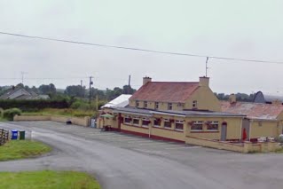
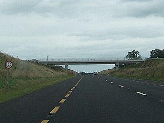
Durrow is a small rural village in County Offaly, Ireland. Durrow is located on the N52 off the N6 road between Kilbeggan and Tullamore.

The neighbouring civil parishes are: Ardnurcher or Horseleap (County Westmeath) to the north, Ballycommon to the east, Kilbride to the south, Rahan to the west and Kilbride to the west and north. [2] [3]

Ardnurcher, County Westmeath (civil parish) Civil parish in Leinster, Republic of Ireland

Ardnurcher is a civil parish in County Westmeath, Ireland. It is located about 19.89 kilometres (12 mi) south–west of Mullingar.

County Westmeath County in the Republic of Ireland

County Westmeath is a county in Ireland. It is in the province of Leinster and is part of the Midlands Region. It originally formed part of the historic Kingdom of Meath. It was named Mide because the kingdom was located in the geographical centre of Ireland. Westmeath County Council is the administrative body for the county, and the county town is Mullingar. At the 2016 census, the population of the county was 88,770.

Related Research Articles

Moycashel Barony in Leinster, Ireland

Moycashel, previously the barony of Rossaughe, before that, Delamares country, is a barony in south County Westmeath, in the Republic of Ireland. It was formed by 1542. It is bordered by three other baronies: Clonlonan to the west, Rathconrath to the north, Moyashel and Magheradernon to the north-east and Fartullagh to the west. The largest population centre is Kilbeggan.

Rahugh

Rahugh or Ráith Aeda Meic Bric is an early Christian site founded by Áed mac Bricc in the 6th century, inside a ráth or ringfort. The site, located about 8 km north of Tullamore along the L1024.

Clonlonan Barony in Leinster, Ireland

Clonlonan is a barony in south–west County Westmeath, Ireland. It was formed by 1672. It is bordered by County Offaly to the south and a small part of County Roscommon at Long Island on the River Shannon to the west. It also borders four other Westmeath baronies: Kilkenny West and Rathconrath, Moycashel and Brawny. The largest centre of population in the barony is the town of Moate.

Fartullagh Barony in Leinster, Ireland

Fartullagh, previously Tyrrells country, is a barony in south–east County Westmeath, in the Republic of Ireland. It was formed by 1542. It is bordered by County Offaly to the south and three other baronies: Moycashel, Moyashel and Magheradernon and Farbill.

Aghamore is a village in County Leitrim, Ireland

Pass of Kilbride (civil parish) Civil parish in Leinster, Republic of Ireland

Pass of Kilbride is a civil parish in County Westmeath, Ireland. It is located about 11.97 kilometres (7 mi) south‑south‑east of Mullingar.

Moylisker Civil parish in Leinster, Republic of Ireland

Moylisker is a civil parish in County Westmeath, Ireland. It is located about 6.14 kilometres (4 mi) south of Mullingar.

Enniscoffey (civil parish) Civil parish in Leinster, Republic of Ireland

Enniscoffey is a civil parish in County Westmeath, Ireland. It is located about 8.5 kilometres (5 mi) south–south–east of Mullingar.

Castlelost (civil parish) Civil parish in Leinster, Republic of Ireland

Castlelost is a civil parish in County Westmeath, Ireland. It is located about 12.81 kilometres (8 mi) south of Mullingar.

Kilbride, County Westmeath (civil parish) Civil parish in Leinster, Republic of Ireland

Kilbride is a civil parish in County Westmeath, Ireland. It is located about 9.26 kilometres (6 mi) south of Mullingar.

Carrick, County Westmeath (civil parish) Civil parish in Leinster, Republic of Ireland

Carrick is a civil parish in County Westmeath, Ireland. It is located about 8.47 kilometres (5 mi) south of Mullingar.

Kilbeggan (civil parish) Civil parish in Leinster, Republic of Ireland

Kilbeggan is a civil parish in County Westmeath, Ireland. It is located about 19.86 kilometres (12 mi) south–south–west of Mullingar.

Kilcumreragh Civil parish in Leinster, Republic of Ireland

Kilcumreragh is a civil parish which spans the counties of Westmeath and Offaly in Ireland. It is located about 23.23 kilometres (14 mi) west–south–west of Mullingar and 18.28 kilometres (11 mi) north–north–west of Tullamore.

Durrow, County Westmeath (civil parish) Civil parish in Leinster, Republic of Ireland

Durrow is a civil parish in County Westmeath, Ireland. It is located about 22.89 kilometres (14 mi) south–south–west of Mullingar.

Rahugh (civil parish) Civil parish in Leinster, Republic of Ireland

Rahugh is a civil parish in County Westmeath, Ireland. It is located about 20 kilometres (12 mi) south–south–west of Mullingar.

Ardnurcher, County Offaly (civil parish) Civil parish in Leinster, Republic of Ireland

Ardnurcher is a civil parish in County Offaly, Ireland. It is located about 13.74 kilometres (9 mi) north–north–west of Tullamore.

Foyran Civil parish in Leinster, Republic of Ireland

Foyran, is a civil parish in County Westmeath, Ireland. It is located about 27.27 kilometres (17 mi) north of Mullingar.

Kilmanaghan (civil parish) Civil parish in Leinster, Republic of Ireland

Kilmanaghan is a civil parish which spans the counties of Offaly and Westmeath in Ireland. It is located about 27.76 kilometres (17 mi) south–west of Mullingar and 17.52 kilometres (11 mi) north–west of Tullamore.

Kilcleagh (civil parish) Civil parish in Leinster, Republic of Ireland

Kilcleagh is a civil parish in County Westmeath, Ireland. It is located about 34.79 kilometres (22 mi) west–south–west of Mullingar.

References

  1. Durrow civil parish, County Offaly The Placenames Database of Ireland. Retrieved on 15 July 2015.
  2. Durrow civil parish, County Offaly townlands.ie Retrieved on 15 July 2015.
  3. Durrow civil parish, County Offaly The IreAtlas Townland Data Base. Retrieved on 15 July 2015.