East Boston, nicknamed Eastie, is a neighborhood of Boston, Massachusetts, United States, which was annexed by the city of Boston in 1637. Neighboring communities include Winthrop, Revere, and Chelsea. It is separated from the Boston neighborhood of Charlestown and downtown Boston by Boston Harbor. The footprint of the East Boston neighborhood as it is known today was created in the 1940s by connecting five of the inner harbor islands using land fill. Logan International Airport is located in East Boston, connecting Boston to domestic and international locations.

Beacon Hill is a historic neighborhood in Boston, Massachusetts, United States. It is also the location of the Massachusetts State House. The term "Beacon Hill" is used locally as a metonym to refer to the state government or the legislature itself, much like Washington, D.C.'s Capitol Hill does at the federal level.

Chestnut Hill is a wealthy New England village located six miles (10 km) west of downtown Boston, Massachusetts, United States. It is best known for being home to Boston College and a section of the Boston Marathon route. Like all Massachusetts villages, Chestnut Hill is not an incorporated municipal entity. It is located partially in Brookline in Norfolk County; partially in the city of Boston in Suffolk County, and partially in the city of Newton in Middlesex County. Chestnut Hill's borders are defined by the 02467 ZIP Code. The name refers to several small hills that overlook the 135-acre Chestnut Hill Reservoir rather than one particular hill.

Mission Hill is a 3⁄4 square mile, primarily residential neighborhood of Boston, bordered by Roxbury, Jamaica Plain and Fenway-Kenmore and the town of Brookline. The neighborhood has two main streets, namely Tremont Street and Huntington Avenue. It is served by several stations on the MBTA's Green Line E branch, as well as Roxbury Crossing station on the Orange Line.

Spring Hill is a ridge in the central part of the city of Somerville, Massachusetts, United States, and the residential neighborhood that sits atop it. It runs northwest to southeast, roughly bounded by Highland Avenue, Somerville Avenue, Elm Street, and Willow Avenue. Summer Street runs along the hill's crest.

Sugar Hill is a National Historic District in the Harlem and Hamilton Heights neighborhoods of Manhattan, New York City, bounded by West 155th Street to the north, West 145th Street to the south, Edgecombe Avenue to the east, and Amsterdam Avenue to the west. The equivalent New York City Historic Districts are:

Forest Hills is a part of the Jamaica Plain neighborhood of Boston, Massachusetts, United States. Forest Hills is characterized by hilly terrain and wooded areas within and adjacent to its borders. In general, the area slopes upward from Hyde Park Ave and downward from Walk Hill Street.

The Sumner Hill Historic District encompasses a predominantly residential area of high-quality late 19th-century residences in the Jamaica Plain neighborhood of Boston, Massachusetts. It is roughly bounded by Seaverns Avenue, Everett Street, Carolina Avenue, and Newbern Street just east of the neighborhoods commercial Centre Street area. The district features Second Empire, Italianate, and Queen Anne style architecture, and was listed on the National Register of Historic Places in 1987.

The Trinity Neighborhood House is a historic brick townhouse at 406 Meridian Street located in the Eagle Hill section of East Boston, Massachusetts.

The Farnum's Gate Historic District is a historic district encompassing a neighborhood of Blackstone, Massachusetts, associated with the locally prominent Farnum family. The area, on Main Street roughly between Austin Street and the St. Paul's Bridge, includes a number of homes built in the 1840s by prominent local industrialists, during a period of prosperity in the Blackstone River valley. The district was added to the National Register of Historic Places in 1995.
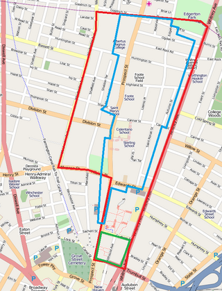
Prospect Hill is a neighborhood of the city of New Haven, Connecticut located in the north central portion of the city, directly north of Downtown New Haven. The neighborhood contains residences, institutional buildings of Albertus Magnus College and a portion of the main campus of Yale University, including the Science Hill area, the Hillhouse Avenue area and the Yale Peabody Museum. The City of New Haven defines the neighborhood to be the region bounded by the town of Hamden in the north, Winchester Avenue in the west, Munson Street/Hillside Place/Prospect Street in the southwest, Trumbull Street in the south, and Whitney Avenue in the east. Prospect Street is the main thoroughfare through the neighborhood.
The Prospect Hill Historic District is an irregularly-shaped 185-acre (75 ha) historic district in New Haven, Connecticut. The district encompasses most of the residential portion of the Prospect Hill neighborhood.
The North Bedford Historic District is a historic district roughly bounded by Summer, Parker, Pleasant and Kempton Streets in New Bedford, Massachusetts. It encompasses a predominantly residential neighborhood north of downtown New Bedford which was developed primarily in the mid 19th-century. It features a variety of worker housing of the period, as well as a number of higher quality houses built by businessmen. The district was added to the National Register of Historic Places in 1979.

Buttonwood Park Historic District is a historic district on Kempton Street, Rockdale Avenue, Hawthorne Street and Brownell Avenue in New Bedford, Massachusetts. Its focal point is Buttonwood Park, a 97-acre (39 ha) municipal park planned by Charles Eliot in the 1890s, and part of its surrounding neighborhood. The neighborhood was developed in the first decades of the 20th century as a complement to the park, and contains a fine selection of Colonial Revival and Craftsman style houses. The district was added to the National Register of Historic Places in 2000.

The Freeman's Grove Historic District is a residential historic district in North Adams, Massachusetts. It encompasses a neighborhood north of the city center that is a well-preserved instance of a working class area developed during its industrial heyday in the late 19th century. It includes the Chase Hill Estate as well as all the houses on Chase Avenue, Bracewell Street, Hall Street and several smaller streets adjacent to those. It is roughly bounded by Liberty Street, Eagle Street, Bracewell Avenues and Houghton Street. The district was listed on the National Register of Historic Places in 1985.
The Spring Hill Historic District is a historic district roughly bounded by Summer, Central, Atherton, and Spring Streets in the Spring Hill area of Somerville, Massachusetts. The district encompasses the city's best-preserved residential subdivision from the mid-19th century, with later infill construction in the late 19th and early 20th centuries. The district was listed on the National Register of Historic Places in 1989.

There are nine historic districts in Meridian, Mississippi. Each of these districts is listed on the National Register of Historic Places. One district, Meridian Downtown Historic District, is a combination of two older districts, Meridian Urban Center Historic District and Union Station Historic District. Many architectural styles are present in the districts, most from the late 19th century and early 20th century, including Queen Anne, Colonial Revival, Italianate, Art Deco, Late Victorian, and Bungalow.
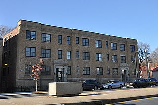
The Almont Apartments are historic apartment houses at 1439-43 and 1447-51 Blue Hill Avenue in the Mattapan neighborhood of Boston, Massachusetts. Built in 1926, they are well-preserved examples of Colonial Revival architecture, built during a period of growth fueled by the city's expanding streetcar network. The apartments were listed on the National Register of Historic Places in 2014.
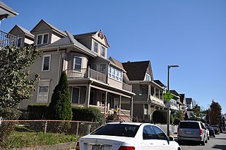
The Esmond Street Historic District is a historic district encompassing a small residential area in the Dorchester neighborhood of Boston, Massachusetts. Centered on a stretch of Esmond Street, the area was developed between 1884 and 1928, and includes a fine sample of Colonial Revival and Queen Anne architecture. The district was listed on the National Register of Historic Places in 2018.

The Charlotte Street-Esmond Street Historic District is a historic district encompassing a residential subdivision in the Dorchester neighborhood of Boston, Massachusetts. Centered on Charlotte and Esmond Streets, the area was developed in the early 20th century following the arrival of electrified street cars on nearby Blue Hill Avenue. The district was listed on the National Register of Historic Places in 2022.