
Massachusetts Avenue is a major diagonal transverse road in Washington, D.C., and the Massachusetts Avenue Historic District is a historic district that includes part of it.
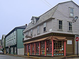
The Newport Historic District is a historic district that covers 250 acres in the center of Newport in the U.S. state of Rhode Island. It was designated a National Historic Landmark (NHL) in 1968 due to its extensive and well-preserved assortment of intact colonial buildings dating from the early and mid-18th century. Six of those buildings are themselves NHLs in their own right, including the city's oldest house and the former meeting place of the colonial and state legislatures. Newer and modern buildings coexist with the historic structures.

The Religious Structures of Woodward Avenue Thematic Resource (TR) is a multiple property submission to the National Register of Historic Places which was approved on August 3, 1982. The structures are located on Woodward Avenue in the cities of Detroit and Highland Park, Michigan.

Mount Pleasant Historic District is a historic district encompassing a cluster of well-preserved 19th-century residential buildings on Forest Street and Mount Pleasant Avenue in the Roxbury neighborhood of Boston, Massachusetts. First developed in 1833, it was one Roxbury's first speculative residential subdivision developments. The district features Greek Revival, Italianate, and Romanesque architecture, and was added to the National Register of Historic Places in 1989.

This is a list of the National Register of Historic Places listings in Detroit, Michigan.

The Central New Bedford Historic District is one of nine historic districts in New Bedford, Massachusetts, United States. The district encompasses the city's central business district, built up during the time in the late 19th century when textiles had replaced whaling as the city's main industry. It is a 29-acre (12 ha) rectangular area bounded by Acushnet Avenue and the older New Bedford Historic District on the east, School Street to the south, Middle Street on the north and 6th Street in the west. It was added to the National Register of Historic Places in 1980.

The Spencer Town Center Historic District encompasses the historic downtown of Spencer, Massachusetts. When first listed on the National Register of Historic Places in 1986, the district covered 250 acres (100 ha) centered on Main Street between High and North Streets. A major expansion, the East Main Street – Cherry Street Historic District, added 45 acres (18 ha) of a predominantly residential area east of the center. The district was expanded twice in 2003, adding residential areas along Grove, Prouty, Pleasant, High, and Main Streets, and industrial areas on Cherry, Wall, and Mechanic Streets, as well as Luther Hill Park. The main period of historic interest is the peak period of Spencer's industrial history in the last quarter of the 19th century, although there are a significant number of properties that predate this period.

The Cranesville Historic District is a historic district in Dalton, Massachusetts, centered on the business and residential properties associated with the papermaker Crane and Company. The district, centered on Main Street west of the town civic center, was added to the National Register of Historic Places in 2005.

The South Lee Historic District encompasses the historic portion of the village of South Lee in Lee, Massachusetts. Extending mainly along Massachusetts Route 102 between Fairview Street and the Stockbridge town line, the village is a well-preserved 19th-century mill village, with fine Federal and Greek Revival buildings and a later 19th-century paper mill. It was listed on the National Register of Historic Places in 1999.

The Central Gloucester Historic District encompasses the historic commercial, civic, and residential core of the fishing community of Gloucester, Massachusetts. Now largely defined by 19th century architectural trends, it includes the city's commercial downtown, its civic heart on Dale and Prospect Streets, and some adjacent residential areas. It was added to the National Register of Historic Places in 1982.
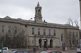
The Arlington Center Historic District includes the civic and commercial heart of Arlington, Massachusetts. It runs along the town's main commercial district, Massachusetts Avenue, from Jason Street to Franklin Street, and includes adjacent 19th- and early 20th-century residential areas roughly bounded by Jason Street, Pleasant Street, and Gray Street. The district was listed on the National Register of Historic Places in 1974.

Highland Heights–Stevens' Subdivision Historic District is a residential historic district located in Highland Park, Michigan along five east-west streets: Farrand Park, McLean Street, Colorado Street, Rhode Island Street, and Massachusetts Street, between Woodward Avenue on the west and Oakland Avenue on the east. The district was listed on the National Register of Historic Places in 1988.

The Nobility Hill Historic District is a residential historic district roughly bounded by Chestnut and Maple Streets and Cedar Avenue in Stoneham, Massachusetts. The district includes a number of high quality houses representing a cross section of fashionable housing built between 1860 and 1920. It was added to the National Register of Historic Places in 1990.
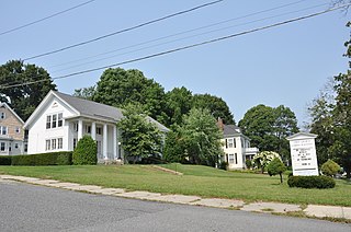
The West Main Street Historic District of Marlborough, Massachusetts encompasses a residential area west of the city center. It extends along West Main Street from Mechanic Street to Gibbon Street, along Pleasant Street from West Main to Lincoln Street, and also includes short pieces of Witherbee and Winthrop Streets abutting West Main. Most of the buildings in the district are houses built between 1820 and 1930, the period of the city's growth as an industrial center. The 15-acre (6.1 ha) district includes 77 properties, all but two of which contribute to its historic significance. The district was listed on the National Register of Historic Places in 2001.

Trowbridge Square Historic District, originally known as Village of Spireworth and Mount Pleasant, is a well-preserved 19th-century neighborhood in the Hill section of New Haven, Connecticut. Roughly bounded by Columbus, Howard, and Union Avenues, and Church Street on the east, the area was laid out in 1830 and developed as a working-class neighborhood. It retains its historic streetscape, and many original buildings, representing modest versions of a diversity of mid-to-late 19th century styles. The district was listed on the National Register of Historic Places in 1985.
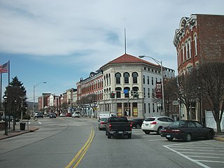
The Downtown Ossining Historic District is located at the central crossroads of Ossining, New York, United States, and the village's traditional business district known as the Crescent. Among its many late 19th- and early 20th-century commercial buildings are many of the village's major landmarks—three bank buildings, four churches, its village hall, former post office and high school. It was recognized as a historic district in 1989 and listed on the National Register of Historic Places, as one of the few downtowns in Westchester County with its social and historical development intact.

Mount Vernon Triangle is a neighborhood and community improvement district in the northwest quadrant of Washington, D.C. The neighborhood is located adjacent to Mount Vernon Square. Originally a working-class neighborhood established in the 19th century, present-day Mount Vernon Triangle experienced a decline in the mid-20th century as it transitioned from residential to commercial and industrial use.

The St. Johnsbury Historic District encompasses much of the historic civic and commercial center of St. Johnsbury, Vermont. Representing a significant expansion of the Railroad Street Historic District and the St. Johnsbury Main Street Historic District, it captures the historical tension and competition between Main Street and Railroad Street for primacy as the town's most important civic and commercial areas. The district was listed on the National Register of Historic Places in 1980.

The St. Johnsbury Main Street Historic District encompasses the historic civic and cultural center of the town of St. Johnsbury, Vermont. Organized along the town's Main Street, it includes high-quality architecture spanning the 19th and early 20th centuries, and includes the National Historic Landmark St. Johnsbury Athenaeum. Many of the district's buildings were designed by Lambert Packard, a prominent local architect. The district was listed on the National Register of Historic Places in 1975, and was enlarged slightly in 1976. It was subsumed into the larger St. Johnsbury Historic District in 1980.
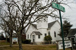
The South Chatham Village Historic District is a historic district encompassing much of the linear village of South Chatham in Chatham, Massachusetts. Extending eastward from the Harwich town line along Main Street, the district developed in the 18th and 19th centuries as a maritime and farming village. The district was listed on the National Register of Historic Places in 2022.


