The Eastern Neisse,[1] also known by its Polish name of Nysa Kłodzka (German: Glatzer Neiße, Czech: Kladská Nisa), is a river in southwestern Poland, a left tributary of the Oder, with a length of 188km (21st longest) and a basin area of 4,570km2 (3,742 in Poland).[2]
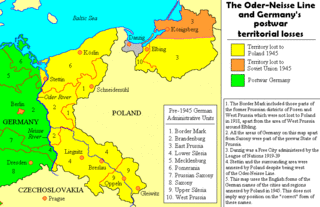
Prior to World War II it was part of Germany. During the Yalta Conference it was discussed by the Western Allies as one possible line of the western Polish border. Attempts were made to negotiate a compromise with the Soviets on the new Polish-German frontier; it was suggested that the Eastern Neisse be made the line of demarcation. This would have meant that (East) Germany could have retained approximately half of Silesia, including most of Wrocław (formerly Breslau). However the Soviets rejected the suggestion at the Potsdam Conference and insisted that the southern boundary between Germany and Poland be drawn further west, at the Lusatian Neisse,[3][1] in some way reintroducing the border to the place from the beginnings of Polish statehood, i.e. west of Legnica Town, important for Bolesław IV the Curly and Henry the Bearded, two Polish Princepses.[4][5]
Floods
The Eastern Neisse originates in the Králický Sněžník Mountains of the Sudetes, near the border with the Czech Republic. It is partially regulated. The river has often burst its banks and flooded nearby towns, at times destroying them completely. Town chronicles from Kłodzko mention floods in the following years:
Until 1945, these communities were situated on German territory and largely populated by Germans before they were driven out at the end of the Second World War. German names are indicated in italics.
Silesia is a historical region of Central Europe that lies mostly within Poland, with small parts in the Czech Republic and Germany. Its area is approximately 40,000 km2 (15,400 sq mi), and the population is estimated at 8,000,000. Silesia is split into two main subregions, Lower Silesia in the west and Upper Silesia in the east. Silesia has a diverse culture, including architecture, costumes, cuisine, traditions, and the Silesian language. The largest city of the region is Wrocław.
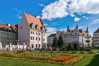
Nysa is a city in southwestern Poland on the Eastern Neisse river, situated in the Opole Voivodeship. With 43,849 inhabitants (2019), it is the capital of Nysa County. It comprises the urban portion of the surrounding Gmina Nysa. Historically the city was part of Upper Silesia.
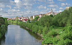
Kłodzko is a historic town in south-western Poland, in the region of Lower Silesia. It is situated in the centre of the Kłodzko Valley, on the Eastern Neisse river.
The Lusatian Neisse, or Western Neisse, is a 252-kilometre (157 mi) river in northern Central Europe. It rises in the Jizera Mountains, near Nová Ves nad Nisou, at the Czech border becoming the Polish–German border for its remaining 197 kilometres (122 mi), to flow into the similarly northward-flowing Oder from the left.
Nysa may refer to:
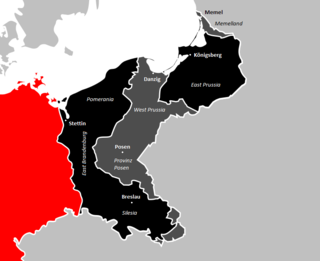
In present-day Germany, the former eastern territories of Germany refer to those territories east of the current eastern border of Germany, i.e. the Oder–Neisse line, which historically had been considered German and which were annexed by Poland and the Soviet Union after World War II. In contrast to the lands awarded to the restored Polish state by the Treaty of Versailles after World War I, the German territories lost with the post-World War II Potsdam Agreement were either almost exclusively inhabited by Germans before 1945, mixed German–Polish with a German majority, or mixed German–Czech with a German majority (Glatz). Virtually the entire German population of the territories that did not flee voluntarily in the face of the Red Army advance of 1945, was violently expelled to Germany, with their possessions being forcibly expropriated.
Lądek-Zdrój, known in English as Landek, is a spa town situated in Kłodzko County, Lower Silesian Voivodeship, southwestern Poland. It is the seat of the administrative district (gmina) called Gmina Lądek-Zdrój, close to the Czech border. As of 2019, the town has a population of 5,572.
Bystrzyca Kłodzka is a historic town in Kłodzko County, in Lower Silesian Voivodeship in southwestern Poland. It is the administrative seat of Gmina Bystrzyca Kłodzka. As of December 2021, the town has a population of 9,773. The old town of Bystrzyca is famous for its many historical buildings and is a popular tourist destination.
Bardo is a historical town in Ząbkowice Śląskie County, Lower Silesian Voivodeship, in south-western Poland. It is the seat of the administrative district (gmina) called Gmina Bardo.
Lower Lusatia is a historical region in Central Europe, stretching from the southeast of the German state of Brandenburg to the southwest of Lubusz Voivodeship in Poland. Like adjacent Upper Lusatia in the south, Lower Lusatia is a settlement area of the West Slavic Sorbs whose endangered Lower Sorbian language is related to Upper Sorbian and Polish.
Upper Lusatia is a historical region in Germany and Poland. Along with Lower Lusatia to the north, it makes up the region of Lusatia, named after the Slavic Lusici tribe. Both parts of Lusatia are home to the West Slavic minority group of the Sorbs.
The Lusatian Neisse is a river in Central Europe.
Lower Silesia is a historical and geographical region mostly located in Poland with small portions in the Czech Republic and Germany. It is the western part of the region of Silesia. Its largest city is Wrocław.
The Central Sudetes are the central part of the Sudetes mountain range on the border of the Czech Republic and Poland. They stretch from the Nysa Kłodzka River and the Kłodzko Valley in the east to the upper Bóbr in the west.
Paczków is a town in Nysa County, Opole Voivodeship, in southern Poland, with 7,460 inhabitants (2019). It is one of the few towns in Europe in which medieval fortifications have been almost completely preserved. Located in the southeastern outskirts of the historical province of Lower Silesia, along the medieval road from Lesser Poland to Klodzko Valley and Prague, Paczków is called "Polish Carcassonne", thanks to its well-preserved medieval fortifications. However, while the famous French Carcassonne is a 19th-century reconstruction, all historic buildings of Paczków are authentic.
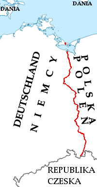
The Oder–Neisse line is an unofficial term for the modern border between Germany and Poland. The line generally follows the Oder and Lusatian Neisse rivers, meeting the Baltic Sea in the north. A small portion of Polish territory does fall west of the line, including the cities of Szczecin and Świnoujście.
Kłodzko Land is a historical region in southwestern Poland.
The Germany–Poland border is the state border between Poland and Germany, mostly along the Oder–Neisse line, with a total length of 467 km (290 mi). It stretches from the Baltic Sea in the north to the Czech Republic in the south.
The Czech Corner is a territory found in the western end of Klodzko land, close to the current Czech–Polish border. This area consisted of eleven villages which were inhabited by Bohemian Czechs.
Monika Taubitz is a German poet and writer. She is also associated with Silesia and Kłodzko Land.
This page is based on this Wikipedia article Text is available under the CC BY-SA 4.0 license; additional terms may apply. Images, videos and audio are available under their respective licenses.