[[Equinor]]
[[Eni]]
[[ConocoPhillips]]
[[TotalEnergies]]"},"image":{"wt":"North Sea Fields Zoom.jpg"},"caption":{"wt":"North Sea Oil Fields"},"discovery":{"wt":"1969"},"start_development":{"wt":""},"start_production":{"wt":"1971"},"peak_year":{"wt":""},"abandonment":{"wt":""},"oil_production_bbl/d":{"wt":"127000"},"oil_production_tpy":{"wt":""},"production_year_oil":{"wt":"2013 [http://www.npd.no/en/Publications/Facts/Facts-2012/Chapter-10/Ekofisk/]"},"production_gas_mmcuft/d":{"wt":""},"production_gas_mmscm/d":{"wt":""},"production_gas_bcm/y":{"wt":""},"production_year_gas":{"wt":""},"est_oil_bbl":{"wt":""},"est_oil_t":{"wt":""},"est_gas_bft":{"wt":""},"est_gas_bcm":{"wt":""},"formations":{"wt":"[[Ekofisk Formation]] and [[Tor Formation]] ([[Early Paleocene]] and [[Late Cretaceous]] ages)"}},"i":0}}]}" id="mwBw">.mw-parser-output .infobox-subbox{padding:0;border:none;margin:-3px;width:auto;min-width:100%;font-size:100%;clear:none;float:none;background-color:transparent}.mw-parser-output .infobox-3cols-child{margin:auto}.mw-parser-output .infobox .navbar{font-size:100%}@media screen{html.skin-theme-clientpref-night .mw-parser-output .infobox-full-data:not(.notheme)>div:not(.notheme)[style]{background:#1f1f23!important;color:#f8f9fa}}@media screen and (prefers-color-scheme:dark){html.skin-theme-clientpref-os .mw-parser-output .infobox-full-data:not(.notheme) div:not(.notheme){background:#1f1f23!important;color:#f8f9fa}}@media(min-width:640px){body.skin--responsive .mw-parser-output .infobox-table{display:table!important}body.skin--responsive .mw-parser-output .infobox-table>caption{display:table-caption!important}body.skin--responsive .mw-parser-output .infobox-table>tbody{display:table-row-group}body.skin--responsive .mw-parser-output .infobox-table tr{display:table-row!important}body.skin--responsive .mw-parser-output .infobox-table th,body.skin--responsive .mw-parser-output .infobox-table td{padding-left:inherit;padding-right:inherit}}
Ekofisk | |
---|---|
![]() North Sea Oil Fields | |
Country | Norway |
Location | Central North Sea |
Blocks | 2/4, 2/7, 7/11 |
Offshore/onshore | offshore |
Coordinates | 56°32′57.11″N3°12′35.95″E / 56.5491972°N 3.2099861°E |
Operator | ConocoPhillips Skandinavia AS |
Partners | Petoro Equinor Eni ConocoPhillips TotalEnergies |
Field history | |
Discovery | 1969 |
Start of production | 1971 |
Production | |
Current production of oil | 127,000 barrels per day (~6.33×10 6 t/a) |
Year of current production of oil | 2013 |
Producing formations | Ekofisk Formation and Tor Formation (Early Paleocene and Late Cretaceous ages) |
Ekofisk is an oil field in block 2/4 of the Norwegian sector of the North Sea about 320 km (200 mi) southwest of Stavanger. Discovered in 1969 by Phillips Petroleum Company, [1] it remains one of the most important oil fields in the North Sea. This was the first discovery of oil after the drilling of over 200 exploration wells in the North Sea "triggered" by the Groningen gas field discovery. [2] In 1971, Phillips started producing directly to tankers from four subsea wells. [3] Oil production is planned to continue until 2048; [4] concessions given, yet expected to continue beyond 2050. [5]
The Greater Ekofisk Area consists of Cod oil gas and condensate field, Ekofisk, West Ekofisk, Tor oil field, Albuskjell oil and gas field, Eldfisk oil and gas field, Embla oil and gas field and the Edda oil and gas field. The Ekofisk Center is a vast complex of platforms and structures creating a transportation hub also for surrounding fields such as Valhall, Hod, Gyda, Ula, Statfjord, Heimdal, Tommeliten and Gullfaks. The whole complex consists of 29 platforms. [3] Produced oil is transported by the Norpipe oil pipeline to the Teesside Refinery in England. [6] Natural gas is transported by the Norpipe gas pipeline to Emden in Germany. [7]
The Ekofisk field is a north–south trending anticline, with a central graben, forming a structure that is 49 km2 (19 sq mi) in area, with 244 m (801 ft) of vertical closure and a hydrocarbon column 305 m (1,001 ft) long, formed by Permian Zechstein salt movement in the form of salt pillows. [8] The production zones at a depth of about 3 km include the Paleocene Ekofisk Formation and the Upper Cretaceous Tor Formation, both Chalk Group rocks containing porosities of 30-40%. [9] "The reservoir rock...is a true chalk-a fine-grained limestone composed of the skeletal remains of pelagic unicellular golden-brown algae or coccolithophores". [10] The source rocks are the Upper Jurassic Kimmeridgian shales. [11]
The structure was discovered using seismic reflection data in the 1960s, although the initial interpretations were distorted due to zones of high gas saturation in the overlying Cenozoic rocks causing low seismic velocities. [8] However, the high porosity of the reservoir rock does cause an increase in seismic amplitude which can be used with an isopach map to determine net pay. [8]
In the mid-1980s the Ekofisk field as a whole and the platforms in particular were found to be suffering from an unexpected degree of subsidence. Detailed geological investigation showed that it was the result of delayed compactional diagenesis of the Chalk Formation reservoir rocks. As hydrocarbons were produced the pore pressure declined and the effective stress increased, leading to subsidence. [12] Water injection was initiated to repressurize the reservoir, but due to the lower compaction strength of water-saturated chalk compared with oil-saturated chalk the seafloor continued subsiding and displacements of several metres were recorded. It was calculated that the total subsidence would almost be 6 m (20 ft) at the end of the concession of Phillips Petroleum, too much to keep the platforms secure.
The Norwegian government pressed Phillips to take action and the French company Technip was ordered to find a solution. As 5 of 7 platforms were interconnected, they had to be jacked-up by about 6 m (20 ft) at the same time. The eventual solution suggested was to extend the steel tubular legs of the platforms. Subsequently, large flanges were welded to these legs and when all flanges were welded and the legs cut, five platforms would be lifted simultaneously in one operation then extension pipes would be mounted in between the flanges. After bolting all flanges the platforms would be safe again.
The four days lifting was completed on 17 August 1987, at 11:30 p.m. thanks to 108 hydraulic cylinders synchronised with a network of 14 NUM 760FCNCs. [13] The position tolerance of the cylinders with each other (+/- 3 mm (0.12 in) for a 6 m (20 ft) extension per platform and +/- 100 mm (3.9 in) between platforms) was to be kept for 38 hours. During the welding of the flanges to the legs, these hydraulic cylinders took over the entire load. A couple of days before this great jack-up, the hotel platform was lifted, as it was not interconnected with the others. The total lifting capacity of all these cylinders was approximately 40,000 tonnes (39,000 long tons; 44,000 short tons) and was published in the Guinness World Records as being the largest jack-up.
In April 1977, an oil well blowout occurred at the Ekofisk Bravo platform, due to an incorrectly installed downhole safety valve. [14] At an estimated 80,000–126,000 barrels (12,700–20,000 m3) total, it was the largest blowout in the North Sea. Red Adair and his crew assisted with capping the blowout. [15]
The Mumbai High Field, formerly called the Bombay High Field, is an offshore oilfield 176 km (109 mi) off the west coast of Mumbai, in Gulf of Cambay region of India, in about 75 m (246 ft) of water. The oil operations are run by India's Oil and Natural Gas Corporation (ONGC).
The Wilmington Oil Field is a prolific petroleum field in Los Angeles County in southern California in the United States. Discovered in 1932, it is the third largest oil field in the United States in terms of cumulative oil production. The field runs roughly southeast to northwest through the Los Angeles Basin, stretching from the middle of San Pedro Bay through Long Beach and east of the Palos Verdes Peninsula. The field originally contained approximately 3 billion barrels (480,000,000 m3) of reserves. In 2013, the USGS estimated future potential production from the combined Wilmington-Belmont oilfield could be around 900 million barrels (140,000,000 m3).
North Sea oil is a mixture of hydrocarbons, comprising liquid petroleum and natural gas, produced from petroleum reservoirs beneath the North Sea.
Ouargla or Warqla is a province (wilaya) in eastern Algeria, with a population of 708 463 inhabitants in 2019. Its capital is Ouargla. Other localities include Hassi Ben Abdellah and Hassi Messaoud. It borders Ouled Djellal Province, El M'Ghair Province Touggourt Province, and El Oued Province to the north, Tunisia to the east, In Salah Province and Illizi Province to the south, and El Menia Province, Ghardaia Province and Djelfa Province to the west. It contains the Issaouane Erg desert.
Long Forties is a zone of the northern North Sea that is fairly consistently forty fathoms deep.
The Statfjord oil field is a large oil and gas field covering 580 km2 along the U.K.-Norwegian boundary of the North Sea at a water depth of 145 m, discovered in 1974 by Mobil and since 1987 operated by Equinor.
Gullfaks is an oil and gas field in the Norwegian sector of the North Sea operated by Equinor. It was discovered in 1978, in block 34/10, at a water depth of 130-230 meters. The initial recoverable reserve is 2.1 billion barrels, and the remaining recoverable reserve in 2004 is 234 million barrels. This oil field reached peak production in 2001 at 180,000 barrels per day (29,000 m3/d). It has satellite fields Gullfaks South, Rimfaks, Skinfaks and Gullveig.
Troll is a natural gas and oil field in the Norwegian sector of the North Sea, one of the biggest in the North Sea, holding 40% of Norway’s gas – it also possesses significant quantities of oil, in thin zones under the gas cap, to the west of the field. The field as a whole consists of the main Troll East and Troll West structures in blocks 31/2, 31/3, 31/5 and 31/6, about 65 kilometres (40 mi) west of Kollsnes, near Bergen. Most of the gas lies in Troll East.
The Piper oilfield is a substantial North Sea oilfield covering 30.1 km2. It lies roughly halfway between Aberdeen and Bergen, at the eastern end of the Moray Firth basin. Oil extracted from it is piped to Scotland, where it is stabilised at an oil plant on the island of Flotta, in the Orkney archipelago, while gas is shipped via the Frigg gas pipeline. In June 1975, the Piper Alpha oil platform was placed over the field in 144 metres of water, secured in place by 24 piles extending 116 metres beneath the seabed. The platform was designed for simultaneous drilling and production. Piper Alpha was the site of the world's deadliest oil platform disaster when it was destroyed by an explosion in 1988, with the loss of 167 lives. Piper Bravo was installed in 1992. Talisman Energy acquired a controlling interest in 2000.
Valhall is an oil field in the Norwegian sector of the North Sea. Discovered in 1975, production began in 1982 and is expected to continue until 2050. Valhall is located in 70 metres of water. It produces from chalk in the Tor and Hod Formations of Late Cretaceous age. The reservoir depth is approximately 2,400 metres.
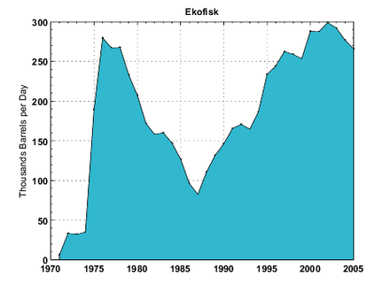
Norpipe is a subsea oil and natural gas pipelines system in the North Sea. It supplies oil from the Norwegian Ekofisk and associated fields in the North Sea to the United Kingdom and natural gas to Germany.
The Forties Oil Field is the second largest oil field in the North Sea, after the Clair oilfield, which is located 110 miles east of Aberdeen. It was discovered in 1970 and first produced oil in 1975 under ownership of British Petroleum, now called BP.
The Sirte Basin is a late Mesozoic and Cenozoic triple junction continental rift along northern Africa that was initiated during the late Jurassic Period. It borders a relatively stable Paleozoic craton and cratonic sag basins along its southern margins. The province extends offshore into the Mediterranean Sea, with the northern boundary drawn at the 2,000 meter (m) bathymetric contour. It borders in the north on the Gulf of Sidra and extends south into northern Chad.
Draugen is an oil field in the Norwegian Sea with a sea depth of 250 metres (800 ft). It had been operated by A/S Norske Shell until sold to AS OKEA in 2018. The field has been developed with a concrete fixed facility and integrated topside. Stabilized oil is stored in tanks in the base of the facility. Two flowlines connect the facility to a floating loading buoy.
Frigg gas field is a natural gas field on Norwegian block 25/1 in the North Sea, on the boundary between the United Kingdom and Norway. The field is named after the goddess Frigg. King Olav V of Norway officially opened production on 8 May 1978. Production was closed on 26 October 2004. The field is situated 230 kilometres (140 mi) northwest of Stavanger. Operator for the field was the French oil company Elf Aquitaine, which merged and changed name to Total S.A.
Oselvar is a subsea oil field, abandoned since April 2018, located 250 km (160 mi) southwest of Stavanger in the southern Norwegian section of the North Sea, close to the British border. Oselvar was discovered in 1991. The field is located at 23 kilometres (14 mi) distance from the Ula field to which it was tied back. The original estimated reserves at Oselvar were 38 million barrels of oil and 4 billion cubic metres of natural gas. The water depth at location is 72 metres (236 ft). In January 2022, DNO ASA reportedly had approval from Norway’s Petroleum Safety Authority (PSA) to remove subsea facilities from the Oselvar field. The Oselvar field installations were to be decommissioned by the end of 2022.
The Oklahoma City Oil Field is one of the world's giant petroleum fields and is located in Oklahoma City, Oklahoma in the United States of America. The field was opened just south of the city limits on December 4, 1928, and first entered Oklahoma City limits on May 27, 1930.
Tambar is an offshore oil field located in the southern Norwegian section of North Sea along with Ula and Gyda fields making up the UGT area, usually attributed to DONG Energy's main areas of exploration and production activity. The Ula field was discovered in 1983 and came online in 2001. Tambar was discovered in 1983 and became operational in July 2001. It contains confirmed 46.9 million m3 of oil.
Randi Martinsen is an American geologist and senior lecturer in the Department of Geology and Geophysics at the University of Wyoming.
{{cite journal}}
: Cite journal requires |journal=
(help){{cite journal}}
: Cite journal requires |journal=
(help)