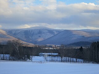
Mount Greylock is the highest point in Massachusetts at 3,489 feet. Located in the northwest region of the state, it is part of the Taconic Mountains, a geologically distinct range from the nearby Berkshires and Green Mountains. Expansive views and a small area of sub-alpine forest characterize its upper reaches. A seasonal automobile road crosses the summit area near three structures from the 1930s; these together constitute a small National Historic District. Various hiking paths including the Appalachian Trail traverse the area, which is part of the larger Mount Greylock State Reservation.

Charles Eliot was an American landscape architect. Known for pioneering principles of regional planning, naturalistic systems approach to landscape architecture, and laying the groundwork for conservancies across the world. Instrumental in the formation of The Trustees of Reservations, the world's first land trust, playing a central role in shaping the Boston Metropolitan Park System, designing a number of public and private landscapes, and wrote prolifically on a variety of topics.

Great Blue Hill is a hill of 635 feet located within the Blue Hills Reservation in Milton, Randolph and Canton, Massachusetts, about 10 miles (16 km) south of downtown Boston. It is the highest point in Norfolk County and the Greater Boston area.

Blue Hills Reservation is a 7,000-acre (2,800 ha) state park in Norfolk County, Massachusetts in the United States. Managed by the Massachusetts Department of Conservation and Recreation, it covers parts of Milton, Quincy, Braintree, Canton, Randolph, and Dedham. Located approximately ten miles south of downtown Boston, the reservation is one of the largest parcels of undeveloped conservation land within the Greater Boston metropolitan area. The park's varied terrain and scenic views make it a popular destination for hikers from the Boston area.

The Blue Hill Meteorological Observatory in Milton, Massachusetts is the foremost structure associated with the history of weather observations in the United States. Located atop Great Blue Hill about 10 miles south of Boston, Massachusetts, it is home to the oldest continuous weather record in North America, and was the location of the earliest kite soundings of the atmosphere in North America in the 1890s, as well as the development of the radiosonde in the 1930s.

The Charles River Reservation is a 17-mile-long (27 km) urban preserve and public recreation area located along the banks of the Charles River in Boston, Cambridge, Watertown, and Newton, Massachusetts. The reservation is managed by the Massachusetts Department of Conservation and Recreation.

The Neponset Valley Parkway is a historic parkway in southern Boston and Milton, Massachusetts, United States. It is a connecting parkway in the Greater Boston area's network, providing a connection between the Blue Hills Reservation, Neponset River Reservation, and the Stony Brook Reservation. The parkway was constructed between 1898 and 1929 with design assistance from Charles Eliot and the Olmsted Brothers. It was listed on the National Register of Historic Places in 2005.

Fresh Pond Parkway is a historic park and parkway on the western end of Cambridge, Massachusetts. It is part of the Metropolitan Park System of Greater Boston. The parkway was built in 1899 and added to the National Register of Historic Places in 2005.
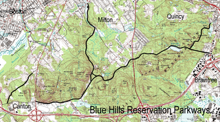
The Blue Hills Reservation Parkways are a network of historic parkways in and around the Blue Hills Reservation, a Massachusetts state park south of Boston, Massachusetts. It consists of six roadways that provide circulation within the park, and that join the park to two connecting parkways, the Blue Hills Parkway and the Furnace Brook Parkway. The roadway network was designed by Charles Eliot in the 1890s, except for Green Street, which was added to the network in the 1940s. The parkways were added to the National Register of Historic Places in 2003.

The Fells Connector Parkways are a group of historic parkways in the cities of Malden and Medford, Massachusetts, suburbs north of the city of Boston. The three parkways, The Fellsway, Fellsway West, and Fellsway East serve to provide access from the lower portion of the Mystic River Reservation to the Middlesex Fells Reservation. The latter two parkways continue northward, providing access to the interior of the Fells and providing a further connection to Lynn Fells Parkway. Significant portions of these parkways south of the Fells, which were among the first connecting parkways designed to be part of the Metropolitan Park System of Greater Boston by Charles Eliot, were listed on the National Register of Historic Places in 2003.

The Charles River Reservation Parkways are parkways that run along either side of the Charles River in eastern Massachusetts. The roads are contained within the Charles River Reservation and the Upper Charles River Reservation, and fall within a number of communities in the greater Boston metropolitan area. The Charles River parks extend from the Charles River Dam, where the Charles empties into Boston Harbor, to Riverdale Park in the West Roxbury neighborhood of Boston. Most of the roadways within the parks are listed on the National Register of Historic Places as a unit, although Storrow Drive and Memorial Drive are listed as part of the Charles River Basin Historic District.

The Chickatawbut Observation Tower is a historic tower on Chickatawbut Road in Quincy, Massachusetts, in the Blue Hill Reservation, a Massachusetts state park.

Furnace Brook Parkway is a historic parkway in Quincy, Massachusetts. Part of the Metropolitan Park System of Greater Boston, it serves as a connector between the Blue Hills Reservation and Quincy Shore Reservation at Quincy Bay. First conceived in the late nineteenth century, the state parkway is owned and maintained by the Massachusetts Department of Conservation and Recreation (DCR) and travels through land formerly owned by the families of John Adams and John Quincy Adams, passing several historic sites. It ends in the Merrymount neighborhood, where Quincy was first settled by Europeans in 1625 by Captain Richard Wollaston. The road was started in 1904, completed in 1916 and added to the National Register of Historic Places (NRHP) in 2004.

Blue Hills Parkway is a historic parkway that runs in a straight line from a crossing of the Neponset River, at the south border of Boston to the north edge of the Blue Hills Reservation in Milton, Massachusetts. It was built in 1893 to a design by the noted landscape architect, Charles Eliot, who is perhaps best known for the esplanades along the Charles River. The parkway is a connecting road between the Blue Hills Reservation and the Neponset River Reservation, and was listed on the National Register of Historic Places in 2003.

The Refreshment Pavilion is a historic refreshment stand at Houghton's Pond in the Milton portion of Blue Hills Reservation, a Massachusetts state park. Built in 1920, it is one of a series of architect-designed structures built in the park by the Metropolitan District Commission. It was listed on the National Register of Historic Places in 1980.

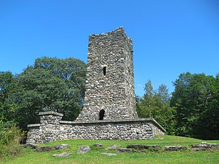
The Great Blue Hill Observation Tower, known locally as Eliot Tower, is a historic stone tower located near the summit of Great Blue Hill in Milton, Massachusetts. The tower was built in the 1930s by the Civilian Conservation Corps (CCC) and is a good example of the rustic architecture CCC projects were known for. The 35-foot-tall (11 m) tower provides views of about 270°, with only the view toward the actual hill summit obscured by vegetation. The tower was added to the National Register of Historic Places in 1980.

Stony Brook Reservation is a woodland park in Boston and Dedham, Massachusetts, a unit of the Metropolitan Park System of Greater Boston, part of the state park system of Massachusetts. It was established in 1894 as one of the five original reservations created by the Metropolitan Park Commission. The park is served by the Stony Brook Reservation Parkways, a road system that was entered into the National Register of Historic Places in 2006.

Garrison Hill Tower is a 76-foot-tall (23 m) observatory atop Garrison Hill in Dover, New Hampshire, United States. The current tower, made of iron and painted green, was built in 1993 and is the third tower to exist on the hill. The park in which it stands is listed on the National Register of Historic Places.

The High Rock Reservation is a city park in the Highlands neighborhood of Lynn, Massachusetts. Designed in 1907 by the Olmsted Brothers, the roughly 7-acre (2.8 ha) park encompasses the summit area of a hill with commanding views of the surrounding area, as well as the Atlantic Ocean which is approximately half a mile away.
Hubbard Park is a 194-acre park (79 ha) located to the north of the Vermont State House in Montpelier, Vermont. The park features approximately 7 miles of hiking and skiing trails, a soccer and ball field, picnic areas, a sledding hill, seven fireplaces, two sheltered pavilions, and a historic 54-foot high observation tower that was built between 1915-1930. The tower was listed on the Vermont State Historic Register on March 15, 1990, and along with its original parcel area, was added to the National Register of Historic Places as part of a Boundary Increase of the Montpelier Historic District on February 20, 2018.


