
Olympic National Park is a national park of the United States located in Washington, on the Olympic Peninsula. The park has four regions: the Pacific coastline, alpine areas, the west-side temperate rainforest, and the forests of the drier east side. Within the park there are three distinct ecosystems, including subalpine forest and wildflower meadow, temperate forest, and the rugged Pacific coast.

The Historic Columbia River Highway is an approximately 75-mile-long (121 km) scenic highway in the U.S. state of Oregon between Troutdale and The Dalles, built through the Columbia River Gorge between 1913 and 1922. As the first planned scenic roadway in the United States, it has been recognized in numerous ways, including being listed on the National Register of Historic Places, being designated as a National Historic Landmark by the U.S. Secretary of the Interior, being designated as a National Historic Civil Engineering Landmark by the American Society of Civil Engineers, and being considered a "destination unto itself" as an All-American Road by the U.S. Secretary of Transportation. The historic roadway was bypassed by the present Columbia River Highway No. 2 from the 1930s to the 1950s, leaving behind the old two-lane road. The road is now mostly owned and maintained by the state through the Oregon Department of Transportation as the Historic Columbia River Highway No. 100 or the Oregon Parks and Recreation Department as the Historic Columbia River Highway State Trail.

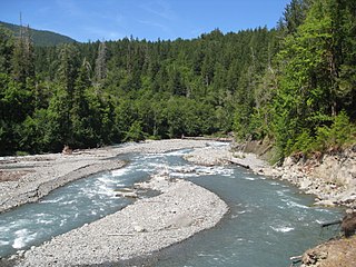
The Elwha River is a 45-mile (72 km) river on the Olympic Peninsula in the U.S. state of Washington. From its source at Elwha snowfinger in the Olympic Mountains, it flows generally north to the Strait of Juan de Fuca. Most of the river's course is within the Olympic National Park.

The Palisades Interstate Park Commission (PIPC) was formed in 1900 by Governors Theodore Roosevelt of New York and Foster Voorhees of New Jersey in response to the quarrying operations along the Palisades Cliffs of New Jersey. The Palisades, a National Natural Landmark that are also called the New Jersey Palisades or the Hudson River Palisades, are a line of steep cliffs along the west side of the lower Hudson River in Northeastern New Jersey and Southeastern New York in the United States. After its formation, the PIPC quickly moved to acquire the lands at the base of the Palisades to stop quarrying operations in both New York and New Jersey. The commission consists of ten commissioners, five appointed by each governor, and was ratified by an Act of Congress in 1937 when its interstate compact was approved. Today, the Commission owns and operates more than 125,000 acres of public parkland in New York and New Jersey including 21 state parks, 8 historic sites, and the Palisades Interstate Parkway. These parks are visited by more than 7 million people annually.

Tse-whit-zen is a 1,700- to 2,700-year-old village of the Lower Elwha Klallam Tribe located along the Port Angeles, Washington waterfront. It is located at the base of Ediz Hook on the Olympic Peninsula. During construction in August 2003 of a graving dock associated with replacement of the Hood Canal Bridge, the village's cemetery and other prehistoric remains were discovered. The construction project was abandoned at this site because of the importance of the find, as the village was intact. It is the largest pre-European contact village site excavated in Washington State.
This is a list of properties and historic districts in Tennessee that are listed on the National Register of Historic Places. There are over 2,000 in total. Of these, 29 are National Historic Landmarks. Each of Tennessee's 95 counties has at least one listing.
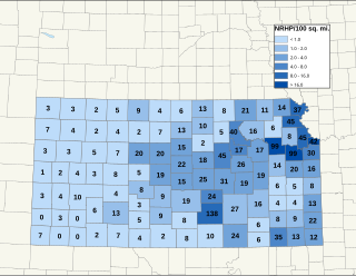
There are over 1,600 buildings, sites, districts, and objects in Kansas listed on the National Register of Historic Places in Kansas. NRHP listings appear in 101 of the state's 105 counties.

The Elwha Dam was a 108-ft high dam located in the United States, in the state of Washington, on the Elwha River approximately 4.9 miles (7.9 km) upstream from the mouth of the river on the Strait of Juan de Fuca.

State Route 128 (SR-128) is a 44.564-mile-long (71.719 km) state highway in the U.S. state of Utah. The entire length of the highway has been designated the Upper Colorado River Scenic Byway, as part of the Utah Scenic Byways program. This road also forms part of the Dinosaur Diamond Prehistoric Highway, a National Scenic Byway. Residents of Moab frequently refer to SR-128 as "the river road", after the Colorado River, which the highway follows.

Glines Canyon Dam, also known as Upper Elwha Dam, was a 210-foot (64 m) tall concrete arch dam that impounded Lake Mills reservoir on the Elwha River in Clallam County, Washington. As of 2015, it is the tallest dam ever to be intentionally breached.

The Humes Ranch cabin was built around the year 1900 by William Humes. William Humes was originally from New York and arrived in the Elwha River area en route to the Klondike. William, his brother, and a cousin liked the area so much they set up homestead sites. In the early 1940s, Herb and Lois Crisler settled into the cabin at Humes Ranch, while they filmed wildlife for what became Walt Disney's film The Olympic Elk. Since acquiring the property from Peninsula Plywood, the National Park Service has restored the cabin, conforming to its original appearance and with much of the original materials. Wood deterioration, however, is occurring, as a result of the moist Olympic Peninsula environment.
The Geyser Valley trail in Olympic National Park is an area along the Elwha River between Rica Canyon and the Grand Canyon of the Elwha, where many homesteaders tried to eke out a living in the late 19th and early 20th centuries. Today, this trail allows hikers to visit several interesting sites, as well as, providing several loops of different lengths.

This is a list of the National Register of Historic Places listings in Blue Earth County, Minnesota. It is intended to be a complete list of the properties and districts on the National Register of Historic Places in Blue Earth County, Minnesota, United States. The locations of National Register properties and districts for which the latitude and longitude coordinates are included below, may be seen in an online map.

Names Hill is a bluff located on the bank of the Green River in the U.S. state of Wyoming, where travelers on the Oregon and California trails carved their names into the rock. It is one of three notable "recording areas" along the emigrant trails in Wyoming along with Register Cliff and Independence Rock. The site was listed on the National Register of Historic Places on April 16, 1969.
The Lower Elwha Klallam Tribe is a federally recognized Native American nation in the Pacific Northwest of the United States. The tribe is part of the larger Klallam culture, part of the Coast Salish people.

The Altair Campground Community Kitchen, also known as Altaire Campground Community Kitchen, was built in Olympic National Park, Washington, United States, to serve the Altair Campground. It is an open rectangular shelter built in 1935 by the Civilian Conservation Corps personnel from the Elwha River Camp in the National Park Service Rustic style.

The Elwha Campground Community Kitchen was built in Olympic National Park to serve the Altair Campground. It is an open octagonal shelter built in 1935 by the Civilian Conservation Corps personnel from the Elwha River Camp in the National Park Service Rustic style. The peeled log structure is capped with a cedar shake roof, enclosing a cooking fireplace and chimney. The Elwha and Altair Campground Community Kitchens are the only such structures remaining in Olympic National Park.

The Canyon Creek Shelter, also known as the Sol Duc Falls Shelter, is a rustic trail shelter in Olympic National Park. It is the last remaining trail shelter built in the park by the Civilian Conservation Corps (CCC) from Camp Elwha. The shelter was built in 1939, shortly after Olympic National Park was established from the U.S. Forest Service-administered Mount Olympus National Monument. Two similar shelters were built at Moose Lake and Hoh Lake, neither of which survived. The one-story log structure is T-shaped, with a projecting front porch crowned by a small cupola. The shelter is open to the front porch.

The Graves Creek Ranger Station is a small historic district in Olympic National Park, Washington, USA. It includes the first administrative buildings to be built by the National Park Service in the newly designated park. The district comprises two buildings built in 1939-41 by the National Park Service in the Graves Creek region of the western park. Labor from the Civilian Conservation Corps and the Public Works Administration was used for both the ranger station residence and the garage-woodshed, as well as for a generator building that no longer stands. The 1939 ranger station residence is a one-story frame structure, clad in cedar shingles. The garage is of similar construction, built in 1941. Both structures are examples of the late National Park Service Rustic style, featuring broad shingle courses and deep eaves.

Dodger Point is a 5,760-foot (1,756-metre) mountain summit located within Olympic National Park in Jefferson County of Washington state.


