
Dorchester is a neighborhood comprising more than 6 square miles (16 km2) in the City of Boston, Massachusetts, United States. Originally, Dorchester was a separate town, founded by Puritans who emigrated in 1630 from Dorchester, Dorset, England, to the Massachusetts Bay Colony. This dissolved municipality, Boston's largest neighborhood by far, is often divided by city planners in order to create two planning areas roughly equivalent in size and population to other Boston neighborhoods.

The Fan is a district of Richmond, Virginia, so named because of the "fan" shape of the array of streets that extend west from Belvidere Street, on the eastern edge of Monroe Park, westward to Arthur Ashe Boulevard. However, the streets rapidly resemble a grid after they go through what is now Virginia Commonwealth University. The Fan is one of the easterly points of the city's West End section, and is bordered to the north by Broad Street and to the south by VA 195, although the Fan District Association considers the southern border to be the properties abutting the south side of Main Street. The western side is sometimes called the Upper Fan and the eastern side the Lower Fan, though confusingly the Uptown district is located near VCU in the Lower Fan. Many cafes and locally owned restaurants are located here, as well as historic Monument Avenue, a boulevard formerly featuring statuary of the Civil War's Confederate president and generals. The only current statue is a more modern one of tennis icon Arthur Ashe. Development of the Fan district was strongly influenced by the City Beautiful movement of the late 19th century.

Spring Hill is a ridge in the central part of the city of Somerville, Massachusetts, United States, and the residential neighborhood that sits atop it. It runs northwest to southeast, roughly bounded by Highland Avenue, Somerville Avenue, Elm Street, and Willow Avenue. Summer Street runs along the hill's crest.

The Elmwood Historic District encompasses two large residential sections of the Elmwood neighborhood of Providence, Rhode Island. The Elmwood area was mainly farmland until the mid-19th century, when its development as a residential area began, and these two sections represents well-preserved neighborhoods developed between about 1850 and 1920. The district was listed on the National Register of Historic Places in 1980.

The Sumner Hill Historic District encompasses a predominantly residential area of high-quality late 19th-century residences in the Jamaica Plain neighborhood of Boston, Massachusetts. It is roughly bounded by Seaverns Avenue, Everett Street, Carolina Avenue, and Newbern Street just east of the neighborhoods commercial Centre Street area. The district features Second Empire, Italianate, and Queen Anne style architecture, and was listed on the National Register of Historic Places in 1987.

The Maple Avenue Historic District is a residential historic district on Maple Avenue between Marie Avenue and Broadway in Cambridge, Massachusetts, United States. It encompasses a street with a cohesive collection of well-preserved, predominantly Italianate and Second Empire, houses, in which the original spacing and setting has been preserved. It includes houses on both sides of Maple Avenue, numbered from 8 to 33, among which stand several Queen Anne and Colonial Revival houses. The district was added to the National Register of Historic Places in 1983.
The Prospect Hill Historic District is an irregularly-shaped 185-acre (75 ha) historic district in New Haven, Connecticut. The district encompasses most of the residential portion of the Prospect Hill neighborhood.

The West Canfield Historic District is a neighborhood historic district located primarily on Canfield Avenue between Second and Third Streets in Detroit, Michigan. A boundary increase enlarged the district to include buildings on Third Avenue between Canfield and Calumet. The district was designated a Michigan State Historic Site in 1970 and listed on the National Register of Historic Places in 1971; a boundary increase was added in 1997. The revitalized 1870s era neighborhood is one of the residential areas surrounding the city's Cultural Center Historic District in Midtown. Nearby, East Canfield Avenue leads to the Detroit Medical Center complex, the Romanesque Revival styled St. Josaphat's Catholic Church, and the Gothic revival styled Sweetest Heart of Mary Catholic Church.

Buttonwood Park Historic District is a historic district on Kempton Street, Rockdale Avenue, Hawthorne Street and Brownell Avenue in New Bedford, Massachusetts. Its focal point is Buttonwood Park, a 97-acre (39 ha) municipal park planned by Charles Eliot in the 1890s, and part of its surrounding neighborhood. The neighborhood was developed in the first decades of the 20th century as a complement to the park, and contains a fine selection of Colonial Revival and Craftsman style houses. The district was added to the National Register of Historic Places in 2000.

The Yale Avenue Historic District is a residential historic district near the center of Wakefield, Massachusetts. It encompasses eight residential properties, all but one of which were developed in the 1860s and 1870s, after the arrival of the railroad in town. These properties were built primarily for Boston businessmen, and mark the start of Wakefield's transition to a suburb.

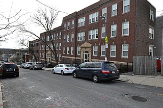
The Columbia Road–Bellevue Street Historic District encompasses a collection of brick residential apartment houses on Columbia Road and Bellevue Street in the Dorchester neighborhood of Boston, Massachusetts. Arrayed mainly on Columbia Road between Wheelock Avenue and Bodwell Street, south of the Uphams Corner commercial area, area collection of primarily late 19th and early 20th-century multiunit residential buildings, built when the area was developed as a streetcar suburb. Most of these are Colonial Revival masonry or frame buildings three and four stories in height, although some exhibit Queen Anne features. There are a few older Greek Revival buildings in the district, and a number of apartment blocks built in the 1920s during a second phase of development.

The Center Avenue Neighborhood Residential District is a residential historic district located in Bay City, Michigan, running primarily along Center, Fifth, and Sixth Avenues between Monroe and Green Avenues, with additional portions of the district along Fourth between Madison and Johnson, down to Tenth Avenue between Madison and Lincoln, along Green to Ridge, and around Carroll Park. The original section, along Center and portions of Fifth and Sixth, was listed on the National Register of Historic Places in 1982. A boundary increase including the other sections of the neighborhood was listed in 2012.

The Intervale Street-Columbia Road Historic District is a historic district encompassing a small residential area in the Dorchester neighborhood of Boston, Massachusetts. Centered on a stretch of Intervale Street, the area was developed in the early 20th century during a major Jewish migration, and includes a fine sample of Colonial Revival architecture. The district was listed on the National Register of Historic Places in 2019.
The Cartoof & Sherman Apartments are a group of three historic apartment houses at 31-35 Wales Street in the Dorchester neighborhood of Boston, Massachusetts. Built in 1925, they are well-preserved examples of Colonial Revival architecture, built during a period of growth fueled by the city's expanding streetcar network. The apartments were listed on the National Register of Historic Places in 2020.

The Intervale Street-Blue Hill Avenue Historic District is a historic district encompassing a densely built residential area in the Dorchester neighborhood of Boston, Massachusetts. Centered on a stretch of Intervale Street near Blue Hill Avenue, the area was developed in the late 19th and early 20th centuries during a major Jewish migration, and includes a fine sample of Colonial Revival architecture. The district was listed on the National Register of Historic Places in 2020.

The Elm Hill Park Historic District is a historic district encompassing a small residential area in the Roxbury neighborhood of Boston, Massachusetts. It encompasses a residential development created in the early 20th century, including fine examples of Colonial Revival and Queen Anne wood-frame construction, as well as a series of brick Romanesque apartment houses. The district was listed on the National Register of Historic Places in 2021.

The Lawrence Avenue Historic District is a historic district encompassing a small residential area in the Dorchester neighborhood of Boston, Massachusetts. Centered on Lawrence Avenue, the area was developed in the late 19th and early 20th century during a major Jewish migration, and includes a fine sample of Colonial Revival and Queen Anne architecture. The district was listed on the National Register of Historic Places in 2021.

The Humboldt Avenue Historic District is a historic district encompassing a cluster of multifamily brick buildings in the Dorchester neighborhood of Boston, Massachusetts. Centered on the junction of Humboldt Avenue and Hutchings Street, the area was developed in 1915-16 during a major Jewish migration, and includes a fine sample of Colonial Revival architecture. The district was listed on the National Register of Historic Places in 2021.

The Charlotte Street-Esmond Street Historic District is a historic district encompassing a residential subdivision in the Dorchester neighborhood of Boston, Massachusetts. Centered on Charlotte and Esmond Streets, the area was developed in the early 20th century following the arrival of electrified street cars on nearby Blue Hill Avenue. The district was listed on the National Register of Historic Places in 2022.

The Dudley Terrace–Dudley Street Historic District is a historic district encompassing a cluster of four multifamily brick buildings in the Dorchester neighborhood of Boston, Massachusetts. Centered on the junction of Dudley Street and Virginia Avenue, the area was developed in the mid-1890s, and includes good examples of Queen Anne and Renaissance Revival architecture. The district was listed on the National Register of Historic Places in 2022.


