Eureka Roadhouse, Alaska

Last updated

Eureka Roadhouse, Alaska
The Fireweed 400.jpg
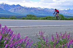
A cyclist in the defunct Fireweed 400 race is seen passing by Eureka Lodge on the Glenn Highway in July 2010.
Matanuska-Susitna Borough Alaska incorporated and unincorporated areas Eureka Roadhouse highlighted.svg
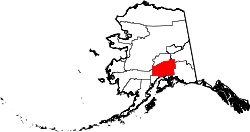
Location in Matanuska-Susitna Borough and the state of Alaska
USA Alaska location map.svg
Red pog.svg
Eureka Roadhouse, Alaska
Location within the state of Alaska
Coordinates: 61°57′53″N147°9′6″W / 61.96472°N 147.15167°W / 61.96472; -147.15167
Country United States
State Alaska
Borough Matanuska-Susitna
Government
  Borough mayor Edna DeVries
   State senator Mike Shower (R)
   State rep. George Rauscher (R) [1]
Area
[2]
  Total187.34 sq mi (485.20 km2)
  Land185.78 sq mi (481.17 km2)
  Water1.56 sq mi (4.03 km2)
Elevation
3,287 ft (1,002 m)
Population
 (2020) [3]
  Total24
  Density0.13/sq mi (0.05/km2)
Time zone UTC-9 (Alaska (AKST))
  Summer (DST) UTC-8 (AKDT)
ZIP Codes
99588, 99674
Area code 907
FIPS code 02-23720

Eureka Roadhouse is a census-designated place (CDP) in the Matanuska-Susitna Borough in the U.S. state of Alaska. It is part of the Anchorage Metropolitan Area. The population was 24 at the 2020 census. [3]

Contents

Geography

Eureka Roadhouse is located between the CDPs of Glacier View and Nelchina on the Glenn Highway (Alaska Route 1), between the Chugach Mountains to the north and the Talkeetna Mountains to the southeast. The northern part of the CDP is occupied by the Nelchina Public Use Area.

It is 122 miles (196 km) northeast of Anchorage by road.

According to the United States Census Bureau, the CDP has a total area of 187.3 square miles (485 km2), of which 185.8 square miles (481 km2) are land and 1.6 square miles (4.1 km2), or 0.83%, are water. [2]

Demographics

Historical population
CensusPop.Note
2010 29
2020 24−17.2%
U.S. Decennial Census [4]

As of the census of 2010, there were 29 people, 16 households, and 6 families residing in the CDP. The population density was 0.15 inhabitants per square mile (0.058/km2). The racial makeup of the CDP was 22 (75.86%) White, 0 (0.0%) Black or African American, 2 (6.9%) Native American, 1 (3.4%) Asian, 0 (0.0%) from other races, and 4 (13.8%) from two or more races. 2 (6.9%) of the population were Hispanic or Latino of any race.

There were 101 housing units, of which 16 were occupied. Of the 16 households, 3 (18.8%) had children under the age of 18 living with them, 5 (31.3%) were married couples living together, 1 (6.3%) had a female householder with no husband present, and 10 (62.5%) were non-families. 9 (56.3%) of all households were made up of individuals, and 6 (35.5%) had someone living alone who was 65 years of age or older. The average household size was 1.81 and the average family size was 2.83.

In the CDP, the population was spread out, with 5 (17.1%) under the age of 18, 2 (6.9%) from 18 to 24, 3 (10.2%) from 25 to 44, 11 (37.8%) from 45 to 64, and 8 (27.5%) who were 65 years of age or older. The median age was 53.3 years. For every 100 females, there were 222.2 males (20 males, 9 females). For every 100 females age 18 and over, there were 200 males (16 adult males, 8 adult females). [5] [6]

Income data was not present for Eureka Roadhouse.

Related Research Articles

<span class="mw-page-title-main">Valdez–Cordova Census Area, Alaska</span> Census area in Alaska, United States

Valdez–Cordova Census Area was a census area located in the state of Alaska, United States. As of the 2010 census, the population was 9,636. It was part of the Unorganized Borough and therefore had no borough seat. On January 2, 2019, it was abolished and replaced by the Chugach Census Area and the Copper River Census Area.

<span class="mw-page-title-main">Cooper Landing, Alaska</span> Census-designated place in Alaska, United States

Cooper Landing is a census-designated place (CDP) in Kenai Peninsula Borough, Alaska, United States, about 100 miles (160 km) south of Anchorage, at the outlet of Kenai Lake into the Kenai River. The town was first settled in the 19th century by gold and mineral prospectors, and has become a popular summer tourist destination thanks to its scenic location and proximity to the salmon fishery of the Kenai River and Russian River. As of the 2010 census, the population in Cooper Landing was 289, down from 369 in 2000.

<span class="mw-page-title-main">Kalifornsky, Alaska</span> Census-designated place in Alaska, United States

Kalifornsky is a census-designated place (CDP) in Kenai Peninsula Borough, Alaska, United States. The population was 8,487 at the 2020 census, up from 7,850 in 2010. It is the most populated locality in the borough.

<span class="mw-page-title-main">Moose Pass, Alaska</span> Census-designated place in Alaska, United States

Moose Pass is a census-designated place (CDP) in Kenai Peninsula Borough, Alaska, United States. The population was 219 at the 2010 census, up from 206 in 2000.

<span class="mw-page-title-main">Buffalo Soapstone, Alaska</span> CDP in Alaska, United States

Buffalo Soapstone is a census-designated place (CDP) in Matanuska-Susitna Borough, Alaska, United States. It is part of the Anchorage, Alaska Metropolitan Statistical Area. The population was 1,021 at the 2020 census, up from 855 in 2010.

<span class="mw-page-title-main">Fishhook, Alaska</span> CDP in Alaska, United States

Fishhook is a census-designated place (CDP) in Matanuska-Susitna Borough, Alaska, United States. It is part of the Anchorage, Alaska Metropolitan Statistical Area. At the 2020 census the population was 5,048, up from 4,679 in 2010.

<span class="mw-page-title-main">Gateway, Alaska</span> CDP in Alaska, United States

Gateway is a census-designated place (CDP) in Matanuska-Susitna Borough, Alaska, United States. It is part of the Anchorage, Alaska Metropolitan Statistical Area. The population was 5,748 at the 2020 census, up from 5,552 in 2010. Gateway is the fifth-most populated CDP in the borough.

<span class="mw-page-title-main">Glacier View, Alaska</span> Census-designated place in Alaska, United States

Glacier View is a census-designated place (CDP) in Matanuska-Susitna Borough, Alaska, United States. It is part of the Anchorage Metropolitan Area. At the 2020 census the population was 375, up from 234 in 2010. The terminus of Matanuska Glacier is located approximately three miles southwest of Glacier View.

<span class="mw-page-title-main">Knik River, Alaska</span> CDP in Alaska, United States

Knik River is a census-designated place (CDP) in Matanuska-Susitna Borough in the U.S. state of Alaska. Located 15 miles southeast from Palmer along the Knik River, it is part of the Anchorage, Alaska Metropolitan Statistical Area. The population was 792 at the 2020 census, up from 744 in 2010.

<span class="mw-page-title-main">Lake Louise, Alaska</span> Census-designated place in Alaska, United States

Lake Louise is a census-designated place (CDP) in Matanuska-Susitna Borough, Alaska, United States. Although it is an isolated settlement and is close to Glennallen, it is considered part of the Anchorage Metropolitan Area, like all other locations in the Mat-Su Borough. At the 2020 census the population was 15, down from 46 in 2010 and 88 in 2000.

<span class="mw-page-title-main">Lakes, Alaska</span> CDP in Alaska, United States

Lakes was a census-designated place (CDP) in Matanuska-Susitna Borough, Alaska, United States. It was split in two CDPs for 2020 Census purposes: North Lakes and South Lakes. The area is part of the Anchorage, Alaska Metropolitan Statistical Area. At the 2010 census the population was 8,364, up from 6,706 in 2000.

<span class="mw-page-title-main">Petersville, Alaska</span> Census-designated place in Alaska, United States

Petersville is a census-designated place (CDP) in Matanuska-Susitna Borough, Alaska, United States. It is part of the Anchorage Metropolitan Area. The population was 27 at the 2020 census.

<span class="mw-page-title-main">Point MacKenzie, Alaska</span> CDP in Alaska, United States

Point MacKenzie is a census-designated place (CDP) in Matanuska-Susitna Borough, Alaska, United States. It is part of the Anchorage, Alaska Metropolitan Statistical Area. At the 2020 census the population was 1,852, up from 529 in 2010.

<span class="mw-page-title-main">Sutton-Alpine, Alaska</span> Census-designated place in Alaska, United States

Sutton is a census-designated place (CDP) in the Matanuska-Susitna Borough in the U.S. state of Alaska. At the 2020 census the population was 1,038, down from 1,447 in 2010. The CDP includes the former coal mining community and road construction camp of Sutton, as well as the former mining camps of Eska and Jonesville.

<span class="mw-page-title-main">Big Delta, Alaska</span> CDP in the United States

Big Delta is a census-designated place (CDP) in Southeast Fairbanks Census Area, Alaska, United States. The population was 591 at the 2010 census, down from 749 in 2000. Big Delta is at the confluence of the Delta River and the Tanana River and gets its name from the huge river delta formed by the confluence.

<span class="mw-page-title-main">Chistochina, Alaska</span> CDP in Alaska, United States

Chistochina is a census-designated place (CDP) in Copper River Census Area, Alaska, United States. At the 2020 census the population was 60, down from 93 in 2010.

<span class="mw-page-title-main">Copper Center, Alaska</span> CDP in Alaska, United States

Copper Center is a census-designated place (CDP) on the Copper River in Copper River Census Area, Alaska, United States. It is two hundred kilometers northeast of Anchorage. At the 2020 census the population was 338, up from 328 in 2000.

Nelchina is a census-designated place (CDP) in Copper River Census Area, Alaska, United States. The population was 45 at the 2020 census, down from 59 in 2010.

<span class="mw-page-title-main">Tonsina, Alaska</span> CDP in Alaska, United States

Tonsina is a census-designated place (CDP) in Copper River Census Area, Alaska, United States. At the 2020 census the population was 55, down from 78 in 2010.

<span class="mw-page-title-main">Manley Hot Springs, Alaska</span> CDP in Alaska, United States

Manley Hot Springs is a census-designated place (CDP) in Yukon-Koyukuk Census Area, Alaska, United States. At the 2020 census the population was 169, up from 89 in 2010.

References

  1. "Archived copy" (PDF). Archived from the original (PDF) on November 18, 2016. Retrieved October 1, 2016.{{cite web}}: CS1 maint: archived copy as title (link)
  2. 1 2 "2021 U.S. Gazetteer Files: Alaska". United States Census Bureau. Retrieved May 3, 2022.
  3. 1 2 "Eureka Roadhouse CDP, Alaska: 2020 DEC Redistricting Data (PL 94-171)". U.S. Census Bureau. Retrieved May 3, 2022.
  4. "Census of Population and Housing". Census.gov. Retrieved June 4, 2016.
  5. "U.S. Census website". United States Census Bureau . Retrieved October 1, 2016.
  6. "Eureka Roadhouse, AK Population - Census 2010 and 2000 Interactive Map, Demographics, Statistics, Quick Facts - CensusViewer". censusviewer.com. Archived from the original on October 3, 2016. Retrieved October 4, 2021.