Falcon Mesa, Texas

Last updated
Falcon Mesa, Texas
CDP
TXMap-doton-FalconMesa.PNG
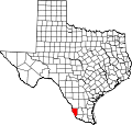
Location of Falcon Mesa, Texas
Zapata County Falcon Mesa.svg
Coordinates: 26°52′22″N99°17′20″W / 26.87278°N 99.28889°W / 26.87278; -99.28889 Coordinates: 26°52′22″N99°17′20″W / 26.87278°N 99.28889°W / 26.87278; -99.28889
Country United States
State Texas
County Zapata
Area
  Total3.46 sq mi (9.0 km2)
  Land1.52 sq mi (3.9 km2)
  Water1.94 sq mi (5.0 km2)
Elevation
367 ft (112 m)
Population
 (2010)
  Total405
  Density120/sq mi (45/km2)
Time zone UTC-6 (Central (CST))
  Summer (DST) UTC-5 (CDT)
Zip Code
78076
FIPS code 48-25352 [1]
GNIS feature ID1335665 [2]

Falcon Mesa is a census-designated place (CDP) in Zapata County, Texas, United States. The population was 405 at the 2010 census.

Contents

Geography

Falcon Mesa is located at 26°52′22″N99°17′20″W / 26.87278°N 99.28889°W / 26.87278; -99.28889 (26.872812, -99.288953). [3]

According to the United States Census Bureau, the CDP has a total area of 3.46 square miles (9.0 km2), of which, 1.52 square miles (3.9 km2) of it is land and 1.94 square miles (5.0 km2) is water. [4]

Demographics

Historical population
CensusPop.
2000 506
2010 405−20.0%

As of the census [1] of 2000, there were 506 people, 242 households, and 168 families residing in the CDP. The population density was 331.1 people per square mile (127.7/km2). There were 546 housing units at an average density of 357.3/sq mi (137.8/km2). The racial makeup of the CDP was 91.50% White, 0.40% African American, 0.40% Native American, 0.20% Asian, 5.93% from other races, and 1.58% from two or more races. Hispanic or Latino of any race were 30.63% of the population.

There were 242 households, out of which 13.6% had children under the age of 18 living with them, 65.3% were married couples living together, 3.7% had a female householder with no husband present, and 30.2% were non-families. 28.1% of all households were made up of individuals, and 22.7% had someone living alone who was 65 years of age or older. The average household size was 2.09 and the average family size was 2.51.

In the CDP, the population was spread out, with 14.0% under the age of 18, 4.3% from 18 to 24, 12.3% from 25 to 44, 24.9% from 45 to 64, and 44.5% who were 65 years of age or older. The median age was 62 years. For every 100 females, there were 99.2 males. For every 100 females age 18 and over, there were 95.1 males.

The median income for a household in the CDP was $24,792, and the median income for a family was $26,645. Males had a median income of $16,250 versus $48,021 for females. The per capita income for the CDP was $12,150. About 19.8% of families and 21.0% of the population were below the poverty line, including 25.5% of those under age 18 and 15.0% of those age 65 or over.

Education

All of Zapata County is a part of the Zapata County Independent School District.

Related Research Articles

Round Rock, Arizona Census-designated place in Arizona, United States

Round Rock is a census-designated place (CDP) in Apache County, Arizona, United States. The population was 789 at the 2010 census. It is named after a nearby mesa.

First Mesa, Arizona CDP in Arizona, United States

First Mesa is a census-designated place (CDP) in Navajo County, Arizona, United States, on the Hopi Reservation. As of the 2010 census, the CDP population was 1,555, spread among three Hopi villages atop the 5,700-foot mesa: Hano, Sitsomovi, and Waalpi.

Second Mesa, Arizona CDP in Arizona, United States

Second Mesa is a census-designated place (CDP) in Navajo County, Arizona, on the Hopi Reservation, atop the 5,700-foot mesa. As of the 2010 census, the CDP population was 962, spread among three Hopi Indian villages, Musungnuvi, Supawlavi, and Songoopavi. The Hopi Cultural Center is on Second Mesa.

Cordes Lakes, Arizona CDP in Arizona, United States

Cordes Lakes is a census-designated place (CDP) in Yavapai County, Arizona, United States. The population was 2,058 at the 2000 census. The Agua Fria National Monument lies to the east and south of the community and Arcosanti is to the north.

Mesa, California Census-designated place in California, United States

Mesa is a census-designated place (CDP) in Inyo County, California, United States. The population was 251 at the 2010 census, up from 214 at the 2000 census.

Mountain Mesa, California census-designated place in California, United States

Mountain Mesa is a census-designated place (CDP) in Kern County, California, United States. Mountain Mesa is located 2 miles (3.2 km) west of South Lake at an elevation of 2,641 feet (805 m). The population was 777 at the 2010 census, up from 716 at the 2000 census.

Orosi, California census-designated place in California, United States

Orosi is a census-designated place (CDP) in Tulare County, California, United States. The population was 8,770 at the 2010 census, up from 7,318 at the 2000 census.

Redlands, Colorado CDP in State of Colorado, United States

Redlands is a census-designated place (CDP) in Mesa County, Colorado, United States. The population was 8,685 at the 2010 census. It is an unincorporated community comprising the area between the cities of Grand Junction and Fruita.

San Felipe Pueblo, New Mexico CDP in New Mexico, United States

San Felipe Pueblo is a census-designated place (CDP) in Sandoval County, New Mexico, United States, and is located 10 miles (16 km) north of Bernalillo. As of the 2000 census, the CDP population was 2,080. It is part of the Albuquerque Metropolitan Statistical Area. The Pueblo, founded in 1706, comprises Native Americans who speak an eastern dialect of the Keresan languages.

Glide, Oregon Census-designated place in Oregon, United States

Glide is a census-designated place (CDP) in Douglas County, Oregon, United States. The population was 1,795 at the 2010 census.

Zapata Ranch, Texas CDP in Texas, United States

Zapata Ranch is a census-designated place (CDP) in Willacy County, Texas, United States. The population was 108 at the 2010 census.

Falcon Lake Estates, Texas CDP in Texas, United States

Falcon Lake Estates is a census-designated place (CDP) in Zapata County, Texas, United States. The population was 1,036 at the 2010 census.

Lopeño, Texas CDP in Texas, United States

Lopeño is a census-designated place (CDP) in Zapata County, Texas, United States. The population was 174 at the 2010 census.

Medina, Zapata County, Texas CDP in Texas, United States

Medina is a census-designated place (CDP) in Zapata County, Texas, United States. The population was 3,935 at the 2010 census.

Morales-Sanchez, Texas CDP in Texas, United States

Morales-Sanchez is a census-designated place (CDP) in Zapata County, Texas, United States. The population was 84 at the 2010 census.

New Falcon, Texas CDP in Texas, United States

New Falcon is a census-designated place (CDP) in Zapata County, Texas, United States. The population was 191 at the 2010 census.

San Ygnacio, Texas CDP in Texas, United States

San Ygnacio is a census-designated place (CDP) in Zapata County, Texas, in the United States. As of the 2010 census, the CDP population was 667. It is named for the prominent Spanish saint, Ignatius of Loyola. The portion of the community between the Rio Grande and U.S. Highway 83 is listed on the National Register of Historic Places as San Ygnacio Historic District.

Siesta Shores, Texas CDP in Texas, United States

Siesta Shores is a census-designated place (CDP) in Zapata County, Texas, United States. The population was 1,382 at the 2010 census.

Zapata, Texas CDP in Texas, United States

Zapata is a census-designated place (CDP) in and the county seat of Zapata County, Texas, United States. The population was 5,089 at the 2010 census. As an unincorporated community, Zapata has no municipal government but like all 254 Texas counties has four elected county commissioners chosen by single-member districts and a countywide elected administrative judge.

Slater, Wyoming CDP in Wyoming, United States

Slater is a census-designated place (CDP) in Platte County, Wyoming, United States. The population was 80 at the 2010 census.

References

  1. 1 2 "U.S. Census website". United States Census Bureau . Retrieved 2008-01-31.
  2. "US Board on Geographic Names". United States Geological Survey. 2007-10-25. Retrieved 2008-01-31.
  3. "US Gazetteer files: 2010, 2000, and 1990". United States Census Bureau. 2011-02-12. Retrieved 2011-04-23.
  4. "US Gazetteer Files 2016-Places-Texas". US Census. Retrieved 9 January 2017.