Medina, Zapata County, Texas

Last updated
Medina, Texas
CDP
USA Texas location map.svg
Red pog.svg
Medina, Texas
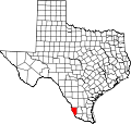
Location within the state of Texas
Coordinates: 26°55′16″N99°15′34″W / 26.92111°N 99.25944°W / 26.92111; -99.25944
Country United States
State Texas
County Zapata
Area
  Total1.8 sq mi (4.6 km2)
  Land1.8 sq mi (4.6 km2)
  Water0.0 sq mi (0.0 km2)
Elevation
397 ft (121 m)
Population
 (2010)
  Total3,935
  Density2,200/sq mi (860/km2)
Time zone UTC-6 (Central (CST))
  Summer (DST) UTC-5 (CDT)
Zip Code
78076
FIPS code 48-47406 [1]
GNIS feature ID1852735 [2]

Medina is a census-designated place (CDP) in Zapata County, Texas, United States. The population was 3,935 at the 2010 census. [3]

Contents

Geography

Medina is located at 26°55′16″N99°15′34″W / 26.92111°N 99.25944°W / 26.92111; -99.25944 (26.93545, -99.264707). [4]

According to the United States Census Bureau, the CDP has a total area of 1.8 square miles (4.6 km2), of which 1.8 square miles (4.6 km2) is land and 0.56% is water.

Demographics

2020 census

Medina racial composition [5]
(NH = Non-Hispanic) [lower-alpha 1]
RaceNumberPercentage
White (NH)822.07%
Black or African American (NH)30.08%
Native American or Alaska Native (NH)20.05%
Asian (NH)30.08%
Mixed/Multi-Racial (NH)30.08%
Hispanic or Latino 3,86097.65%
Total3,953

As of the 2020 United States census, there were 3,953 people, 1,299 households, and 1,099 families residing in the CDP.

2000 census

At the 2000 census, [1] there were 2,960 people, 797 households and 706 families residing in the CDP. The population density was 1,675.2 per square mile (645.7/km2). There were 999 housing units at an average density of 565.4 per square mile (218.3/km2). The racial makeup of the CDP was 81.96% White, 0.30% African American, 0.41% Native American, 0.20% Asian, 0.03% Pacific Islander, 14.80% from other races, and 2.30% from two or more races. Hispanic or Latino of any race were 93.5% of the population.

There were 797 households, of which 63.4% had children under the age of 18 living with them, 68.8% were married couples living together, 15.1% had a female householder with no husband present, and 11.3% were non-families. 10.5% of all households were made up of individuals, and 4.9% had someone living alone who was 65 years of age or older. The average household size was 3.71 and the average family size was 3.99.

42.7% of the population were under the age of 18, 11.4% from 18 to 24, 27.4% from 25 to 44, 12.0% from 45 to 64, and 6.5% who were 65 years of age or older. The median age was 22 years. For every 100 females, there were 98.4 males. For every 100 females age 18 and over, there were 94.4 males.

The median household income was $24,453 and the median family income was $25,576. Males had a median income of $19,593 versus $13,583 for females. The per capita income for the CDP was $6,342. About 38.2% of families and 48.1% of the population were below the poverty line, including 55.9% of those under age 18 and 26.3% of those age 65 or over.

Related Research Articles

<span class="mw-page-title-main">West Rancho Dominguez, California</span> Unincorporated community in California, United States

West Rancho Dominguez, formerly known as West Compton, is an unincorporated census-designated place (CDP) located in southern Los Angeles County, California. Per the 2020 census, the population was 24,347. The community lies to the west of the city of Compton. The ZIP Codes encompassing the CDP area are 90220 & 90248.

<span class="mw-page-title-main">Winter Gardens, California</span> Census-designated place in California, United States

Winter Gardens is a census-designated place (CDP) in San Diego County, California. The population was 20,631 at the 2010 census, up from 19,771 at the 2000 census.

<span class="mw-page-title-main">Country Club, California</span> Census-designated place in California, United States

Country Club is a census-designated place (CDP) in San Joaquin County, California, United States. The population was 9,379 at the 2010 census, down from 9,462 at the 2000 census. It comprises an unincorporated "island" within the City of Stockton.

<span class="mw-page-title-main">Green Valley, Solano County, California</span> Census-designated place in California, United States

Green Valley is a census-designated place (CDP) located in Solano County, California, United States. It sits in the northeast corner of the San Francisco Bay Area and is located approximately 45 miles (72 km) from Sacramento, approximately 38 miles (61 km) from San Francisco, approximately 32 miles (51 km) from Oakland, less than 15 miles (24 km) from Napa Valley, and less than 15 miles (24 km) from both the Carquinez Bridge and the Benicia Bridge.

<span class="mw-page-title-main">Thompsonville, Connecticut</span> Census-designated place in Connecticut, United States

Thompsonville is a census-designated place (CDP) in the town of Enfield in Hartford County, Connecticut, United States. The population of the CDP was 8,577 at the 2010 census.

<span class="mw-page-title-main">Gulf Gate Estates, Florida</span> Census-designated place in Florida, United States

Gulf Gate Estates is a census-designated place (CDP) in Sarasota County, Florida, United States. The population was 10,911 at the 2010 census. It is part of the North Port–Sarasota–Bradenton Metropolitan Statistical Area.

<span class="mw-page-title-main">Preston Heights, Illinois</span> Census-designated place in Illinois, United States

Preston Heights is a census-designated place (CDP) in Will County, Illinois, United States. As of the 2020 census, the CDP population was 2,898.

<span class="mw-page-title-main">Bennsville, Maryland</span> Census-designated place in Maryland, United States

Bennsville is a census-designated place (CDP) in Charles County, Maryland, United States. Per the 2020 census, the population was 15,288. The area is not an official postal designation, but is part of the Waldorf or Pomfret postal area. The Bennsville area is growing with new residential development, encouraged by the extension in the 1990s of Maryland Route 228 which provides quick access to Maryland Route 210. Bennsville has experienced the 2006 opening of North Point High School and the straightening of Middletown Road in 2008.

<span class="mw-page-title-main">Green Valley, Maryland</span> Census-designated place in Maryland

Green Valley is an unincorporated area and census-designated place (CDP) in southern Frederick County, Maryland, United States. The population was 12,643 at the 2020 census. The area was listed as a census-designated place in 2000 but not listed as part of any CDP at the 2010 census. It was re-designated a census-designated place for the 2020 census.

<span class="mw-page-title-main">Fairland, Maryland</span> Census-designated place in Maryland, United States

Fairland is a census-designated place and an unincorporated area in Montgomery County, Maryland, United States. It had a population of 25,396 per the 2020 census.

<span class="mw-page-title-main">West Laurel, Maryland</span> Census-designated place in Maryland

West Laurel is an unincorporated area and census-designated place (CDP) in Prince George's County, Maryland, United States. Per the 2020 census, the population was 4,428.

<span class="mw-page-title-main">Nellieburg, Mississippi</span> Census-designated place in Mississippi, United States

Nellieburg is an unincorporated community and census-designated place (CDP) in Lauderdale County, Mississippi, United States. The population was 1,316 at the 2020 census. It is a suburb of Meridian.

<span class="mw-page-title-main">Flanders, New York</span> Hamlet and census-designated place in New York, United States

Flanders is a hamlet and a census-designated place (CDP) in Suffolk County, New York, United States. The population was 4,472 at the 2010 census. It is the location of the Big Duck.

<span class="mw-page-title-main">Gordon Heights, New York</span> Hamlet and census-designated place in New York, United States

Gordon Heights is a hamlet and census-designated place (CDP) in the Town of Brookhaven, Suffolk County, Long Island, New York, United States. The population was 3,981 at the 2020 census.

<span class="mw-page-title-main">Amsterdam, Ohio</span> Village in Ohio, United States

Amsterdam is a village in northwestern Jefferson County, Ohio, United States. The population was 436 at the 2020 census. The community was founded by Dutch immigrant David Johnson and named after the city of Amsterdam, Netherlands. It is part of the Weirton–Steubenville metropolitan area.

<span class="mw-page-title-main">Old Orchard, Pennsylvania</span> Place in Pennsylvania, United States

Old Orchard is a census-designated place (CDP) in Palmer Township in Northampton County, Pennsylvania. As of the 2010 census, Old Orchard had a total population of 2,434. Old Orchard is part of the Lehigh Valley, which had a population of 861,899 and was the 68th-most populous metropolitan area in the U.S. as of the 2020 census.

<span class="mw-page-title-main">Rendon, Texas</span> CDP in Texas, United States

Rendon is a census-designated place (CDP) in Tarrant County, Texas, United States. The population was 12,552 at the 2010 census.

<span class="mw-page-title-main">Chamberlayne, Virginia</span> Census-designated place in Virginia

Chamberlayne is a census-designated place (CDP) in Henrico County, Virginia, United States. The population was 5,581 at the 2020 census.

<span class="mw-page-title-main">Montrose, Virginia</span> Census-designated place in Virginia

Montrose is a census-designated place (CDP) in Henrico County, Virginia, United States. The population was 7,909 at the 2020 census.

<span class="mw-page-title-main">Carson, Washington</span> CDP in Washington, United States

Carson is a small census-designated place in the Columbia River Gorge National Scenic Area, north of the Columbia River in Skamania County, in the southwestern part of Washington, United States.

References

  1. 1 2 "U.S. Census website". United States Census Bureau . Retrieved 2008-01-31.
  2. "US Board on Geographic Names". United States Geological Survey. 2007-10-25. Retrieved 2008-01-31.
  3. "U.S. Census website". United States Census Bureau . Retrieved 2011-05-14.
  4. "US Gazetteer files: 2010, 2000, and 1990". United States Census Bureau. 2011-02-12. Retrieved 2011-04-23.
  5. "Explore Census Data". data.census.gov. Retrieved 2022-05-19.
  6. https://www.census.gov/ [ not specific enough to verify ]
  7. "About the Hispanic Population and its Origin". www.census.gov. Retrieved 18 May 2022.
  1. Note: the US Census treats Hispanic/Latino as an ethnic category. This table excludes Latinos from the racial categories and assigns them to a separate category. Hispanics/Latinos can be of any race. [6] [7]