Farrars Creek, Queensland

Last updated

Farrars Creek
Queensland
Sunset in Big Sky country (20173565196).jpg
Sunset from Davenport Road, Farrars Creek, 2015
Australia Queensland location map.svg
Red pog.svg
Farrars Creek
Coordinates 25°14′31″S141°32′08″E / 25.2419°S 141.5355°E / -25.2419; 141.5355 (Farrars Creek (centre of locality))
Population0 (2021 census) [1]
 • Density0.00000/km2 (0.00000/sq mi)
Postcode(s) 4481
Area13,431.4 km2 (5,185.9 sq mi)
Time zone AEST (UTC+10:00)
Location
LGA(s) Shire of Barcoo
State electorate(s) Gregory
Federal division(s) Maranoa
Suburbs around Farrars Creek:
Diamantina Lakes Diamantina Lakes Stonehenge
Bedourie Farrars Creek Jundah
Birdsville Tanbar Windorah

Farrars Creek is an rural locality in the Shire of Barcoo, Queensland, Australia. [2] In the 2021 census, Farrars Creek had a population of 16 people. [1]

Contents

Geography

The watercourse Farrars Creek flows through the locality from the north-east (Stonehenge) to the south-west, where it becomes a tributary of the Diamantina River, part of the Lake Eyre drainage basin. [3]

The Diamantina Developmental Road passes through the locality from the south-east (Windorah) to west (Bedourie). The Birdsville Developmental Road passes through the locality from the south-east (Windorah) to the south (Tanbar). [3]

The principal land use is grazing on native vegetation. [3]

History

Karuwali (also known as Garuwali, Dieri) is a language of far western Queensland. The Karuwali language region includes the landscape within the local government boundaries of the Diamantina Shire Council, including the localities of Betoota and Haddon Corner. [4]

The locality takes its name from the creek, which in turn takes its name after a stockman called Farrar who was employed on John Costello's pastoral property Kyabra. [5]

Demographics

In the 2016 census, Farrars Creek had "no people or a very low population". [6]

In the 2021 census, Farrars Creek had "no people or a very low population". [1]

Education

There are no schools in Farrars Creek nor nearby. The options are distance education and boarding school. [3]

Related Research Articles

<span class="mw-page-title-main">Windorah</span> Town in Queensland, Australia

Windorah is a town and a locality in the Shire of Barcoo, Queensland, Australia. It is one of only three towns in the Shire of Barcoo in Central West Queensland. In the 2021 census, the locality of Windorah had a population of 104 people.

<span class="mw-page-title-main">Dajarra, Queensland</span> Town in Queensland, Australia

Dajarra is a town and a locality in the Shire of Cloncurry, Queensland, Australia. In the 2016 census, Dajarra had a population of 191 people; 60.3% of the population are Indigenous.

<span class="mw-page-title-main">Shire of Barcoo</span> Local government area in Queensland, Australia

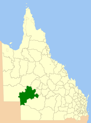
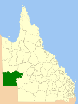
The Shire of Barcoo is a local government area in Central West Queensland, Australia. In June 2018, the shire had a population of 267 people.

<span class="mw-page-title-main">Shire of Diamantina</span> Local government area in Queensland, Australia

The Shire of Diamantina is a local government area in Central West Queensland, bordering South Australia and the Northern Territory. Its administrative centre is in the town of Bedourie.

<span class="mw-page-title-main">Jundah, Queensland</span> Town in Queensland, Australia

Jundah is a rural town and locality in the Shire of Barcoo, Queensland, Australia. Jundah is the administrative centre of the Barcoo Shire local government area. In the 2016 census, the locality of Jundah had a population of 106 people.

Kynuna is an outback town in the Shire of McKinlay and a locality split between the Shire of McKinlay and the Shire of Winton in Queensland, Australia. In the 2016 census the locality of Kynuna had a population of 55 people.

Minnamoolka is a locality in the Tablelands Region, Queensland, Australia. In the 2021 census, Minnamoolka had a population of 27 people.

<span class="mw-page-title-main">Cedar Creek, Queensland (Moreton Bay)</span> Suburb of City of Moreton Bay, Queensland, Australia

Cedar Creek is a rural locality in the City of Moreton Bay, Queensland, Australia. In the 2021 census, Cedar Creek had a population of 831 people.

<span class="mw-page-title-main">Grapetree, Queensland</span> Suburb of Toowoomba Region, Queensland, Australia

Grapetree is a rural locality in the Toowoomba Region, Queensland, Australia. In the 2021 census, Grapetree had a population of 42 people.

Bakers Bend is a rural locality in the Shire of Murweh, Queensland, Australia. In the 2021 census, Bakers Bend had a population of 7 people.

<span class="mw-page-title-main">Tanbar, Queensland</span> Suburb of Shire of Barcoo, Queensland, Australia

Tanbar is an outback locality in the Shire of Barcoo, Queensland, Australia. It is on the corner of Queensland's southern and western border with South Australia. In the 2016 census Tanbar had a population of 3 people.

Dumpy Creek is a rural locality in the Shire of Banana, Queensland, Australia. In the 2021 census, Dumpy Creek had a population of 16 people.

Rookwood is a rural locality in the Shire of Mareeba, Queensland, Australia. In the 2016 census Rookwood had a population of 0 people.

Diamantina Lakes is a locality in the Shire of Diamantina, Queensland, Australia. In the 2021 census, Diamantina Lakes had "no people or a very low population".

Dalrymple Creek is a locality in the Shire of Hinchinbrook, Queensland, Australia. In the 2021 census, Dalrymple Creek had a population of 51 people.

<span class="mw-page-title-main">Amaroo, Queensland</span> Suburb of Shire of Boulia, Queensland, Australia

Amaroo is an outback locality split between the Shire of Boulia and the Shire of Diamantina, both in Central Western Queensland, Australia. In the 2021 census, Amaroo had a population of 17 people.

<span class="mw-page-title-main">Forest Creek, Queensland</span> Suburb of Shire of Douglas, Queensland, Australia

Forest Creek is a locality in the Shire of Douglas, Queensland, Australia. In the 2021 census, Forest Creek had a population of 136 people.

Cona Creek is a locality in the Central Highlands Region, Queensland, Australia. In the 2021 census, Cona Creek had a population of 57 people.

<span class="mw-page-title-main">Carrandotta, Queensland</span> Suburb of Shire of Boulia, Queensland, Australia

Carrandotta is a locality in the Shire of Boulia, Queensland, Australia. It is on the border with the Northern Territory. In the 2021 census, Carrandotta had "no people or a very low population".

Orange Creek is a rural locality in the Shire of Banana, Queensland, Australia. In the 2021 census, Orange Creek had a population of 197 people.

References

  1. 1 2 3 Australian Bureau of Statistics (28 June 2022). "Farrars Creek (SAL)". 2021 Census QuickStats. Retrieved 28 February 2023. OOjs UI icon edit-ltr-progressive.svg
  2. "Farrars Creek – locality in Shire of Barcoo (entry 49157)". Queensland Place Names. Queensland Government . Retrieved 10 June 2019.
  3. 1 2 3 4 "Queensland Globe". State of Queensland . Retrieved 8 September 2023.
  4. CC BY icon-80x15.png This Wikipedia article incorporates CC-BY-4.0 licensed text from: "Indigenous languages map of Queensland". State Library of Queensland. State Library of Queensland . Retrieved 5 February 2020.
  5. "Farrars creek – watercourse in Barcoo Shire (entry 12240)". Queensland Place Names. Queensland Government . Retrieved 12 August 2019.
  6. Australian Bureau of Statistics (27 June 2017). "Farrars Creek (SSC)". 2016 Census QuickStats. Retrieved 20 October 2018. OOjs UI icon edit-ltr-progressive.svg