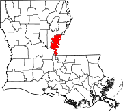
Concordia Parish borders the Mississippi River in eastern central Louisiana. As of the 2020 census, the population was 18,687. The parish seat is Vidalia. The parish was formed in 1807.

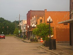
Clayton is a town in northern Concordia Parish, Louisiana, United States. The population was 711 at the 2010 census. Cotton is a principal commodity in the area. Clayton is located on the Tensas River, important for fishing and boating, promoted through a U.S. Army Corps of Engineers-maintained boat launch. The Tensas River merges with the Black River in Jonesville in Catahoula Parish.
West Ferriday is an Unincorporated Community and former census-designated place (CDP) in Concordia Parish, Louisiana, United States. The population was 1,541 at the 2000 census. The area was not delineated as a CDP for the 2010 or the 2020 census.

The Garden District is a neighborhood of the city of New Orleans, Louisiana, United States. A subdistrict of the Central City/Garden District Area, its boundaries as defined by the New Orleans City Planning Commission are: St. Charles Avenue to the north, 1st Street to the east, Magazine Street to the south, and Toledano Street to the west. The National Historic Landmark district extends a little farther.

Central City is a neighborhood of the city of New Orleans. It is located in the 11th Ward of New Orleans in Uptown, just above the Garden District, on the "lakeside" of St. Charles Avenue. A subdistrict of the Central City/Garden District Area, its boundaries as defined by the City Planning Commission are: MLK Boulevard, South Claiborne Avenue and the Pontchartrain Expressway to the north, Magazine, Thalia, Prytania and Felicity Streets and St. Charles Avenue to the south and Toledano Street, Louisiana Avenue and Washington Avenue to the west. This old predominantly African-American neighborhood has been important in the city's brass band and Mardi Gras Indian traditions.

The Downtown Miami Historic District is a U.S. historic district located in the Central Business District of Downtown Miami, Florida.
The Davenport Public Library is a public library located in Davenport, Iowa. With a history dating back to 1839, the Davenport Public Library's Main Library is currently housed in a 1960s building designed by Kennedy Center architect Edward Durell Stone. The Davenport Public Library system is made up of three libraries—the Main Library at 321 Main Street; the Fairmount Branch Library at 3000 N. Fairmount Street (41°33′06″N90°37′54″W); and the Eastern Avenue Branch Library at 6000 Eastern Avenue (41°34′59″N90°33′12″W).
Harvey and Clarke was an American architectural firm formed by Henry Stephen Harvey and L. Philips Clarke in West Palm Beach, Florida, in 1921. The firm was active in South Florida for only a few years, but in that time designed a number of distinctive homes, apartments, churches, and commercial buildings. Harvey was a member of the West Palm Beach Planning Commission. Firm member Gustav Maass designed several railroad stations, and became a noted South Florida architect in his own right.

Rosenørns Allé is a street located on the border between Frederiksberg and Nørrebro, on the west side of The Lakes, in Copenhagen, Denmark. The street branches from the south side of the busy thoroughfare Kampmannsgade-Åboulevard at the west end of the embankment which separates St. Jørgen's Lake from Peblinge Lake, runs west to Julius Thomsens Plads and then continues in a more northwesterly direction to Bülowsvej where it turns into Rolighedsvej and later Godthåbsvej before reaching Bellahøj in Brønshøj.
The Winnsboro Commercial Historic District is a 5.2 acres (2.1 ha) historic district located along Prairie Street in Winnsboro in Franklin Parish, Louisiana.

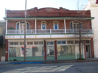
The Zappe Boarding House, located at 107 Virginia Avenue in Ferriday, Louisiana was built in 1922 with some elements of Craftsman architecture. It's a two-story building near where railroad tracks used to run.

Downtown Baton Rouge Historic District is a historic district in downtown Baton Rouge, Louisiana, located along 3rd Street, from Main Street to North Boulevard.
Main Street Historic District is a historic district in downtown Baton Rouge, Louisiana, located along Main Street, from North 4th Street to North 7th Street.

Plaquemine Historic District is a historic district in downtown Plaquemine, Louisiana, located along Railroad Avenue, Main Street, Eden Street, Church Street, Plaquemine Street and Court Street.

Gretna Historic District is a historic district in downtown Gretna, Louisiana, roughly bounded by 1st Street, Amelia Street, 9th Street, Gulf Drive, 4th Street and Huey P. Long Avenue.

The Downtown Ruston Historic District is a historic district located in downtown Ruston, Louisiana.

T.A. Oakes Building, is a historic commercial building in Carmel-by-the-Sea, California. It was built in 1922, by builder Thomas A. Oakes and designed by architect Thomas W. Morgan for a new Post Office and City Hall. It is an example of Western false front and Spanish Colonial Revival architecture styles. The building qualifies as an important building in the city's downtown historic district property survey and was recorded with the California Register of Historical Resources on October 28, 2002.