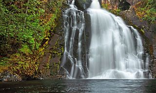
Youngs River Falls is a 54-foot (16 m) tall waterfall on the Youngs River in central Clatsop County, northwestern Oregon, United States. They are located about 10 miles (16 km) south of Astoria.
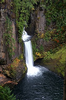
Toketee Falls is a waterfall in Douglas County, Oregon, United States, on the North Umpqua River at its confluence with the Clearwater River. It is located approximately 58 miles (93 km) east of Roseburg near Oregon Route 138.

Oregon Route 103 is a 9.02-mile-long (14.52-kilometer) highway in the U.S. state of Oregon that runs between Jewell Junction and Jewell. It is also known as the Fishhawk Falls Highway No. 103, named after nearby Fishhawk Falls.

Larch Mountain is an extinct volcano near Portland, Oregon. The name is misleading, as no western larch can be found there. It received that name when early lumbermen sold the noble fir wood as larch. The peak can be reached between May and November on paved Larch Mountain Road, 16 miles (26 km) east of Corbett, Oregon, although the road is closed during the winter and spring months.

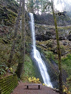
Silver Falls State Park is a state park in the U.S. state of Oregon, located near Silverton, about 20 miles (32 km) east-southeast of Salem. It is the largest state park in Oregon with an area of more than 9,000 acres (36 km2), and it includes more than 24 miles (39 km) of walking trails, 14 miles (23 km) of horse trails, and a 4-mile (6.4 km) bike path. Its 8.7-mile (14.0 km) Canyon Trail/Trail of Ten Falls runs along the banks of Silver Creek and by ten waterfalls, from which the park received its name. Four of the ten falls have an amphitheater-like surrounding that allows the trail to pass behind the flow of the falls. The Silver Falls State Park Concession Building Area and the Silver Creek Youth Camp-Silver Falls State Park are separately listed on the U.S. National Register of Historic Places.

Salt Creek Falls is a cascade and plunge waterfall on Salt Creek, a tributary of the Middle Fork Willamette River, that plunges into a gaping canyon near Willamette Pass in the Willamette National Forest, near Oakridge, Oregon. The waterfall is notable for its main drop of 286 feet (87 m) which makes it the third highest plunge waterfall in Oregon after Multnomah Falls and Watson Falls the second highest, which was re-measured in 2009 and found to be 293 feet rather than an earlier measurement of 272 feet passing Salt Creek Falls. The pool at the bottom of the waterfall is 20 metres (66 ft) deep.
Jewell Junction is a highway junction and unincorporated community in Clatsop County, Oregon, United States. It is located at the intersection of U.S. Route 26 and Oregon Route 103, approximately nine miles southwest of Jewell.

Frustration Falls, is a three drop waterfall located on the Salmon River at the south skirt of the Mount Hood National Forest, in Clackamas County, in the U.S. state of Oregon. It is located in a privileged area where the river creates several waterfalls: Final Falls, Vanishing Falls, Little Niagara Falls, and Copper Creek Falls are within a mile from Frustration Falls; while Hideaway Falls, Split Falls, and Stein Falls are approximately two miles away.

South Falls, is a waterfall located in the Silver Falls State Park at the east end of the city of Salem, in Marion County, in the U.S. state of Oregon. It is located in a privileged area on the west foothills where Mount Hood National Forest meets with the Middle Santiam Wilderness. Several prominent waterfalls are located in the Park along Trail of Ten Falls: Lower South Falls, Drake Falls, Lower North Falls, and Winter Falls—among others.

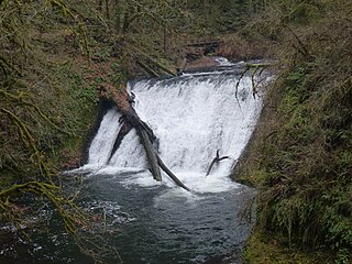
Lower South Falls, is a waterfall located in the Silver Falls State Park at the east end of the city of Salem, in Marion County, in the U.S. state of Oregon. It is located in a privileged area on the west foothills where Mount Hood National Forest meets with the Middle Santiam Wilderness. Several prominent waterfalls are located in the Park along Trail of Ten Falls: South Falls, Drake Falls, Middle North Falls, and Winter Falls—among others.
Winter Falls, is a waterfall located in the Silver Falls State Park at the east end of the city of Salem, in Marion County, in the U.S. state of Oregon. It is located in a privileged area on the west foothills where Mount Hood National Forest meets with the Middle Santiam Wilderness. Several prominent waterfalls are located in the Park along Trail of Ten Falls: South Falls, Lower South Falls, Lower North Falls, and Drake Falls—among others.
Lower North Falls, is a waterfall located in the Silver Falls State Park at the east end of the city of Salem, in Marion County, in the U.S. state of Oregon. It is located in a privileged area on the west foothills where Mount Hood National Forest meets with the Middle Santiam Wilderness. Several prominent waterfalls are located in the Park along Trail of Ten Falls including South Falls, Drake Falls, Middle North Falls and Winter Falls.

Upper North Falls, is a waterfall located in the Silver Falls State Park at the east end of the city of Salem, in Marion County, in the U.S. state of Oregon. It is located in a privileged area on the west foothills where Mount Hood National Forest meets with the Middle Santiam Wilderness. Several prominent waterfalls are located in the Park along Trail of Ten Falls: South Falls, Drake Falls, Lower North Falls, and Winter Falls—among others.

North Falls is a waterfall located in the Silver Falls State Park at the east end of the city of Salem, in Marion County, in the U.S. state of Oregon. It is located in a privileged area on the west foothills where Mount Hood National Forest meets with the Middle Santiam Wilderness. Several prominent waterfalls are located in the Park along Trail of Ten Falls: South Falls, Drake Falls, Lower South Falls, and Winter Falls—among others.

Twin Falls is a waterfall located in the Silver Falls State Park at the east end of the city of Salem, in Marion County, in the U.S. state of Oregon. It is located in the west foothills where Mount Hood National Forest meets with the Middle Santiam Wilderness. Several prominent waterfalls are located in the Park along Trail of Ten Falls: South Falls, Drake Falls, Lower South Falls, and Winter Falls—among others.
Double Falls, is a waterfall located in the Silver Falls State Park at the east end of the city of Salem, in Marion County, in the U.S. state of Oregon. It is located on the west foothills where Mount Hood National Forest meets with the Middle Santiam Wilderness. Several prominent waterfalls are located in the Park along Trail of Ten Falls: South Falls, Drake Falls, Middle North Falls, and Winter Falls—among others.
Barth Falls, is a small waterfall located along the North Fork Klaskanine River in Clatsop County, in the U.S. state of Oregon. The waterfall is known for a three step fish ladder that bypasses the waterfall to assist fish navigate the waterfall.
Beaver Creek Falls, is a small waterfall located at the confluence of Beaver and Sweet Creeks in Lane County, in the U.S. state of Oregon. The waterfall is known for joining of the two creeks becoming one intertwined waterfall.
Beaver Falls, is a waterfall located on Beaver Creek near the town of Clatskanie in Columbia County, in the U.S. state of Oregon.

Lee Falls is a waterfall on the Tualatin River in Washington County in the U.S. state of Oregon. Named after 19th century sawmill owner James A. Lee, it is located alongside Southwest Lee Falls Road on private timber land. The falls pour over a basalt rock formation. Unusually for the region, the falls are wider than they are tall. A swimming hole is present beneath the falls. Downstream is the unincorporated community of Cherry Grove. Upstream is Ki-a-Kuts Falls.
