
Boston is a market town and inland port in the borough of the same name in the county of Lincolnshire, England.

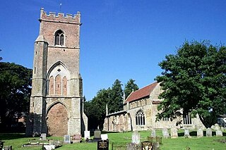
Crowland or Croyland is a town and civil parish in the South Holland district of Lincolnshire, England. It is situated between Peterborough and Spalding. Crowland contains two sites of historical interest, Crowland Abbey and Trinity Bridge.

St Botolph's Church is the Anglican parish church of Boston, Lincolnshire, England. It has been referred to as "Boston Stump" since it was constructed. Its tower is 266 feet 9 inches (81.31 m) tall, and was long used as a landmark for the Boston fishermen; on a clear day it can be seen from Norfolk. The church is a Grade I listed building.

The Fens or Fenlands in eastern England are a naturally marshy region supporting a rich ecology and numerous species. Most of the fens were drained centuries ago, resulting in a flat, dry, low-lying agricultural region supported by a system of drainage channels and man-made rivers and automated pumping stations. There have been unintended consequences to this reclamation, as the land level has continued to sink and the dykes have been built higher to protect it from flooding.

Minster, also known as Minster-in-Thanet, is a village and civil parish in the Thanet District of Kent, England. It is the site of Minster in Thanet Priory. The village is west of Ramsgate and to the north east of Canterbury; it lies just south west of Kent International Airport and just north of the River Stour. Minster is also the "ancient capital of Thanet". At the 2011 Census the hamlet of Ebbsfleet was included.

Walsingham is a civil parish in North Norfolk, England, famous for its religious shrines in honour of Mary, mother of Jesus. It also contains the ruins of two medieval monastic houses. Walsingham is 27 miles northwest of Norwich.

Immingham is a town and civil parish in North East Lincolnshire, in Lincolnshire, England. It is situated on the south-west bank of the Humber Estuary, and is six miles northwest of Grimsby.
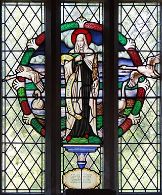
Pega is a Christian saint who was an anchoress in the ancient Anglo-Saxon kingdom of Mercia, and the sister of St Guthlac.

Deeping St James is a large village in the South Kesteven district of Lincolnshire, England. The population of the civil parish was reported as 7,051 at the 2011 census.

Saint Guthlac of Crowland was a Christian hermit and saint from Lincolnshire in England. He is particularly venerated in the Fens of eastern England.
The Deepings are a series of settlements close to the River Welland near the borders of southern Lincolnshire and north western Cambridgeshire in eastern England. Peterborough is about 8 miles to the south, Spalding about 10 miles to the north east and Stamford about 8 miles to the west.

Freiston is a village and civil parish in Lincolnshire, England. The population of the civil parish at the 2011 census was 1,306. It is situated approximately 2 miles (3 km) east from Boston. The Greenwich Prime Zero meridian line passes between the village and Hobhole Drain.
Tydd St Giles is a village and civil parish in Fenland, Cambridgeshire, England. It is the northernmost village in the Isle of Ely, Cambridgeshire, on the same latitude as Midlands towns such as Loughborough and Shrewsbury. In 2011 the parish had a population of 1101.

Crowland Abbey is a Church of England parish church, formerly part of a Benedictine abbey church, in Crowland in the English county of Lincolnshire. It is a Grade I listed building.
Medeshamstede was the name of Peterborough in the Anglo-Saxon period. It was the site of a monastery founded around the middle of the 7th century, which was an important feature in the kingdom of Mercia from the outset. Little is known of its founder and first abbot, Sexwulf, though he was himself an important figure, and later became bishop of Mercia. Medeshamstede soon acquired a string of daughter churches, and was a centre for an Anglo-Saxon sculptural style.
Brothertoft is a village in the civil parish of Holland Fen with Brothertoft, in the Boston district, in the county of Lincolnshire, England. It is about 4 miles (6.4 km) northwest from the market town of Boston.
Cowbit is a village and civil parish in the South Holland district of Lincolnshire, England. The population of the civil parish at the 2011 census was 1,220. It is situated 3 miles (5 km) south from Spalding and 5 miles (8 km) north from Crowland.

Little Ponton is a village in the civil parish of Little Ponton and Stroxton, in the South Kesteven district of Lincolnshire, England. It lies 2 miles (3 km) south of Grantham, about 60 metres (200 ft) above sea level.

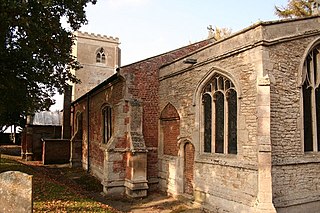
Skirbeck is a historic village and suburb of Boston in Lincolnshire, England. Skirbeck is a long v-shaped formation wrapped around the south and east side of Boston parish. It has been incorporated into the Borough of Boston since 1932. It is in the Skirbeck ward of the Boston Borough Council. Skirbeck includes the hamlet and former civil parish of Skirbeck Quarter which was on the west side of the River Witham and was a separate parish from 1866 to 1932.


